Topics > Heritage Sites > Hadrian's Wall > Wall Mile 52 > Turret 52a (Banks East)
Turret 52a (Banks East)
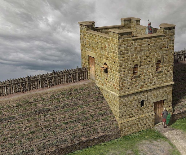
Turrets on Hadrian’s Wall were small watchtowers built into the wall, with two turrets per Roman mile, located between larger milecastles. They provided elevated viewpoints for small groups of 4 to 6 soldiers to spot threats and offer basic shelter for patrols. Turrets significantly enhanced continuous surveillance and control of the frontier by housing sentries between main garrisons. Their importance lay in forming an integrated part of the wall’s defensive system, enabling rapid communication and constant vigilance against incursions, turning the wall into a manned frontier rather than a simple barrier. Under a naming system introduced in 1930, turrets are numbered 1 to 80 from east (A) to west (B) and given numbers as pairs, taking the number of the nearest milecastle to their east.


from Flickr (flickr)
Wall Mile 52 - Turret 52a (Banks East Turret), Hadrian's Wall
Pinned by Simon Cotterill


from Geograph (geograph)
The north defensive ditch of Hadrian's Wall at Turret 52a (Banks East)
Pinned by Simon Cotterill

from Flickr (flickr)
Wall Mile 52 - Turret 52a (Banks East Turret), Hadrian's Wall
Pinned by Simon Cotterill


from https://historicengland.org.u…
Hadrian's Wall and vallum between the field boundary west of Coombe Crag and Banks Green Cottage and the road to Lanercost at Banks in wall miles 51 and 52 - List Entry
- ....The monument includes the section of Hadrian's Wall and vallum and their associated features between the field boundary west of Coombe Crag in the east and Banks Green Cottage and …
Added by
Simon Cotterill
from https://www.english-heritage.…
Banks East Turret - Hadrian's Wall
- Visitor information and a section on history.
Added by
Simon Cotterill

from Flickr (flickr)
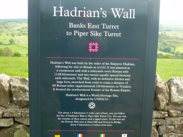
Information panel at Banks East Turret 52a, Hadrian's Wall
Pinned by Simon Cotterill


from Flickr (flickr)
Wall Mile 52 - Turret 52a (Banks East Turret), Hadrian's Wall
Pinned by Simon Cotterill

from Flickr (flickr)
Wall Mile 52 - Turret 52a (Banks East Turret), Hadrian's Wall
Pinned by Simon Cotterill
from Geograph (geograph)
The north defensive ditch of Hadrian's Wall at Turret 52a (Banks East)
Pinned by Simon Cotterill
from Flickr (flickr)
Wall Mile 52 - Turret 52a (Banks East Turret), Hadrian's Wall
Pinned by Simon Cotterill
from https://historicengland.org.u…
Hadrian's Wall and vallum between the field boundary west of Coombe Crag and Banks Green Cottage and the road to Lanercost at Banks in wall miles 51 and 52 - List Entry
- ....The monument includes the section of Hadrian's Wall and vallum and their associated features between the field boundary west of Coombe Crag in the east and Banks Green Cottage and …
Added by
Simon Cotterill
from https://www.english-heritage.…
Banks East Turret - Hadrian's Wall
- Visitor information and a section on history.
Added by
Simon Cotterill
from Flickr (flickr)
Information panel at Banks East Turret 52a, Hadrian's Wall
Pinned by Simon Cotterill
from Flickr (flickr)
Wall Mile 52 - Turret 52a (Banks East Turret), Hadrian's Wall
Pinned by Simon Cotterill


