Topics > Northumberland > Stobbs (Byrness)
Stobbs (Byrness)
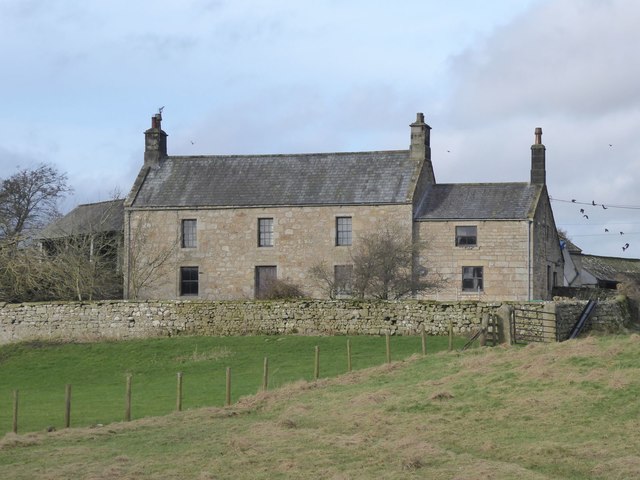
Stobbs is a farm located on the east banks of the River Rede, about ½mile south-east of the village of Rochester, in Northumberland. There is a minor road leading off the A68 to Stobbs, continuing to a bridge over the River Rede and onwards to Evistones Farm. The farmhouse at Stobbs dates from the 17th century, extended in 1724 and with later alterations[1]. It is a Grade II listed building on the National Heritage List for England. The garden walls to the house date from the 18th century, and separately Grade II listed. Whellan's directory of Northumberland in 1855 lists Stubbs (Stobbs) under Rocherster Ward in the ancient parish of Elsdon, and the farmer at that time as George Hedley[2]. Today, Stobbs is part of Rochester and Byrness Civil Parish.


from https://historicengland.org.u…
STOBBS - Rochester with Byrness - List Entry
- House. C17, altered and extended 1724. Large random rubble blocks; extended in ashlar. Welsh slate roof. Two storeys, 3 bays with lower 2-storey, one- bay extension on right.
C20 central …
Added by
Simon Cotterill
from https://historicengland.org.u…
GARDEN WALL TO SOUTH OF STOBBS - Rochester with Byrness - List Entry
- Garden wall. C18. Dressed stone wall 3-4 feet high with shallow arched coping. Included for group value....
Added by
Simon Cotterill

from https://historicengland.org.u…
STOBBS - Rochester with Byrness - List Entry
- House. C17, altered and extended 1724. Large random rubble blocks; extended in ashlar. Welsh slate roof. Two storeys, 3 bays with lower 2-storey, one- bay extension on right.
C20 central …
Added by
Simon Cotterill
from https://historicengland.org.u…
GARDEN WALL TO SOUTH OF STOBBS - Rochester with Byrness - List Entry
- Garden wall. C18. Dressed stone wall 3-4 feet high with shallow arched coping. Included for group value....
Added by
Simon Cotterill


List grade: 2
Keys to the Past HER: N8112
County: Northumberland
Grid ref: NY8377897099


