Boldron village well


-
Description
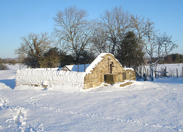
"The structure seen here was rebuilt in 2007 under the aegis of the Boldron Parish History Group with the aid of a grant from "Awards For All". This involved the removal of seedling trees up to 6m high which were beginning to break up the walls, last repaired in 1987. The well has a long history, being referred to as "an Ancient Well called Athelstan Well" in the "Plan and Apportionment for the 1768 Parliamentary Act of Enclosure of Boldron Moor". A Victorian iron pipe leads from the well to troughs at Abbey Farm [[NZ0615]], and a plan drawn for the Lowther family in 1802 shows the route of that pipe as being a "strand" or open drain at that time. It is thought likely that this originally supplied water to Egglestone Abbey. Although there were various wells in the vicinity of Boldron, this one was the only one not to run dry in times of drought, being situated above the end of the great limestone mass that forms Kilmond Scar to the south and west of the village. The current structure is thought to date from 1879 and consists of a stone wall topped with a wire fence. Inside this enclosure is the well, the walls made of finely sawn sandstone blocks fitted together without mortar and enclosing a space 2.4 x 1.5 m, aligned east-west. The well is spring fed, and is currently roofed over to keep debris out. A large stone slab covers the three stone steps leading down into the well. A cast iron pipe feeds the pump attached to the south wall, with a water trough and run-off below. The north wall is pierced by a hand-cut stone channel and the east wall by an overflow to a surface drain into Thorsgill Beck. Reliance on water from wells decreased with the arrival in the village of piped water in 1902, although this too came from a spring a kilometre or so away, and supplied just two hydrants and a trough within the village. Mains water was first piped from Bowes in 1958, though limescale proved to be a problem until the Bowes supply was linked to Lartington water treatment works in 1974. Most of this information has been taken from an informative leaflet and website published by the Boldron Parish History Group www.boldronhistory.com" Photo by Andy Waddington, 2009. -
Owner
Andy Waddington -
Source
Geograph (Geograph) -
License
What does this mean? Creative Commons License
-
Further information
Link: http://www.geograph.org.uk/photo/1640112
Resource type: Image
Added by: Simon Cotterill
Last modified: 8 years, 9 months ago
Viewed: 1994 times
Picture Taken: 2009-12-25 -
Co-Curate tags


