Topics > County Durham > Civil Parishes in County Durham > Bowes Civil Parish > Old Boundary Marker on Drover Hole Hill
Old Boundary Marker on Drover Hole Hill
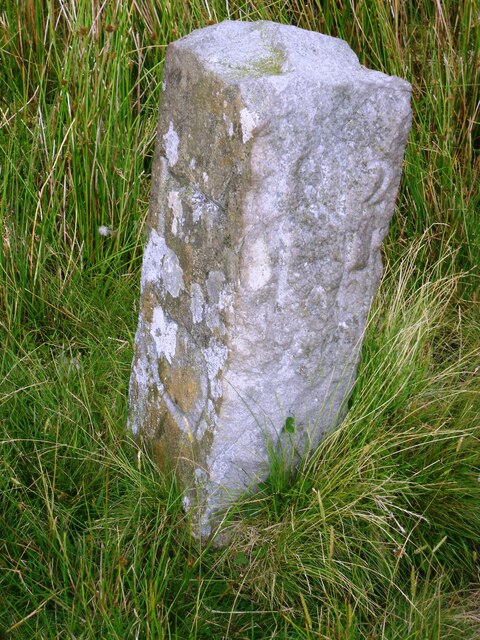
This old boundary stone is in a remote location on Drover Hole Hill, besides Regional Route 71, about half mile north-west of Tan Hill Inn. The estate boundary marker is a carved rough-dressed stone, about 2½ ft high, with "LO" carved on it's north face, "1912 LH" carved on it's west face. Standing on the county border and the point where 3 civil parishes meet, the marker tells the tale of changing boundaries. The 3 civil parishes bordering here are: Kaber Parish (historically in the county of Westmorland, now Cumbria), Bowes Parish (historically North Riding of Yorkshire, now County Durham), and Muker Parish (historically North Riding of Yorkshire, now North Yorkshire). The boundary marker is Grade II listed on the National Heritage List for England.

from https://historicengland.org.u…
Boundary Stone to Cumbria/north Yorks - List Entry
- Boundary stone; mid C19. Rough-dressed c2½ ft high, square in plan. LO carved
on north face, 1912 LH carved on west face....
Added by
Simon Cotterill

from https://historicengland.org.u…
Boundary Stone to Cumbria/north Yorks - List Entry
- Boundary stone; mid C19. Rough-dressed c2½ ft high, square in plan. LO carved
on north face, 1912 LH carved on west face....
Added by
Simon Cotterill


List grade: 2
County: County Durham
Grid ref: NY8906506992
Milestone id: WE_CBDM153em
