Topics > County Durham > Civil Parishes in County Durham > Bowes Civil Parish > Historic Buildings and Monuments in Bowes Civil Parish
Historic Buildings and Monuments in Bowes Civil Parish
Listed buildings and scheduled monuments in Bowes Civil Parish, County Durham, from the National Heritage List for England[1]. In the absence of a published 'local list', some other public buildings of interest may also be included. Use the Search (below) if looking for a specific building / monument.
| Structure | List No. | Grade | Built~ | Notes |
|---|---|---|---|---|
| Nos. 1 and 2, The Street | 1159738 | II | C18th | |
| Annums Farmhouse | 1121073 | II | C19th | The Street |
| Barn, Yard Wall and Shed to East and South of Levy Pool Farmhouse | 1323026 | II | C19th | |
| Base and Cross Shaft Fragment in the Garden of Cross House | 1159719 | II | Medieval | The Street |
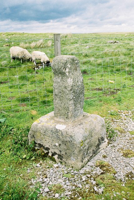
| Boundary Stone to Cumbria/North Yorks | 1327013 | II | 1912 | Drover Hole Hill |
| Bowes and District Working Men's Club | 1323029 | II | C18th | now Bowes Social Club |
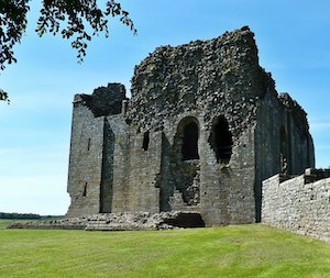
| Bowes Castle | 1121039 | I | 1174 | On the site of a Roman fort |
| Bowes Hall | 1121071 | II | C17th | The Street |
| Bowfield Cottage | 1121070 | II | C19th | Rutherford Lane |
| Bridge, 220 Metres North of East Mellwaters Farmhouse | 1121067 | II | C18th | |
| Byre Adjoining to Left of Levy Pool Farmhouse | 1159654 | II | C18th | |
| Castle Terrace | 1121038 | II | C19th | 8-9, The Street |
| Chest Tomb to William Thompson, 8 Metres West of Church of St Giles | 1121035 | II | 1790 | Church of St Giles |
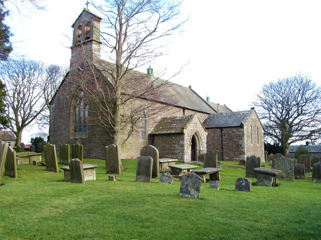
| Church of St Giles | 1323050 | II | C12th | |
| Croft House Attached Extension and Sunny Croft | 1121033 | II | C18th | |
| Cross House and Church View | 1323028 | II | c.1840 | The Street |
| Dotheboys Hall and Former Coach House | 1121040 | II | C18th | Former Bowes Academy |
| Farmbuilding Attached to Hulands Cottage, 180 Metres East of High Broats Farmhouse | delisted | C17th | NZ0143613898 Info | |
| Forecourt Wall and Gatepiers in Front of the Grove | 1121072 | II | C18th | |
| Garden Walls Gate Piers and Gates Adjoining South Front of Bowes Hall | 1310919 | II | C18th | |
| Headstone to Thomas Hanby, 1 Metre South of Church of St Giles | 1121034 | II | 1760 | Church of St Giles |
| Headstone to William Shaw, 3 Metres North of Church of St Giles | 1121037 | II | 1850 | Church of St Giles |
| Levy Pool Farmhouse | 1310940 | II | 1736 | |
| Limekiln 60 Metres South of God's Bridge Cottage | 1121825 | II | C19th | God's Bridge |
| Limekiln, 30 Metres South of Gods Bridge Cottage (Shown on Os Map As Rock Bridge Cottages) | 1323024 | II | C19th | God's Bridge |
| Linked Farmbuildings and Gin-Gang, Attached to South of Stone Bridge Farmhouse | 1323063 | II | C19th | Stone Bridge |
| Loose Boxes, 5 Metres East of Stone Bridge Farmhouse | 1121066 | II | C19th | Stone Bridge |
| Milestone, 35 Metres West of Milestone House (Shown on Os Map As New House) | 1121069 | II | C19th | A67 |
| Milestone, 650 Metres West of Ivy Hall | 1323062 | II | C19th | A66 |
| Nabb Bridge, 160 Metres West of Nabb House | 1310969 | II | C18th | |
| Old Spital Farmhouse | 1121068 | II | C18th | A66 |
| Prospect House and Archway to Right | 1159724 | II | C18th | The Street |
| Rey Cross | 1323025 | II* | C10th | Historic boundry marker, A66 |
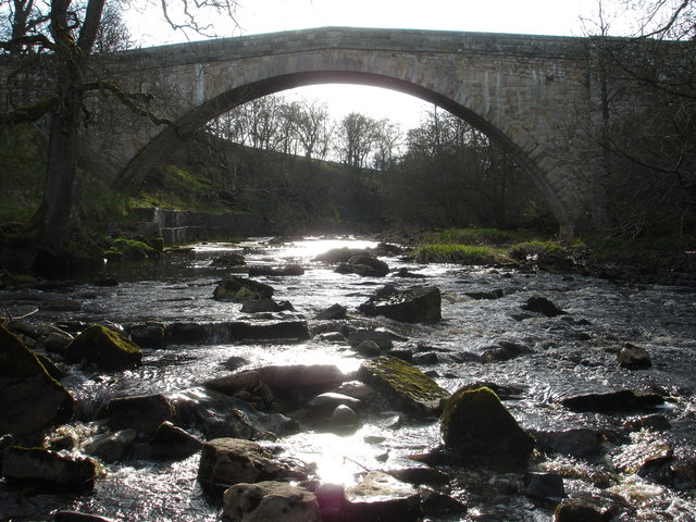
| Rutherford Bridge | 1121822 | II | 1773 | |
| Stone Bridge Farmhouse | 1121065 | II | c.1840 | A66 |
| Table Tomb to Henry Bincks, 4 1/2 Metres West of Church of St Giles | 1121036 | II | 1691 | Church of St Giles |
| The Ancient Unicorn Hotel and Attached Rear Wing (Shown on Os Map As Unicorn House) | 1323027 | II | C17th | The Street, Bowes |
| The Grove | 1159713 | II | C18th | The Street, Bowes |
| West End Farm Barn and Attached Range of Byres, 20 Metres North of Dotheboys Hall | 1121074 | II | C19th | |
| Bowes Castle | 1002318 | n/a | 1174 | Scheduled Monument |
| Cairnfield on the north east slope of Ravock, Bowes Moor | 1016605 | n/a | Scheduled Monument | |
| Cairnfield on Ravock, 600m south east of Ravock Castle, Bowes Moor | 1016610 | n/a | Scheduled Monument | |
| Cairn on a prominent knoll and cairnfield to its south east on Ravock, Bowes Moor | 1016608 | n/a | Scheduled Monument | |
| Three cairns on Ravock, Bowes Moor, 830m north east of Ravock Castle | 1016606 | n/a | Scheduled Monument | |
| Cairn on the north side of Ravock, Bowes Moor, 600m west of West Stoney Keld | 1016611 | n/a | Scheduled Monument | |
| Roman signal station and camp 270m north east of Bowes Moor Hotel | 1016463 | n/a | Roman | Scheduled Monument |
| Cairn on a low ridge on the east side of Ravock, Bowes Moor, 860m west south west of West Stoney Keld | 1016607 | n/a | Scheduled Monument | |
| Cairnfield on Ravock, 880m north west of Rovegill House | 1016609 | n/a | Scheduled Monument | |
| Roman signal station 190m north west of Vale House Farm | 1016464 | n/a | Roman | Scheduled Monument |
| Roman aqueduct, prehistoric field systems, cairnfield, enclosure and round cairn on Ravock | 1021117 | n/a | Roman | Scheduled Monument |
| Rey Cross Roman temporary camp and signal station, and prehistoric stone circle | 1016929 | n/a | Roman | Scheduled Monument |
| Romano-British settlement site to the east and south-east of East Mellwaters farmhouse | 1459288 | n/a | Scheduled Monument | |
| Roman Fort (Lavatrae) | 1002316 | n/a | Roman | Scheduled Monument |
| Romano-British settlement 740m WNW of Old Spital | 1016465 | n/a | Scheduled Monument | |
| Rey Cross, 670m west of Old Spital | 1016467 | n/a | Medieval | Scheduled Monument |
| Unenclosed hut circle settlement, two round cairns, medieval transhumance settlement and two pillow mounds, 360m south east of Rey Cross Roman camp | 1016468 | n/a | Scheduled Monument | |
| Bowes Hutchinsons Primary School | not listed | n/a | C19th | |
| Lime Kiln to east of God's Bridge | not listed | n/a | C19th | God's Bridge |
| Milestone, A66, west of Bowes Cross Farm | not listed | n/a | C19th | A66 |
Primary source: the National Heritage List for England - NHLE is the register of nationally protected historic buildings and sites in England, including listed buildings, scheduled monuments, protected wrecks, registered parks and gardens, and battlefields. The list is maintained by Historic England. Check NHLE for updates and new entries. Secondary sources: British Listed Buildings and Keys to the Past.
Co-Curate Page
Bowes Castle
- Overview History Map The stone castle at Bowes was built between 1170 and 1174 on the site of the former Roman fort of Lavatrae. Bowes Castle was a medieval castle …
Co-Curate Page
Rey Cross, west of Bowes
- Overview Map Street View Rey Cross is located at the side of a layby on the north side of the A66 road, about 5 miles west of Bowes. This is …
Co-Curate Page
Rutherford Bridge
- Overview Map Street View A stone bridge over the River Greta just over a mile North West of Scargill, County Durham. The bridge was built in 1773 following the great …

Co-Curate Page
Lavatrae Roman Fort
- % Map showing the Scheduled Monument area for Lavatrae Roman Fort Lavatrae was a Roman auxiliary fort situated by the River Greta, located in modern-day Bowes in County Durham. It …

Co-Curate Page
The Ancient Unicorn, Bowes
- Overview Map Street View The Ancient Unicorn is located on The Street in Bowes. The front block dates from the mid-18th century, and there is an altered and refronted 17th …

Co-Curate Page
Dotheboys Hall, Bowes
- Overview Map Street View Dotheboys Hall is a large house on The Street in Bowes. It was formerly The Bowes Academy (aka Shaw's Academy), now divided into 7 flats. The …

Co-Curate Page
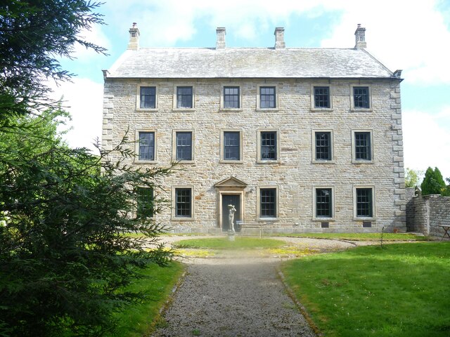
The Grove (house), Bowes
- The Grove is a large house, on the north side of The Street, in Bowes. The 3 storey house dates from the mid-18th century, with late-19th century alterations.
Co-Curate Page
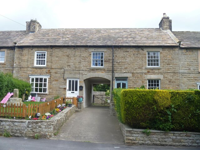
Cross House and Church View, Bowes
- Overview Map Street View Cross House and Church View are a pair of houses, with a central segmental archway, located on The Street in Bowes. They date from c.1840 with …

Co-Curate Page
Medieval Wayside Cross, Bowes
- Overview Map Street View The substantial remains of a Medieval wayside cross are located in the front garden of Cross House, on the north side of The Street in Bowes. …

Co-Curate Page
Bowes Social Club
- Overview Map Street View Bowes Social Club is located at No. 2 The Wynd, in Bowes. It was originally a house, built in the mid-18th century. Previously this was the …

Co-Curate Page
Stonebridge, Bowes
- Overview Map Street View Stonebridge (aka Stone Bridge) is located by the A66 road, about ¾mile east of Bowes. In the 1870s the house here was the Highland Bullock Inn, …
Co-Curate Page
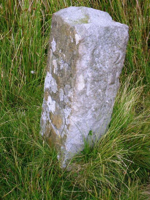
Old Boundary Marker on Drover Hole Hill
- Overview Map Street View This old boundary stone is in a remote location on Drover Hole Hill, besides Regional Route 71, about half mile north-west of Tan Hill Inn. The …


Co-Curate Page
Lime Kiln east of God's Bridge
- Overview Map Street View There is an old lime kiln on the south banks of the River Greta, located about ¼mile east of God's Bridge.

Co-Curate Page
Milestone, A66, west of Bowes Cross Farm
- Overview Map Street View There is an old Milestone on the north side of the A66 by the Holcim Durham plant, about 1¼ miles east of Bowes. The milestone was …

Co-Curate Page
Bowes Castle
- Overview History Map The stone castle at Bowes was built between 1170 and 1174 on the site of the former Roman fort of Lavatrae. Bowes Castle was a medieval castle …
Co-Curate Page
Rey Cross, west of Bowes
- Overview Map Street View Rey Cross is located at the side of a layby on the north side of the A66 road, about 5 miles west of Bowes. This is …
Co-Curate Page
Rutherford Bridge
- Overview Map Street View A stone bridge over the River Greta just over a mile North West of Scargill, County Durham. The bridge was built in 1773 following the great …
Co-Curate Page
Lavatrae Roman Fort
- % Map showing the Scheduled Monument area for Lavatrae Roman Fort Lavatrae was a Roman auxiliary fort situated by the River Greta, located in modern-day Bowes in County Durham. It …
Co-Curate Page
The Ancient Unicorn, Bowes
- Overview Map Street View The Ancient Unicorn is located on The Street in Bowes. The front block dates from the mid-18th century, and there is an altered and refronted 17th …
Co-Curate Page
Dotheboys Hall, Bowes
- Overview Map Street View Dotheboys Hall is a large house on The Street in Bowes. It was formerly The Bowes Academy (aka Shaw's Academy), now divided into 7 flats. The …
Co-Curate Page
The Grove (house), Bowes
- The Grove is a large house, on the north side of The Street, in Bowes. The 3 storey house dates from the mid-18th century, with late-19th century alterations.
Co-Curate Page
Cross House and Church View, Bowes
- Overview Map Street View Cross House and Church View are a pair of houses, with a central segmental archway, located on The Street in Bowes. They date from c.1840 with …
Co-Curate Page
Medieval Wayside Cross, Bowes
- Overview Map Street View The substantial remains of a Medieval wayside cross are located in the front garden of Cross House, on the north side of The Street in Bowes. …
Co-Curate Page
Bowes Social Club
- Overview Map Street View Bowes Social Club is located at No. 2 The Wynd, in Bowes. It was originally a house, built in the mid-18th century. Previously this was the …
Co-Curate Page
Stonebridge, Bowes
- Overview Map Street View Stonebridge (aka Stone Bridge) is located by the A66 road, about ¾mile east of Bowes. In the 1870s the house here was the Highland Bullock Inn, …
Co-Curate Page
Old Boundary Marker on Drover Hole Hill
- Overview Map Street View This old boundary stone is in a remote location on Drover Hole Hill, besides Regional Route 71, about half mile north-west of Tan Hill Inn. The …
Co-Curate Page
Lime Kiln east of God's Bridge
- Overview Map Street View There is an old lime kiln on the south banks of the River Greta, located about ¼mile east of God's Bridge.


