Topics > Civil Parishes in Cumbria > Penrith Town Council area > Historic Buildings and Monuments in Penrith
Historic Buildings and Monuments in Penrith
Listed buildings and scheduled monuments in Penrith, Cumbria, from the National Heritage List for England[1]. Use the Search (below) if looking for a specific building / monument.
| Structure | List No. | Grade | Built~ | Notes |
|---|---|---|---|---|
| Nos. 1 and 2, Crown Square | 1145123 | II | ||
| Nos. 1 and 2, Middlegate | 1145081 | II | ||
| Nos. 1, 2 and 3, Bishop Yards | 1326890 | II* | ||
| Nos. 1-3, Kitchenhill | 1326911 | II | ||
| Nos. 1-8, Wordsworth Terrace | 1177623 | II | ||
| Nos. 11 and 12, Little Dockray | 1145078 | II | ||
| Nos. 11 and 12, St Andrew's Churchyard | 1145053 | II | ||
| Nos. 11 and 12, West Lane | 1326906 | II | ||
| Nos. 11 and 14, Queen Street | 1145085 | II | ||
| No. 11, Devonshire Street | 1145125 | II | ||
| Nos. 12 and 13, Albert Street | 1145137 | II | ||
| No. 12, Devonshire Street | 1137904 | II | ||
| No. 12, King Street | 1145070 | II | ||
| Nos. 13, 14 and 15, Sandgate | 1145056 | II* | ||
| No. 13, Devonshire Street | 1326918 | II | ||
| Nos. 14-17, Meeting House Lane | 1145080 | II | ||
| Nos. 17 and 18, Devonshire Street | 1145086 | II* | ||
| No. 17, Queen Street | 1326935 | II | ||
| No. 18, Brunswick Square | 1145112 | II | ||
| Nos. 19 and 20, Arthur Street | 1145140 | II | ||
| Nos. 19, 20, 20a and 21, King Street | 1145071 | II | ||
| Nos. 19-21, Little Dockray | 1312035 | II | ||
| Nos. 19-22, Queen Street | 1145044 | II | ||
| Two Gate Piers to the Forecourt of the Mansion House | 1145110 | II* | ||
| Nos. 2-4, St Andrew's Churchyard | 1145051 | II | ||
| No. 20, Victoria Road | 1145064 | II | ||
| No. 21, Arthur Street | 1312140 | II | ||
| No. 21, Great Dockray | 1137950 | II | ||
| No. 21, Stricklandgate | 1138227 | II | ||
| Nos. 23, 24 and 25, Great Dockray | 1145100 | II | ||
| No. 23, Devonshire Street | 1326919 | II | ||
| Nos. 24 and 25, Corn Market | 1137872 | II | ||
| Nos. 24 and 25, Queen Street | 1145045 | II | ||
| No. 25a, Corn Market | 1326895 | II | ||
| Nos. 26, 27, 27a, 28 and 28a, King Street | 1145072 | II | ||
| No. 26, Corn Market | 1312107 | II | ||
| No. 26, Great Dockray | 1326885 | II | ||
| Nos. 26-29, Albert Street | 1145138 | II | ||
| Nos. 3 and 4, Devonshire Street | 1145124 | II | ||
| Nos. 3, 4 and 5, Corn Market | 1312104 | II | ||
| Nos. 3-5, Middlegate | 1326915 | II | ||
| Nos. 30 and 31, Arthur Street | 1145141 | II | ||
| Nos. 30, 30a and 31, King Street | 1312022 | II | ||
| Nos. 30, 31 and 32, Albert Street | 1145139 | II | ||
| No. 36, Great Dockray | 1312074 | II | ||
| Nos. 37, 38 and 39, Great Dockray | 1326886 | II | ||
| No. 4, Angel Lane | 1326903 | II* | ||
| No. 4, Great Dockray | 1137943 | II | ||
| Nos. 41 and 42, King Street | 1326910 | II | ||
| Nos. 43 and 44, King Street | 1138031 | II | ||
| Nos. 45 and 46, Burrowgate | 1145114 | II | ||
| No. 46, King Street | 1145075 | II | ||
| Nos. 48, 49 and 50, Arthur Street | 1137783 | II | ||
| Nos. 48-52, King Street | 1138038 | II | ||
| Nos. 5 and 6, Devonshire Street | 1137885 | II | ||
| Nos. 5, 6 and 7, Great Dockray | 1145098 | II | ||
| Nos. 53, 54 and 55, Arthur Street | 1145142 | II | ||
| No. 54, Burrowgate | 1145115 | II | ||
| Nos. 6 and 7, Middlegate | 1312014 | II | ||
| Nos. 6-12, Corn Market | 1145121 | II | ||
| No. 60, Arthur Street | 1137784 | II | ||
| Nos. 60-62, Stricklandgate | 1145061 | II | ||
| Nos. 61, 62, 63 and 63b, Arthur Street | 1326866 | II | ||
| Nos. 65-68, Arthur Street | 1145143 | II | ||
| Nos. 7-10, Devonshire Street | 1326897 | II | ||
| No. 8, Great Dockray | 1326923 | II | ||
| No. 8, Little Dockray | 1312034 | II | ||
| No. 8, Middlegate | 1145082 | II | ||
| No. 8, St Andrew's Churchyard | 1311964 | II | ||
| Nos. 9 and 10, King Street | 1145069 | II | ||
| Nos. 9 and 10, Little Dockray | 1326912 | II | ||
| Nos. 9 and 10, St Andrew's Churchyard | 1145052 | II | ||
| Nos. 9, 10 and 11, Albert Street | 1145136 | II | ||
| Nos. 9-11, Market Square | 1145079 | II | ||
| Abbots Bank | 1145097 | II* | ||
| Alma Cottage | 1326887 | II | ||
| Altham's Iron Works | 1145134 | II | ||
| Ash Grove | 1326902 | II | ||
| Bank House | 1312057 | II | ||
| Barclay's Bank | 1138070 | II | ||
| Barco Lodge | 1145095 | II | ||
| Barn and Farm Buildings to Rear of Lingstubs | 1145065 | II | ||
| Barn and Stable Block to East of Number 21 | 1326941 | II | ||
| Beacon Tower | 1326889 | I | 1719 | Tower on Beacon Hill |
| Bishop Yards Cottage | 1145108 | II | ||
| Bowerbank Hall | 1326939 | II | ||
| Bowscar Mansion | 1145111 | II | ||
| British Legion | 1145083 | II | ||
| Brougham Castle Bridge | 1145357 | II | 1813 | Bridge over the River Eamont |
| Candia | 1137845 | II | ||
| Carleton Hall (Cumbria Police Headquarters) | 1312133 | II* | ||
| Carleton Hall Farmhouse | 1326892 | II* | ||
| Carleton Hill | 1145118 | II | ||
| Caroline Cottage | 1145106 | II | ||
| Cemetery Lodge | 1326888 | II | ||
| Christchurch | 1145060 | II | ||
| Clock Tower | 1326913 | II | 1861 | Market Squre. Known as the Musgrave Monument. |
| Cockell House | 1326920 | II* | ||
| Cold Springs | 1311946 | II | ||
| Conservative Club | 1326896 | II | ||
| Corney House | 1312134 | II* | ||
| Cross Keys Public House | 1145117 | II | ||
| Crozier Lodge | 1145094 | II | ||
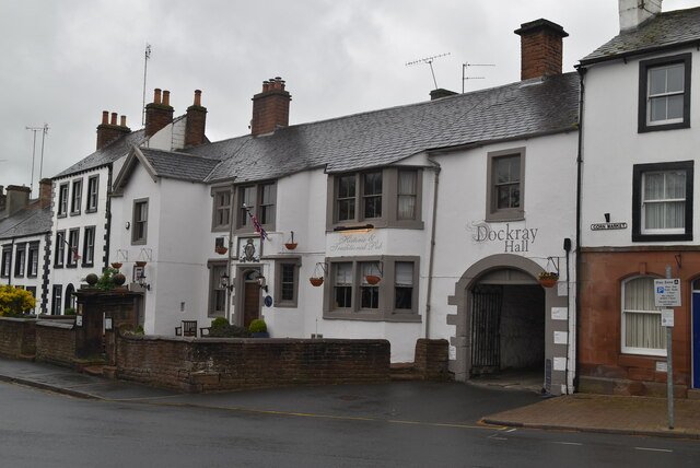
| Dockray Hall | 1312065 | I | 1470 | Great Dockray |
| Dockray Lodge | 1145090 | II | ||
| Eamont Bridge | 1145133 | I | C15th | Widened 1875. |
| Eamont Lodge | 1326940 | II | ||
| Fellside. the Flat, | 1145084 | II | ||
| Fern Bank | 1145104 | II | ||
| Former Frenchfield Farmhouse | 1145116 | II | ||
| Former Grammar School | 1145050 | II | ||
| Former Masonic Hall | 1312059 | II* | ||
| Former Outbuildings and Cattle Shed at the Rear of Frenchfield Farm | 1137840 | II | ||
| Former Salutation Hotel | 1145063 | II | ||
| Former Two Lions Public House and Integral Stables | 1312062 | II* | ||
| Former United Reformed Church | 1145089 | II | ||
| Friends' Meeting House | 1326914 | II | C17th | Former farmhouse. Meeting House Lane. |
| Gate Piers in Forecourt of the Gloucester Arms | 1145101 | II | ||
| Gate Piers to Corney House | 1326893 | II | ||
| Gate Piers to Shepherd's Hill | 1326942 | II | ||
| Gateway to Cemetery with Pair of Integral Chapels | 1145105 | II | ||
| Glen Cottage Hotel | 1326894 | II | ||
| Hill House and Coach House | 1137936 | II | ||
| Hunter House | 1326907 | II | ||
| Hutton Hall | 1326922 | II* | ||
| Infant School | 1312008 | II | ||
| Inglewood Inn Farmhouse and Integral Farm Buildings | 1145067 | II | ||
| K6 Telephone Kiosk (Outside Penrith Station) | 1145021 | II | ||
| Kitchenhill Bridge | 1145076 | II | ||
| Lark Hall | 1138212 | II | ||
| Lingstubs | 1145103 | II | ||
| Lonsdale House | 1138076 | II | ||
| Lowther Arms | 1326917 | II | ||
| Lowther Gardens | 1137877 | II* | ||
| Lowther House and Integral Barn | 1326921 | II | ||
| Magistrate's Clerks Office | 1145107 | II | ||
| Maiden Hill | 1312037 | II | ||
| Malthouse in Grounds of Shepherd's Hill | 1145062 | II* | ||
| Mansion House | 1145109 | II* | ||
| Methodist Church | 1145088 | II | 1872 | Drover Lane / Wordsworth Street |
| Methodist Church | 1145091 | II | ||
| Monument to Railway Contractors in St Andrew's Churchyard on North Side of Church | 1145049 | II | ||
| Mostyn Cottage, Mostyn Hall Cottage, and Mostyn Hall | 1312058 | II | ||
| No. 1, St Andrew's Place | 1138160 | II* | ||
| No. 1, St Andrew's View | 1326938 | II | ||
| No. 3, King Street | 1326909 | II | ||
| No. 3, Little Dockray | 1138048 | II | ||
| No. 32, King Street, | 1145074 | II | ||
| North Bank | 1145058 | II | ||
| North Friarage | 1145096 | II* | ||
| Nos. 1 and 2, St Andrew's Square | 1138179 | II | ||
| Number 7, with Attached Coach House and Stable | 1311959 | II | ||
| Outwood and Integral Stable and Coach House | 1312143 | II | ||
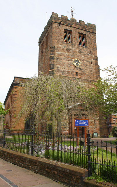
| Parish Church of St Andrew | 1145048 | I | C12th | |
| Penrith Boer War Memorial | 1446766 | II | ||
| Penrith Castle | 1138256 | I | C14th | |
| Penrith Station | 1326905 | II | 1846 | Built for the Lancaster & Carlisle Railway |
| Penrith Town Hall | 1420806 | II | ||
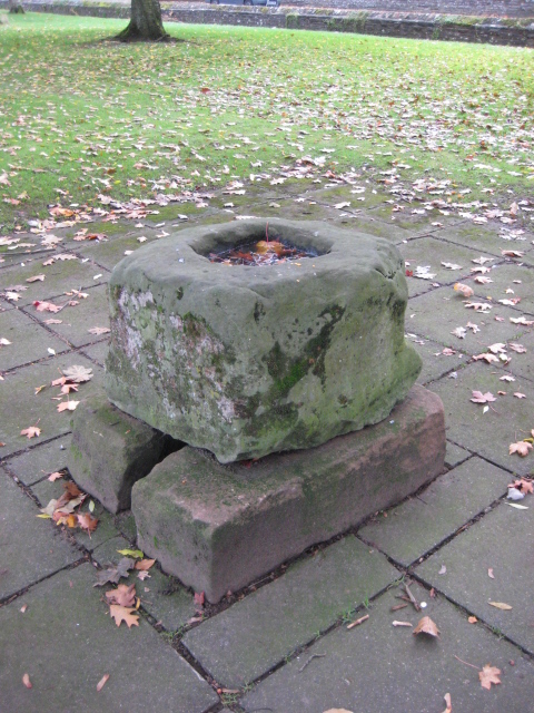
| Plague Stone in Grounds of Greengarth Old People's Home | 1137825 | II* | 1598 | Bridge Lane |
| Potters Lodge | 1145093 | II | ||
| Premises Occupied by Harrison Granger and Fairer, Solicitors | 1326937 | II | ||
| Premises Occupied by Office of Greenholme Construction Company Limited | 1326891 | II | ||
| Premises Occupied by Thornborrow, Estate Agent | 1145055 | II | ||
| Prince Albert House | 1145135 | II | ||
| Roundthorn Hotel | 1145059 | II | ||
| Rutherford House | 1145046 | II | ||
| Screen Walls of Forecourt to Mansion House | 1137823 | II | ||
| Shepherd's Hill | 1311922 | II* | ||
| Shepherd's View and Attached Barn | 1311919 | II | ||
| St Andrew's Bookshop | 1138193 | II | ||
| Stoney Beck Inn and Integral Farm Buildings | 1145066 | II | ||
| Strickland Hotel | 1137867 | II | ||
| Thacka Gate and Thacka House | 1326936 | II | ||
| The Board and Elbow Public House | 1145122 | II | ||
| The Dog Beck Public House | 1311954 | II | ||
| The Druids Arms | 1145057 | II | ||
| The Gathering | 1145054 | II* | ||
| The General Wolfe Inn | 1145077 | II | ||
| The George Hotel | 1145087 | II* | ||
| The Grey Goat Inn | 1137834 | II | ||
| The Last Orders Inn | 1137836 | II | ||
| The Vicarage | 1145092 | II | ||
| The White Horse Public House | 1145099 | II | ||
| The Woolpack Inn | 1145113 | II | ||
| Toll Bar Cottage | 1326908 | II | ||
| Tourist Information Centre | 1311984 | II* | ||
| Tudor Cottage | 1138170 | II | ||
| Tynefield House | 1311930 | II | ||
| Victoria Cottage | 1145119 | II | ||
| Virginia | 1326904 | II | ||
| War Memorial outside St Andrew's Church | 1434044 | II | ||
| Waverley Hotel | 1145073 | II | ||
| Welcome Inn with Attached Stable and Barn | 1145068 | II | ||
| Strickland's Pele Tower and Penrith Castle | 1010690 | n/a | Scheduled Monument | |
| The Giant's Thumb - Anglian high cross in St Andrew's churchyard, Penrith | 1007630 | n/a | Scheduled Monument | |
| The Giant's Grave - Two Anglian cross-shafts and four hogback stones in St Andrew's churchyard, Penrith | 1007629 | n/a | C10th | Scheduled Monument |
| Standing stone 180m NNE of Skirsgill | 1007626 | n/a | Scheduled Monument | |
| Holme Head standing stone 260m north west of Kitchenhill Bridge | 1018363 | n/a | Scheduled Monument | |
| Penrith Conservation Area | - | n/a | Conservation Area | |
| Penrith New Streets Conservation Area | - | n/a | Conservation Area |
Primary source: the National Heritage List for England - NHLE is the register of nationally protected historic buildings and sites in England, including listed buildings, scheduled monuments, protected wrecks, registered parks and gardens, and battlefields. The list is maintained by Historic England. Check NHLE for updates and new entries. Secondary sources: British Listed Buildings.
Co-Curate Page
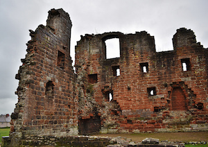
Penrith Castle
- Overview About Penrith Castle Map Street View Penrith Castle was built at the end of the 14th century by Ralph Neville (c.1364–1425) was granted the manor of Penrith in 1396. …
Co-Curate Page
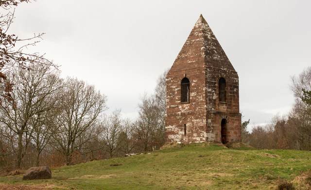
Beacon Tower
- Overview Map Street View The red sandston tower on Beacon Hill, to the north of Penrith, was built in 1719 on the site of earlier beacons. The beacon is Grade …
Co-Curate Page
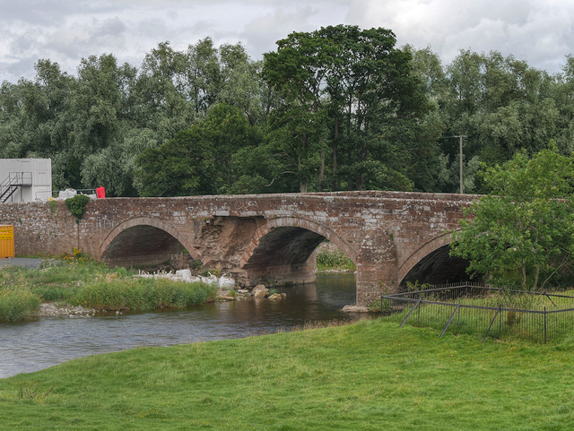
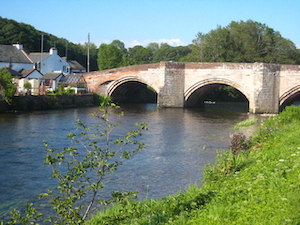
Brougham Castle Bridge
- The red sandstone bridge over the River Eamont, near Brougham Castle, was built in 1813. The bridge, near Penrith, was built to carry the Penrith-Appleby turnpike road over the River Eamont, …
Co-Curate Page
Eamont Bridge (bridge)
- Overview About Eamont Bridge Map Street View The sandstone bridge over the River Eamont at Eamont Bridge (village) dates from the c.15th century. The bridge crossed the old county boundary …
Co-Curate Page
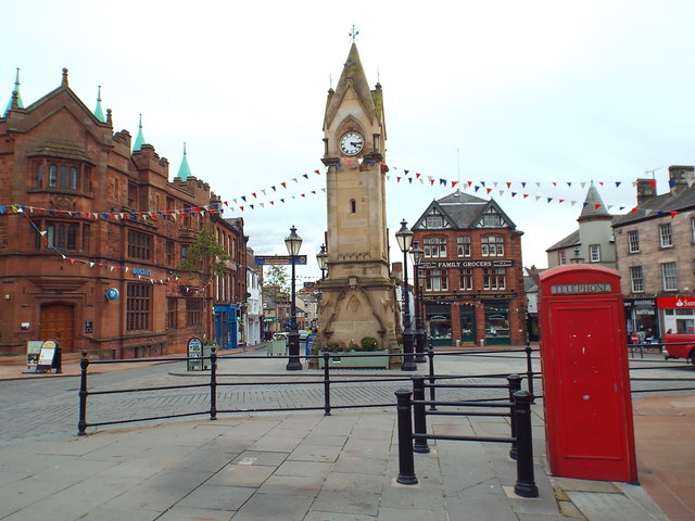
Clock Tower, Market Square
- Overview Map Street View The Clock Tower, also known as the Musgrave Monument, is located in the Market Square at Penrith. The monument is inscribed "In sympathy with the great …
Co-Curate Page
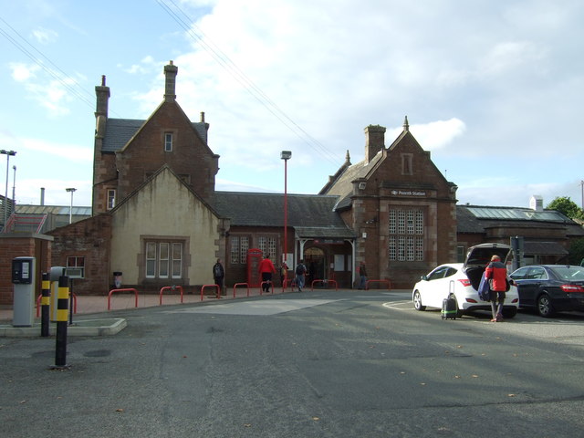
Penrith Station
- Overview About Penrith Station Map Street View Inside The railway station in Penrith, Cumbria, located off Ullswater Road, opposite the imposing ruins of Penrith Castle. The station was originally built …

Co-Curate Page
The Giant's Grave, Penrith
- A pair of 10th century Anglian cross shafts and four hogback stones, known locally as 'The Giant's Grave', is located in St Andrew's churchyard, Penrith. By local tradition, it is said …
Co-Curate Page
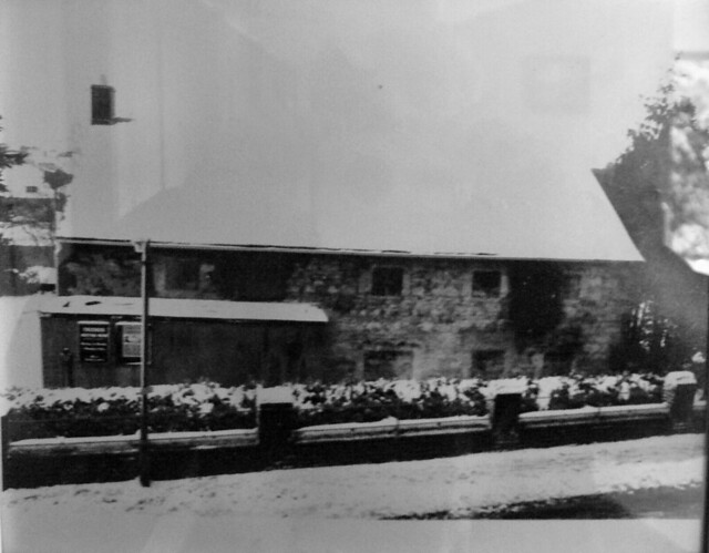
Friends' Meeting House, Penrith
- Overview Map Street View The Friends' Meeting House in Penrith is a former farmhouse which became the first dissenting place of worship in the town. In 1699, Quakers, who had …
Co-Curate Page
Plague stone, Penrith
- Overview Map Street View The Plague Stone is located beside the footpath from Bridge Lane to Tynefield Drive in Penrith. It is thought to be an old cross base, and …
Co-Curate Page
Dockray Hall, Penrith
- Overview Map Street View Dockray Hall is located on Great Dockray in Penrith. The Hall dates from c.1470, but most of the building seen today dates from the late 16th …

Co-Curate Page
Penrith Castle
- Overview About Penrith Castle Map Street View Penrith Castle was built at the end of the 14th century by Ralph Neville (c.1364–1425) was granted the manor of Penrith in 1396. …
Co-Curate Page
Beacon Tower
- Overview Map Street View The red sandston tower on Beacon Hill, to the north of Penrith, was built in 1719 on the site of earlier beacons. The beacon is Grade …
Co-Curate Page
Brougham Castle Bridge
- The red sandstone bridge over the River Eamont, near Brougham Castle, was built in 1813. The bridge, near Penrith, was built to carry the Penrith-Appleby turnpike road over the River Eamont, …
Co-Curate Page
Eamont Bridge (bridge)
- Overview About Eamont Bridge Map Street View The sandstone bridge over the River Eamont at Eamont Bridge (village) dates from the c.15th century. The bridge crossed the old county boundary …
Co-Curate Page
Clock Tower, Market Square
- Overview Map Street View The Clock Tower, also known as the Musgrave Monument, is located in the Market Square at Penrith. The monument is inscribed "In sympathy with the great …
Co-Curate Page
Penrith Station
- Overview About Penrith Station Map Street View Inside The railway station in Penrith, Cumbria, located off Ullswater Road, opposite the imposing ruins of Penrith Castle. The station was originally built …
Co-Curate Page
The Giant's Grave, Penrith
- A pair of 10th century Anglian cross shafts and four hogback stones, known locally as 'The Giant's Grave', is located in St Andrew's churchyard, Penrith. By local tradition, it is said …
Co-Curate Page
Friends' Meeting House, Penrith
- Overview Map Street View The Friends' Meeting House in Penrith is a former farmhouse which became the first dissenting place of worship in the town. In 1699, Quakers, who had …
Co-Curate Page
Plague stone, Penrith
- Overview Map Street View The Plague Stone is located beside the footpath from Bridge Lane to Tynefield Drive in Penrith. It is thought to be an old cross base, and …


