Topics > Northumberland > Civil Parishes in Northumberland > Matfen Civil Parish > Historic Buildings and Monuments in Maften Civil Parish
Historic Buildings and Monuments in Maften Civil Parish
Listed buildings and scheduled monuments in Maften Civil Parish, Northumberland, from the National Heritage List for England[1]. Use the Search (below) if looking for a specific building / monument.
| Structure | List No. | Grade | Built~ | Notes |
|---|---|---|---|---|
| Barn, Stable and Cartshed Approx 20 Yds West of South Farm | 1042750 | II | ||
| Bell, Aynsley, Stockdale and Wilkinson Headstones Approx 5 Yards South of Church of All Saints | 1042748 | II | ||
| Blackett House and Temperance Cottage | 1303470 | II | ||
| Bridge Approx 200 Yards North-East of Fenwick Shield Farmhouse | 1303524 | II | ||
| Bridge at West End of Village Green | 1042781 | II | ||
| Bridge over River Pont Approx 300 Yards South-West of Matfen Hall | 1042786 | II | ||
| Byres Attached to West of West Fenwick Farmhouse | 1155085 | II | ||
| Church of All Saints | 1042747 | II | C12th | Ryal. Partly rebuilt 1845. |
| Church of the Holy Trinity | 1042782 | II | 1842 | Matfen. By Sir Edward Blackett |
| Church View | 1155267 | II | ||
| Churchyard Wall Approx 20 Yards South of Church of the Holy Trintity | 1155240 | II | ||
| Corneyside | 1155002 | II | ||
| Dixon, Robson and 2 Other Headstones Approx 10 Yards South of Church of All Saints | 1370693 | II | ||
| Dovecote and Kennels Approx 30 Yards South West of Kennels Cottage | 1042751 | II | ||
| Drinking Fountain 20 Yards North East of Post Office | 1042784 | II | 1886 | Matfen. By the village green. |
| Dutch Barn Approx 50 Yards North of Matfen High House | 1042778 | II | ||
| East End Cottage and Attached Garden Wall | 1155201 | II | ||
| East Lodge | 1155302 | II | ||
| East Matfen Farmhouse and Attached Garden Wall | 1370707 | II | ||
| Farmbuilding at Moralees | 1303488 | II | ||
| Farmbuildings and Cottage at South Fens | 1042777 | II | ||
| Farmbuildings North of Fenwick Tower | 1155058 | II | ||
| Farmbuildings to West of East Matfen Farmhouse | 1155014 | II | ||
| Fenwick Lodge, Gatepiers and Screen Wall | 1042774 | II | ||
| Fenwick Shield Farmhouse | 1303555 | II | ||
| Fenwick Tower | 1370708 | II | ||
| Garden Wall and Gate to South of Fenwick Shield Farmhouse | 1042775 | II | ||
| Garden Wall and Privy Attached to East of South Hall | 1303497 | II | ||
| Garden Walls South of West Fenwick Farmhouse | 1370709 | II | ||
| Gates, Gatepiers and Screen Walls to West of Matfen Hall | 1042787 | II* | ||
| High House Farm Brewery | 1155124 | II | ||
| Icehouse Approx 100 Yards South-West of Kennels Cottage | 1042752 | II | ||
| Kennels Cottage | 1370695 | II | ||
| Limekiln Approx 440 Yards East of Ryal | 1042749 | II | C19th | Ryal |
| Matfen Hall | 1155328 | II* | 1836 | On site of earlier house of 1690. |
| Matfen High House | 1155107 | II | ||
| Matfen Piers | 1303577 | II | ||
| Matfen War Memorial | 1438933 | II | 1920 | |
| Milepost Pier 20 Yards West of Great Whittington Road End | 1042785 | II | C19th | Matfen |
| Muckleridge and Attached Garden Walls to South | 1370730 | II | ||
| Numbers 16 and 17 Southside | 1042783 | II | ||
| Paddock Wall South of South Hall | 1370711 | II | ||
| Pump and Trough Approx 15 Yards North of Matfen High House | 1370710 | II | ||
| South Farm | 1370694 | II | C18th | Ryal |
| South Hall | 1042779 | II* | C18th | Ingoe |
| South Wallhouses Farmhouse and Attached Outbuildings | 1042773 | II | ||
| Standing Stone | 1370696 | II | ||
| The Old Chapel | 1042780 | II | ||
| The Stob Stone | 1155462 | II | ||
| Well and Drinking Trough Approx 100 Yds South of Matfen Hall | 1370674 | II | ||
| West Fenwick Farmhouse and Former Byre Attached to West | 1042776 | II | ||
| West Lodge to Maften Hall | 1155342 | II | ||
| East Matfen medieval village and open field system | 1016351 | n/a | Medieval | Scheduled Monument |
| Hadrian's Wall and vallum between the B6321 and Sunnybrae at Halton Shields, in wall miles 18 and 19 | 1017534 | n/a | Scheduled Monument | |
| Beacon and enclosure, 175m east of Mootlaw | 1015850 | n/a | Scheduled Monument | |
| Standing stone with cup markings, 50m south of Standing Stone Farm | 1014068 | n/a | Scheduled Monument | |
| Unenclosed hut circle settlement, 180m north east of Sandyway Heads | 1014069 | n/a | Scheduled Monument | |
| Standing stone with cup markings, 230m south of Sandyway Heads | 1014070 | n/a | Scheduled Monument | |
| Round cairn, 280m SSE of Sandyway Heads | 1014071 | n/a | Scheduled Monument | |
| Round cairn, 250m south east of Low Hall | 1014072 | n/a | Scheduled Monument | |
| Hadrian's Wall and vallum between the B6309 and the B6321 in wall miles 16, 17 and 18 | 1010622 | n/a | Scheduled Monument | |
| Matfen Conservation Area | - | n/a | Conservation Area |
Primary source: the National Heritage List for England - NHLE is the register of nationally protected historic buildings and sites in England, including listed buildings, scheduled monuments, protected wrecks, registered parks and gardens, and battlefields. The list is maintained by Historic England. Check NHLE for updates and new entries. Secondary sources: British Listed Buildings and Keys to the Past.
Co-Curate Page
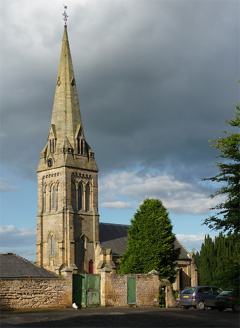
Church of the Holy Trinity
- Holy Trinity Church in Matfen was built form 1841 to 1842, designed and funded by Sir Edward Blackett of Matfen Hall. The spire was added from 1853 to 1854. It …
Co-Curate Page
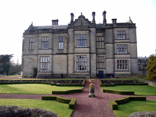
Matfen Hall
- Overview About Matfen Hall Map Street View Matfen Hall was a country house built for by Sir Edward Blackett in 1832-6 on the site of an earlier Jacobean house in …
Co-Curate Page
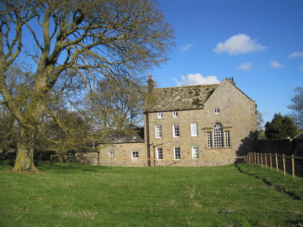
South Hall, Ingoe
- South Hall at Ingoe in Northumberland was built in the early 18th Century. It is Grade II* listed on the National Heritage List for England.
Co-Curate Page
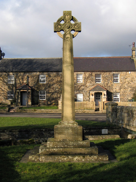
Matfen War Memorial
- Overview Map Street View The war memorial at Matfen was unveiled on the 1st of May1920 by Lt-Col. Sir Percy Wilkinson and dedicated by the vicar, Rev. H. Doudney. The …
Co-Curate Page
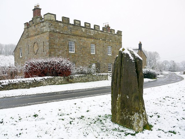
Stob Stone
- Overview Map Street View Stob Stone is a Bronze Age standing stone, located by the roadside at Standing Stone Farm, about half a mile south of Matfen in Northumberland. The …
Co-Curate Page
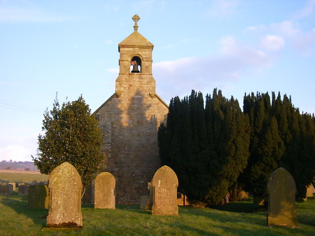
Church of All Saints, Ryal
- Overview Map Street View All Saints Church at Ryal dates from the 12th century and was previously a chapel of ease to the church at Stamfordham. The church was restored and …
Co-Curate Page
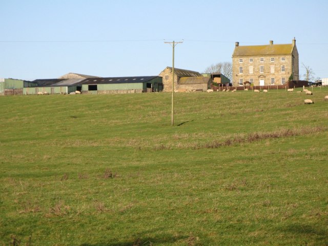
South Farm, Ryal
- Overview Map Street View The farmhouse at South Farm at Ryal was built in the 18th century. It had a staircase wing added to the rear of the building in 1771.[1] …
Co-Curate Page
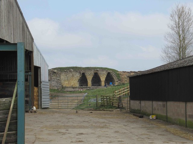
Limekiln, Ryal
- Overview Map There is an early 19th century limekiln to the east of Rydal. It is a Grade II listed structure.
Co-Curate Page
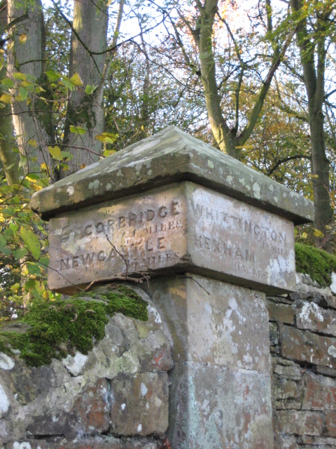
Old Milestone, B6321, Matfen
- Overview Map Street View At the west side of Matfen, on the B6321, is a C19th milepost. It is Grade II listed on the national Heritage List for England. Whittington …

Co-Curate Page
Wall Mile 18
- <Mile 17 | Mile 18 | Mile 19> Hadrian's Wall - Wall Mile 18 Hadrian's Wall stretches from the east to west coast of England and was an important frontier …
Co-Curate Page
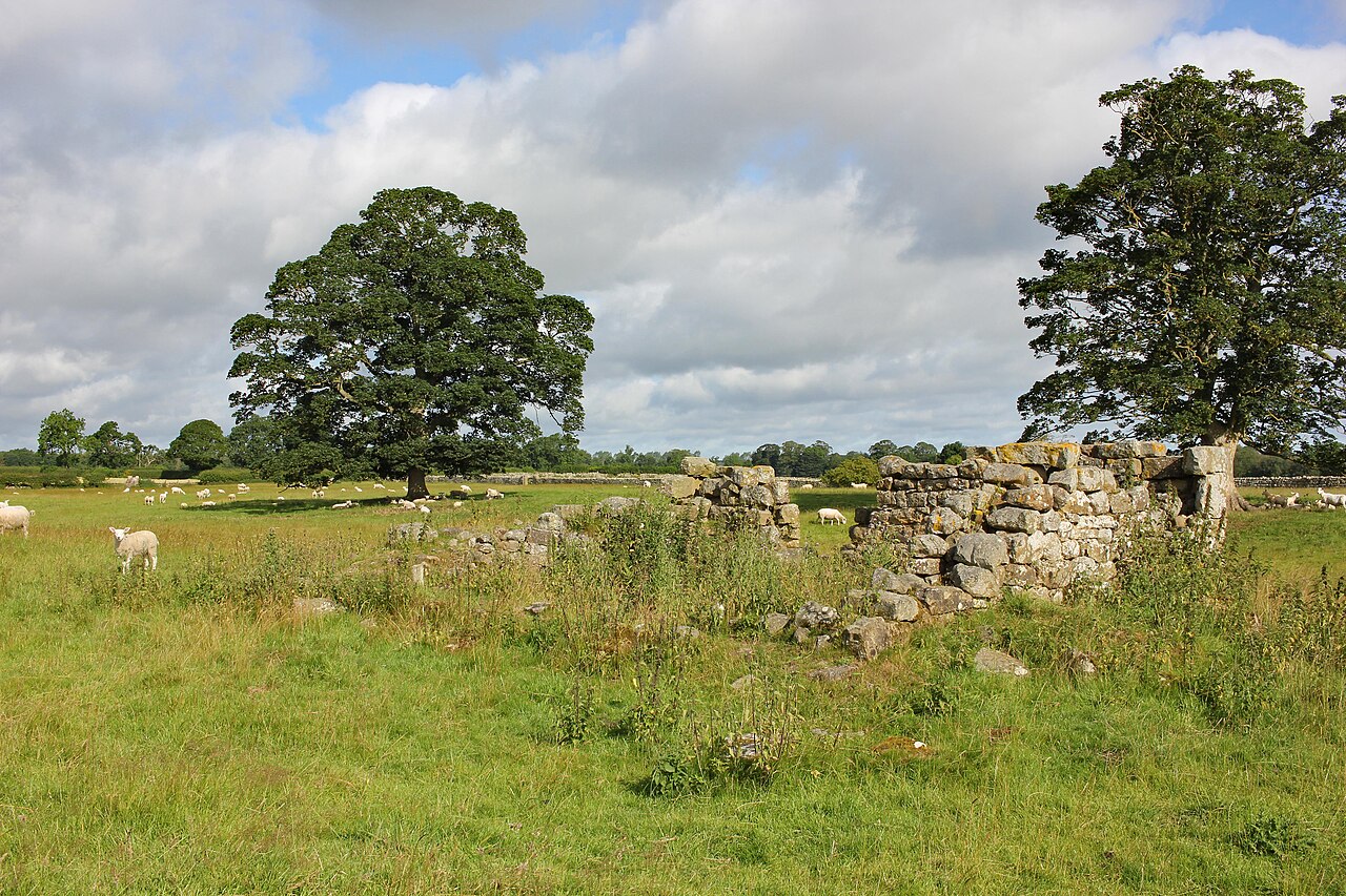
East Matfen medieval village
- Map showing the Scheduled Monument area of East Matfen medieval village, with Matfen to the west. The site of East Matfen medieval village is located about a mile ESE of …

Co-Curate Page
Church of the Holy Trinity
- Holy Trinity Church in Matfen was built form 1841 to 1842, designed and funded by Sir Edward Blackett of Matfen Hall. The spire was added from 1853 to 1854. It …
Co-Curate Page
Matfen Hall
- Overview About Matfen Hall Map Street View Matfen Hall was a country house built for by Sir Edward Blackett in 1832-6 on the site of an earlier Jacobean house in …
Co-Curate Page
South Hall, Ingoe
- South Hall at Ingoe in Northumberland was built in the early 18th Century. It is Grade II* listed on the National Heritage List for England.
Co-Curate Page
Matfen War Memorial
- Overview Map Street View The war memorial at Matfen was unveiled on the 1st of May1920 by Lt-Col. Sir Percy Wilkinson and dedicated by the vicar, Rev. H. Doudney. The …
Co-Curate Page
Stob Stone
- Overview Map Street View Stob Stone is a Bronze Age standing stone, located by the roadside at Standing Stone Farm, about half a mile south of Matfen in Northumberland. The …
Co-Curate Page
Church of All Saints, Ryal
- Overview Map Street View All Saints Church at Ryal dates from the 12th century and was previously a chapel of ease to the church at Stamfordham. The church was restored and …
Co-Curate Page
South Farm, Ryal
- Overview Map Street View The farmhouse at South Farm at Ryal was built in the 18th century. It had a staircase wing added to the rear of the building in 1771.[1] …
Co-Curate Page
Limekiln, Ryal
- Overview Map There is an early 19th century limekiln to the east of Rydal. It is a Grade II listed structure.
Co-Curate Page
Old Milestone, B6321, Matfen
- Overview Map Street View At the west side of Matfen, on the B6321, is a C19th milepost. It is Grade II listed on the national Heritage List for England. Whittington …
Co-Curate Page
Wall Mile 18
- <Mile 17 | Mile 18 | Mile 19> Hadrian's Wall - Wall Mile 18 Hadrian's Wall stretches from the east to west coast of England and was an important frontier …


