Topics > Northumberland > Civil Parishes in Northumberland > Ilderton Civil Parish > Historic Buildings and Monuments in Ilderton Civil Parish
Historic Buildings and Monuments in Ilderton Civil Parish
Listed buildings and scheduled monuments in Ilderton Civil Parish, Northumberland, from the National Heritage List for England[1]. Use the Search (below) if looking for a specific building / monument.
| Structure | List No. | Grade | Built~ | Notes |
|---|---|---|---|---|
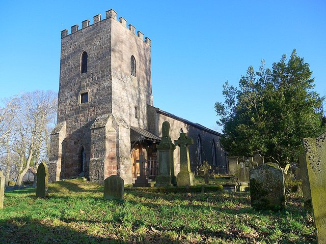
| Church of St Michael | 1370929 | II* | C13th | Ilderton. Gothicized in C19th |
| Ilderton Hall | 1042357 | II | ||
| Lilburn West Bridge | 1233053 | II | ||
| Milepost Circa 3/4 Mile South of Surrey House | 1370928 | II | ||
| Monument to Thomas Wallar(?) Circa 10 Yards South of Church of St Michael | 1304285 | II | ||
| North Middleton House | 1153510 | II | c.1830 | North Middleton |
| Pair of Gravestones to Crea and Archbold Circa 15 Yards South of Church of St Michael | 1153481 | II | ||
| Roddam Mausoleum Circa 30 Yards East of Church of St Michael | 1042356 | II | ||
| Stable and Carriage House Circa 80 Yards North of Ilderton Vicarage | 1153503 | II | ||
| Threestoneburn House | 1370890 | II | ||
| Unenclosed hut circle settlement 1060m north west of Ilderton Moor | 1019930 | n/a | Scheduled Monument | |
| Prehistoric rock art 190m south west of Middleton Dean promontory fort | 1417675 | n/a | Scheduled Monument | |
| South Ringles Roman period native settlement 850m north west of Middleton Dean | 1014924 | n/a | Scheduled Monument | |
| Round cairn 435m south west of Langlee | 1014926 | n/a | Scheduled Monument | |
| Medieval shieling and enclosure 330m south west of Langlee | 1014927 | n/a | Scheduled Monument | |
| The Ringles defended settlement 1025m north west of Middleton Dean | 1014931 | n/a | Scheduled Monument | |
| Unenclosed hut circle settlement and field plots east of Rackside, 450m south west of Cowboy's Cairn | 1016709 | n/a | Scheduled Monument | |
| Two prehistoric hut circles and field enclosure 560m south west of Cowboy's Cairn | 1016941 | n/a | Prehistoric | Scheduled Monument |
| North Middleton medieval village | 1018022 | n/a | Scheduled Monument | |
| Iron Age defended settlement 740m south east of South Middleton | 1018067 | n/a | Scheduled Monument | |
| Medieval shieling 600m south east of South Middleton | 1018350 | n/a | Scheduled Monument | |
| Long cairn on the south western slope of Dod Hill, 1km north east of The Dod | 1019417 | n/a | Scheduled Monument | |
| Three round cairns on the summit of Dod Hill | 1019418 | n/a | Scheduled Monument | |
| Romano-British farmstead on the eastern slope of Dod Hill, 1km north of The Dod | 1019419 | n/a | Scheduled Monument | |
| Promontory fort 330m south east of Middleton Dean | 1019420 | n/a | Scheduled Monument | |
| Round cairn on the southern slope of Dod Hill, 800m NNE of The Dod | 1019868 | n/a | Scheduled Monument | |
| Round cairn cemetery 1000m north west of Heddon Hill | 1019920 | n/a | Scheduled Monument | |
| Cairnfield 400m north of Threestoneburn House | 1019921 | n/a | Scheduled Monument | |
| Stone circle and stone alignment 370m west of Threestoneburn House | 1019922 | n/a | Scheduled Monument | |
| Round cairn 850m, and two Romano-British farmsteads, associated trackway, moated site, medieval settlement and field system 900m SSE of Middleton Dean | 1019923 | n/a | Scheduled Monument | |
| Hut circle 320m west of Threestoneburn House | 1019924 | n/a | Scheduled Monument | |
| Unenclosed hut circle settlement and part of a field system, 880m north of Heddon Hill | 1019931 | n/a | Scheduled Monument | |
| Round cairn on the summit of Heddon Hill | 1019932 | n/a | Scheduled Monument | |
| Defended settlement 900m west of Calder | 1019933 | n/a | Scheduled Monument | |
| Three Romano-British farmsteads and part of a field system on Heddon Hill 900m north west of Calder | 1019934 | n/a | Scheduled Monument | |
| Settlement 470m north east of Heddon Hill | 1020558 | n/a | Scheduled Monument | |
| Enclosed settlement on east slope of Brands Hill, 900m north of Cowboy's Cairn | 1015633 | n/a | Scheduled Monument | |
| Enclosed settlement and subsidiary enclosure on east slope of Brands Hill, 700m south west of the south western edge of Broom Crook Plantation | 1015634 | n/a | Scheduled Monument | |
| Bronze Age cairnfield and cup and ring marked stone 550m north west of Middleton Dean | 1015640 | n/a | Scheduled Monument | |
| Roman period native settlement on the south east slopes of Brands Hill, 430m north west of Cowboy's Cairn | 1015642 | n/a | Scheduled Monument | |
| Roman period native enclosed settlement and scooped enclosure on the south east slopes of Brands Hill, 350m north west of Cowboy's Cairn | 1015643 | n/a | Scheduled Monument | |
| Roman period native scooped enclosure, 930m north east of Langlee | 1016139 | n/a | Scheduled Monument | |
| Unenclosed Bronze Age hut circle and clearance cairn 800m ESE of Langlee | 1016140 | n/a | Scheduled Monument | |
| Prehistoric enclosure south west of Brands Hill and 870m east of Langlee | 1016141 | n/a | Scheduled Monument | |
| Bronze Age unenclosed settlement and field system with burial cairns south west of Brands Hill, 350m ENE of Langlee | 1016142 | n/a | Scheduled Monument | |
| Roman period native settlements, field system and medieval shieling on the east slope of Brands Hill, 550m west of Middleton Old Town | 1016238 | n/a | Scheduled Monument | |
| Prehistoric enclosure, associated field system, cairnfield, round houses and medieval shielings on E and SE slopes of Brands Hill | 1016239 | n/a | Scheduled Monument | |
| Prehistoric cairnfield and unenclosed settlement, Romano-British village and field system and medieval field system on north east slopes of Brands Hill | 1016240 | n/a | Scheduled Monument | |
| Roman period native settlement and associated field system and trackway on north east slope of Brands Hill | 1016241 | n/a | Scheduled Monument | |
| Two Bronze Age round cairns and enclosed cremation cemetery 825m north west of Middleton Dean | 1016242 | n/a | Scheduled Monument | |
| Roman period native settlement and medieval shieling on east slopes of Brands Hill, 1100m south east of Carey Burn Bridge | 1016244 | n/a | Scheduled Monument | |
| Prehistoric enclosures, Bronze Age field system, unenclosed round houses and three cairns NW of Langlee Crags, 900m south of Langlee | 1016245 | n/a | Scheduled Monument | |
| Prehistoric unenclosed hut circle and field plot at Lamb Crag | 1016247 | n/a | Scheduled Monument | |
| Round cairn 790m west of Smithy Strip | 1016248 | n/a | Scheduled Monument | |
| Settlements SE of Heddon Hill | 1006443 | n/a | Scheduled Monument |
Primary source: the National Heritage List for England - NHLE is the register of nationally protected historic buildings and sites in England, including listed buildings, scheduled monuments, protected wrecks, registered parks and gardens, and battlefields. The list is maintained by Historic England. Check NHLE for updates and new entries.
Secondary sources: British Listed Buildings and Keys to the Past.

Co-Curate Page
Prehistoric hut circles and field enclosure SW of Cowboy's Cairn
- Scheduled Monument areas - based on Historic England data (Open Government Licence). This site, about 3½ miles WNW of the village of Ilderton, has the archaeological remains two prehistoric hut …


