Topics > Northumberland > Civil Parishes in Northumberland > Denwick Civil Parish > Historic Buildings and Monuments in Denwick Civil Parish
Historic Buildings and Monuments in Denwick Civil Parish
Listed buildings and scheduled monuments in Denwick Civil Parish, Northumberland, from the National Heritage List for England[1]. In the absence of a published 'local list', some other public buildings of interest may also be included. Use the Search (below) if looking for a specific building / monument.
| Structure | List No. | Grade | Built~ | Notes |
|---|---|---|---|---|
| Nos. 1, 3 and 5, Denwick Village | 1153547 | II | ||
| 10 Boundary Stones on Parish Boundary with Denwick (Detached) Civil Parish | 1054003 | II | ||
| Nos. 11 and 13, Denwick Village | 1304233 | II | ||
| Nos. 17 and 19, Denwick Village | 1042047 | II | ||
| 2 Boundary Stones on Boundary with Alnwick Civil Parish | 1371050 | II | ||
| Nos. 21 and 23, Denwick Village | 1304237 | II | ||
| 4 Boundary Stones on Boundary with Newton on the Moor Civil Parish | 1051072 | II | ||
| Nos. 7 and 9, Denwick Village | 1042046 | II | ||
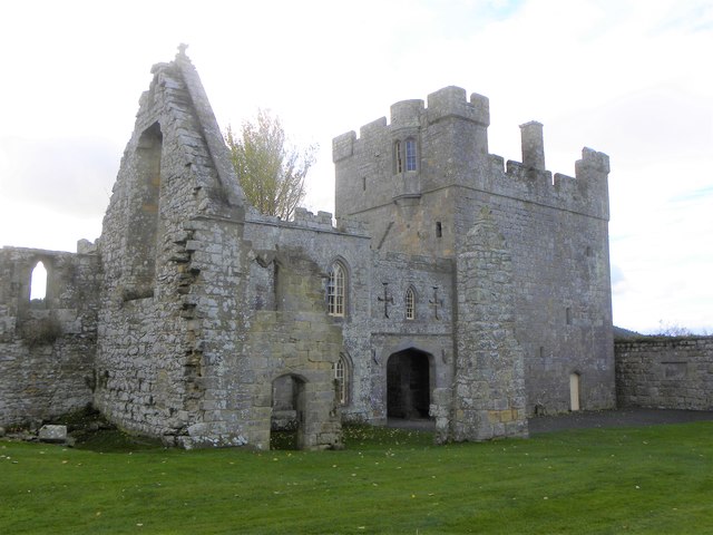
| Alnwick Abbey Gatehouse | 1042051 | I | C14th | Hulne Park |
| Barn and Gingang to North West of White House Folly Farmhouse | 1051095 | II | ||
| Brizlee Tower | 1076985 | I | 1781 | Hulne Park |
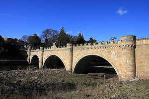
| Denwick Bridge over River Aln | 1042043 | I | 1766 | Also listed as 1371329 |
| Denwick House | 1042049 | II | ||
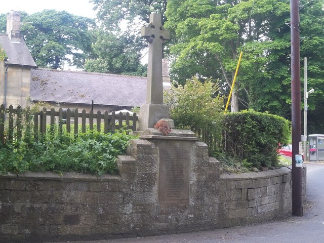
| Denwick War Memorial | 1433767 | II | 1920 | |
| Dovecote to East of Heckley Fence Farmhouse with Attached Wall | 1371059 | II | C18th | Heckley |
| Farmbuilding Group at East Brizlee with Attached Walls | 1042053 | II | ||
| Farmbuilding Group North West of Rugley Farmhouse | 1042022 | II | C19th | Rugley |
| Farmbuildings with Attached Walls South West of Greensfield Farmhouse | 1371049 | II | ||
| Friars Well 50 Metres West of Friars Well Lodge | 1342740 | II | ||
| Front Walls and Gatepiers to Numbers 1-23 (Odd) | 1042048 | II | ||
| Garden Walls and Gate to West of Park Farmhouse | 1371085 | II | ||
| Greensfield Farmhouse with Attached Wall to North | 1042020 | II | ||
| Greensfield Moor Farmhouse | 1042019 | II | C18th | |
| Heckley High House Farmhouse with Adjacent Outbuilding to West | 1067717 | II | c.1810 | Heckley |
| Heckley House | 1042044 | II | C18th | Heckley |
| Heiferlaw Tower | 1304282 | I | C15th | |
| Hulne Friary Curtain Wall and Attached Structure | 1042012 | I | C15th | Hulne Priory |
| Hulne Friary Infirmary | 1042011 | II* | C13th | Hulne Priory |
| Hulne Friary Summerhouse and Tower | 1049118 | I | 1488 | Hulne Priory (Summerhouse C18th) |
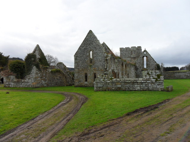
| Hulne Friary; Ruins of Church and Claustral Buildings | 1042054 | I | C13th | Hulne Priory |
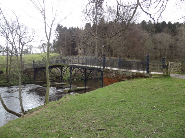
| Iron Bridge over River Aln | 1042013 | II* | 1812 | Hulne Park |
| Islaford Bridge Carrying Humbleheugh Track over White House Burn | 1042018 | II | ||
| Ladys Well on East Side of Ladys Well Drive | 1371083 | II | ||
| Limekiln 100 Metres South of Road 650 Metres West of Old Rugley | 1052367 | II | C19th | |
| Lodge at Park Entrance 100 Metres East of Alnwick Abbey Gatehouse | 1076976 | II | ||
| Main Farmbuilding Group to North of Park Farmhouse | 1049065 | II | ||
| Malcolm's Cross and Remains of Older Cross on West | 1153333 | II | 1774 | B6341 |
| Milepost 100 Metres East of Shipley Bridge | 1371060 | II | ||
| Milepost 130 Metres South of Blackbog Burn Bridge | 1042045 | II | ||
| Milepost 180 Metres North of Abbey Cottage | 1153515 | II | ||
| Milepost 300 Metres East of White House Burn Bridge | 1304251 | II | ||
| Milepost 380 Metres North of Denwick Bridge End | 1153391 | II | ||
| Milepost 40 Metres North of Entrance to Heckley House | 1153486 | II | C19th | Heckley |
| Milepost 420 Metres North of Track to Heckley Fence | 1304291 | II | C19th | Heckley |
| Milepost 80 Metres South of Broom House Roundabout | 1042041 | II | C19th | B6341, Broomhouse |
| Milepost on East Side of Old A1 210 Metres North of Cawledge Bridge | 1372898 | II | ||
| Moor Lodge and Attached Screen Wall | 1042014 | II | ||
| Outbuilding Range to North of Greensfield Farmhouse | 1051081 | II | ||
| Outer Precinct Wall to East and North of Hulne Friary | 1371082 | II | Hulne Priory | |
| Pair of Limekilns 350 Metres North West of Hobberlaw | 1051083 | II | C19th | Hobberlaw |
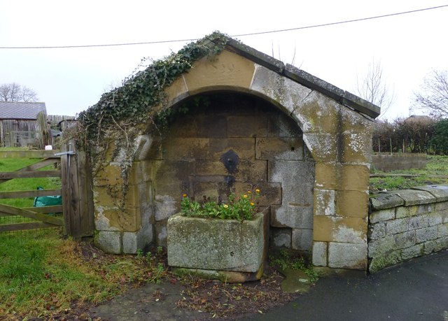
| Pant 50 Metres East of Village Hall | 1067776 | II | 1859 | Denwick |
| Pant and Adjacent Walls 30 Metres South West of Road Junction in Centre of Village | 1042050 | II | ||
| Park Farmhouse | 1042016 | II | ||
| Remains of White Cross 400 Metres North East of Denwick Bridge | 1042042 | II | ||
| Ruins of St Leonard's Hospital | 1371058 | II | C13th | |
| Shelter Shed 30 Metres South of Greenfield Farmhouse | 1042021 | II | ||
| Shelter Shed Block 40 Metres South West of Park Farmhouse | 1042017 | II | ||
| South Part of Farmbuilding Range 20 Metres North East of Humbleheugh Farmhouse | 1051087 | II | ||
| Statue at Entrance to Nine Year Aud Hole on North of Cave Drive 250 Metres South West of Brizlee Tow | 1042015 | II | ||
| The Lion Bridge over River Aln | 1304367 | I | 1775 | Partly in Denwick, partly in Alnwick. |
| West Brizlee; Shelter Shed on East of Old Farmhouse | 1049051 | II | ||
| White Well 120 Metres North of Alnwick Abbey Gatehouse | 1042052 | II | ||
| Alnwick Castle - grounds | 1001041 | I | C18th | Listed Park & garden. Partly in this parish. Includes Hulne Park. |
| St Leonard's Hospital, Alnwick | 1006595 | n/a | C13th | Scheduled Monument |
| Alnwick Abbey | 1006598 | n/a | Scheduled Monument | |
| Hulne Priory | 1002904 | n/a | Scheduled Monument | |
| Heiferlaw tower house, 230m north east of Holywell | 1014061 | n/a | Scheduled Monument | |
| Standing stone, 550m south west of White House | 1014062 | n/a | Scheduled Monument | |
| Defended settlement, 620m SSW of West Brizlee | 1014066 | n/a | Scheduled Monument | |
| Defended settlement, 300m WNW of West Brizlee | 1014067 | n/a | Scheduled Monument | |
| Defended settlement, 100m north west of Chester Cottage | 1014073 | n/a | Scheduled Monument | |
| Heiferlaw defended settlement and Second World War Zero Station, 100m north of Holywell | 1014080 | n/a | Scheduled Monument | |
| Lion Bridge | 1006568 | n/a | Scheduled Monument. Part in this parish, part in Alnwick. | |
| Pillobox | not listed | n/a | c.1941 | Heiferlaw |
Primary source: the National Heritage List for England - NHLE is the register of nationally protected historic buildings and sites in England, including listed buildings, scheduled monuments, protected wrecks, registered parks and gardens, and battlefields. The list is maintained by Historic England. Check NHLE for updates and new entries. Secondary sources: British Listed Buildings and Keys to the Past.
Co-Curate Page
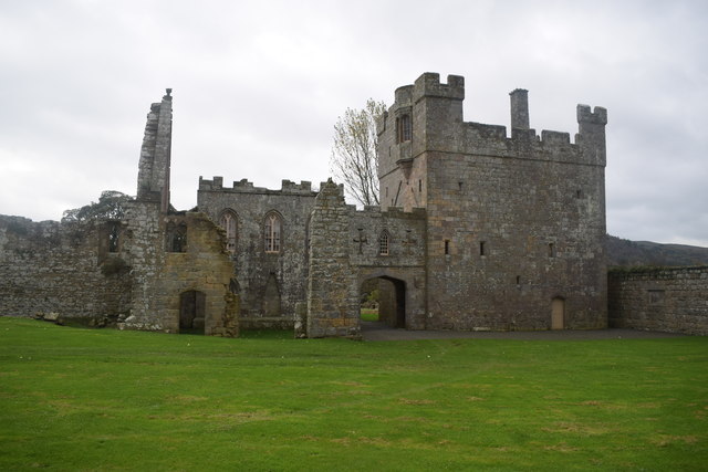
Alnwick Abbey
- Overview About Alnwick Abbey Map Street View Alnwick Abbey was founded as a Premonstratensian monastery in 1147 by Eustace fitz John near Alnwick, England, as a daughter house of …
Co-Curate Page
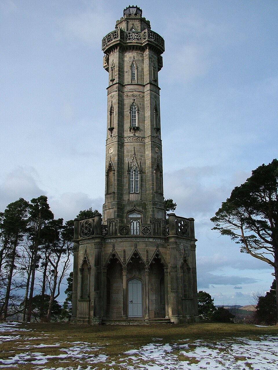
Brizlee Tower
- Overview About Brizlee Tower Map Brizlee Tower is located about 2 miles north-west of Alnwick, situated on a hill top, overlooking Hulne Park. The ornamental tower was built in 1781 for …
Co-Curate Page
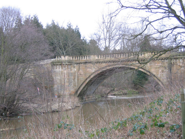
Denwick Bridge
- Overview Map Street View Denwick Bridge over the River Aln is located about half a mile north east of Alnwick and a similar distance south west of Denwick. The stone …
Co-Curate Page
Heiferlaw Tower
- Heiferlaw Tower was a lookout tower for Alnwick Abbey, built in the late 15th century. It is a large squared stone 3 story and roofless tower. The tower has a …
Co-Curate Page
The Lion Bridge
- Overview Map Street View The Lion Bridge over the River Aln at Alnwick was built in 1775 by John Adam.[1] The stone bridge has 4 arches and in the centre of …
Co-Curate Page
War Memorial, Denwick
- Overview Map Street View The war memorial in Denwick was unveiled on the 14th of November 1920 by the Duke of Northumberland. It was dedicated by Canon Mangin, Vicar of …
Co-Curate Page
Pant near Village Hall, Denwick
- Overview Map Street View This pant (covered water supply) in Denwick was built in 1859. It is Grade II listed.
Co-Curate Page
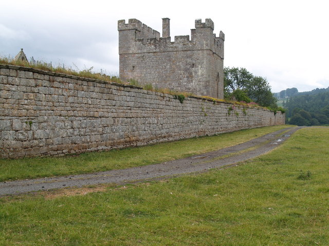
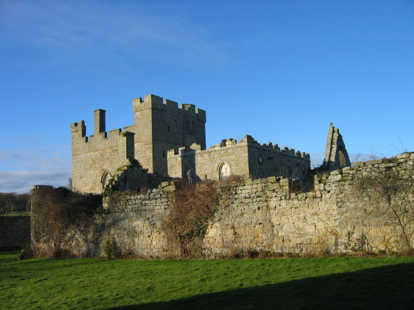
Hulne Priory
- Hulne Priory (also known as Hulne Friary or Hulne Abbey) is located about 1½mile north-west of Alnwick, in Northumberland. It is the best preserved and probably the earliest Carmelite friary …
Co-Curate Page
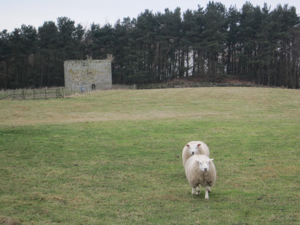
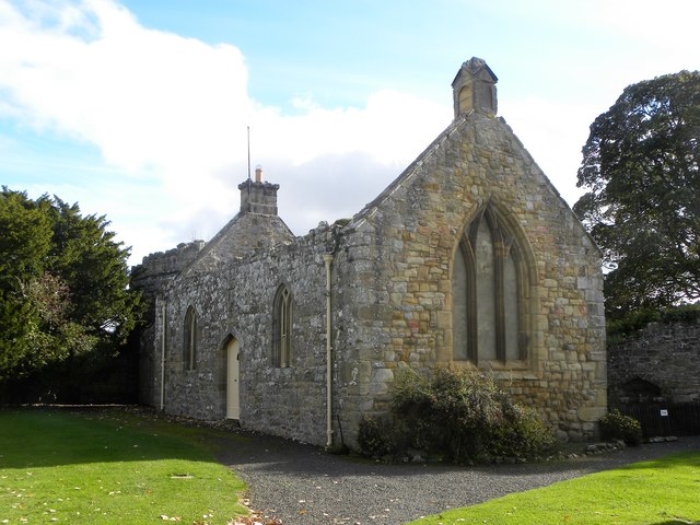
St Leonard's Hospital (ruins), Denwick
- Overview Map Street View The remains of the medieval St Leonard's Hospital are beside the B6341 road, about ¾ mile north of Alnwick and a mile west of the village of …
Co-Curate Page
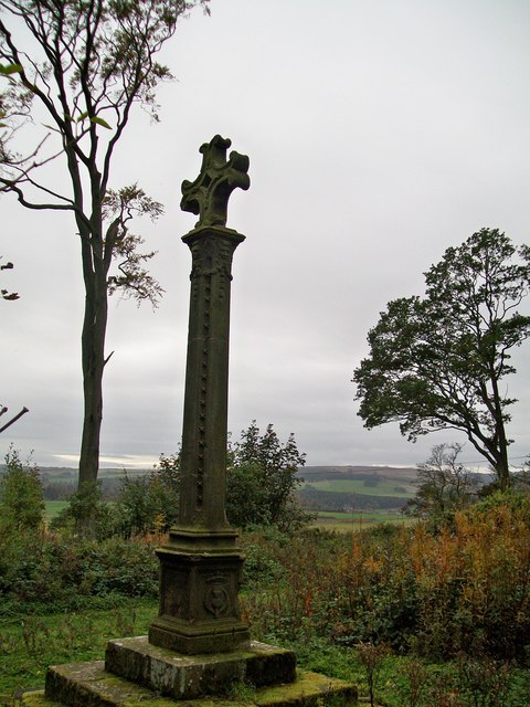
Malcolm's Cross
- Overview Map Street View Malcolm's Cross is located about ¾mile north of Alnwick, in woods by the B6341 road, just south of the Broomhouse Roundabout. The cross was erected at …

Co-Curate Page
Old Milepost south of Broomhouse Roundabout
- Overview Map Street View Milepost by the B6341 (the old A1 Great North Road) at Broomhouse, about 1 mile north of Alnwick. The milepost was erected in the mid-19th century …
Co-Curate Page
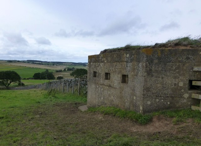
Pillbox, Heiferlaw
- This pillbox is on the northern slopes of Heiferlaw. It was built during the Second World War as part of the Wooler to Alnwick Stop Line. It is a Polygonal …

Co-Curate Page
Limekiln west of Old Rugley
- This old limekiln is located on Alnwick Moor between Old Rugley and Hadwin's Close. A disused quarry (presumably limestone) is shown nearby on OS maps. The limekiln dates from the …

Co-Curate Page
Greensfield Moor Farm (Denwick)
- Overview Map Street View Greensfield Moor Farm is located off the A1 about 1 mile south of Alnwick town centre. It is situated to the north of Cawledge Burn. The …

Co-Curate Page
Lime Kilns, Hobberlaw
- Overview Map There are a pair of lime kilns located to the north-west of Hobberlaw and south-west of High Hobberlaw. They probably date from the 19th century, with the eastern …

Co-Curate Page
Alnwick Abbey
- Overview About Alnwick Abbey Map Street View Alnwick Abbey was founded as a Premonstratensian monastery in 1147 by Eustace fitz John near Alnwick, England, as a daughter house of …
Co-Curate Page
Brizlee Tower
- Overview About Brizlee Tower Map Brizlee Tower is located about 2 miles north-west of Alnwick, situated on a hill top, overlooking Hulne Park. The ornamental tower was built in 1781 for …
Co-Curate Page
Denwick Bridge
- Overview Map Street View Denwick Bridge over the River Aln is located about half a mile north east of Alnwick and a similar distance south west of Denwick. The stone …
Co-Curate Page
Heiferlaw Tower
- Heiferlaw Tower was a lookout tower for Alnwick Abbey, built in the late 15th century. It is a large squared stone 3 story and roofless tower. The tower has a …
Co-Curate Page
The Lion Bridge
- Overview Map Street View The Lion Bridge over the River Aln at Alnwick was built in 1775 by John Adam.[1] The stone bridge has 4 arches and in the centre of …
Co-Curate Page
War Memorial, Denwick
- Overview Map Street View The war memorial in Denwick was unveiled on the 14th of November 1920 by the Duke of Northumberland. It was dedicated by Canon Mangin, Vicar of …
Co-Curate Page
Pant near Village Hall, Denwick
- Overview Map Street View This pant (covered water supply) in Denwick was built in 1859. It is Grade II listed.
Co-Curate Page
Hulne Priory
- Hulne Priory (also known as Hulne Friary or Hulne Abbey) is located about 1½mile north-west of Alnwick, in Northumberland. It is the best preserved and probably the earliest Carmelite friary …
Co-Curate Page
St Leonard's Hospital (ruins), Denwick
- Overview Map Street View The remains of the medieval St Leonard's Hospital are beside the B6341 road, about ¾ mile north of Alnwick and a mile west of the village of …
Co-Curate Page
Malcolm's Cross
- Overview Map Street View Malcolm's Cross is located about ¾mile north of Alnwick, in woods by the B6341 road, just south of the Broomhouse Roundabout. The cross was erected at …
Co-Curate Page
Old Milepost south of Broomhouse Roundabout
- Overview Map Street View Milepost by the B6341 (the old A1 Great North Road) at Broomhouse, about 1 mile north of Alnwick. The milepost was erected in the mid-19th century …
Co-Curate Page
Pillbox, Heiferlaw
- This pillbox is on the northern slopes of Heiferlaw. It was built during the Second World War as part of the Wooler to Alnwick Stop Line. It is a Polygonal …
Co-Curate Page
Limekiln west of Old Rugley
- This old limekiln is located on Alnwick Moor between Old Rugley and Hadwin's Close. A disused quarry (presumably limestone) is shown nearby on OS maps. The limekiln dates from the …
Co-Curate Page
Greensfield Moor Farm (Denwick)
- Overview Map Street View Greensfield Moor Farm is located off the A1 about 1 mile south of Alnwick town centre. It is situated to the north of Cawledge Burn. The …


