Topics > Northumberland > Kirkhaugh > Kirkhaugh Roman Bridge Abutments
Kirkhaugh Roman Bridge Abutments
Scheduled Monument (#1006577): Kirkhaugh Bridge abutments 1/2 mile (800m) NE of Whitley Castle
Click the headings below to expand (selected extracts from the Historic England scheduling)
Roman bridges are very rare nationally with fewer than 25 recorded examples remaining. The footings of the south west bridge abutment of the Kirkhaugh Roman bridge is preserved. The bridge is an integral part of an important Roman landscape. The bridge carried a Roman road from Corbridge to Whitley Castle Roman fort and vicus, which lies 730m to the south west. The route of the Maiden Way Roman road runs NNW-SSE close to the east of the bridge abutment.
The Kirkhaugh Roman bridge abutments north east of Whitley Castle and the ground beneath it will contain archaeological deposits relating to its construction and use, including important dating evidence. The monument provides insight into the Roman occupation of Britain and the need to create and control major route ways.
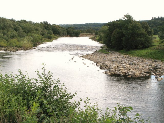
The monument includes the remains of the abutment of a bridge of Roman date, situated on the south west bank of the River South Tyne. The abutment is built of large roughly dressed stones with a rubble core and hammer-dressed quoins. The remains of the abutment stand to a height of up to five courses and measure approximately 5.9m at its widest point.
Since the bridge was built the River South Tyne has altered its course north eastwards, which has destroyed the north east abutment of the bridge and left the south west abutment on dry ground approximately 24m from the river’s present course. The abutment of the bridge is on the line of the Roman road which is thought to have stretched between Whitley Castle Roman fort and Corbridge. A slight, low linear earthwork links the location of the bridge to Whitley Castle.

from https://historicengland.org.u…
Kirkhaugh Bridge abutments 1/2 mile (800m) NE of Whitley Castle
- A bridge is a timber or masonry structure designed to carry a road or path over a waterway. There are a number of ways of identifying the sites of former …
Added by
Simon Cotterill

Co-Curate Page
Whitley Castle Roman Fort (Epiacum)
- Overview Street View Map of Whitley Castle Roman fort (Epiacum) - Scheduled Monument Area The remains of Epiacum Roman Fort are located about 1½ miles north-west of Alston. The fort …

from https://historicengland.org.u…
Kirkhaugh Bridge abutments 1/2 mile (800m) NE of Whitley Castle
- A bridge is a timber or masonry structure designed to carry a road or path over a waterway. There are a number of ways of identifying the sites of former …
Added by
Simon Cotterill