Topics > Civil Parishes in Cumbria > Waterhead Civil Parish > Historic Buildings and Monuments in Waterhead Civil Parish
Historic Buildings and Monuments in Waterhead Civil Parish
Listed buildings and scheduled monuments in Waterhead Civil Parish, Cumbria, from the National Heritage List for England[1]. In the absence of a published 'local list', some other public buildings of interest may also be included. Use the Search (below) if looking for a specific building / monument.
| Structure | List No. | Grade | Built~ | Note |
|---|---|---|---|---|
| Birdoswald Farmhouse | 1249314 | II | 1858 | |
| Farmbuildings Situated 30 Metres North North West of Birdoswald Farmhouse or Tenement | 1335607 | II | c.1858 | |
| High House and Adjoining Barn | 1087514 | II | 1677 | |
| Lanerton | 1087515 | II | ||
| Northrigghill | 1205626 | II | 1836 | Farmhouse |
| Orchard House | 1205641 | II | ||
| Spa Villa | 1087517 | II | 1815 | Glisland Spa |
| The Hill | 1087516 | II | C18th | House |
| Maiden Way Roman road from B6318 to 450m SW of High House, Gillalees Beacon signal station and Beacon Pasture early post-medieval dispersed settlement | 1018242 | n/a | Scheduled Monument. Partly in this parish. | |
| Birdoswald Roman fort and the section of Hadrian's Wall and vallum between the River Irthing and the field boundaries east of milecastle 50 | 1010994 | n/a | Roman | Scheduled Monument |
| Hadrian's Wall and vallum between the field boundaries east of milecastle 50 and the boundary west of Coombe Crag in wall miles 50 and 51 | 1010995 | n/a | Roman | Scheduled Monument |
| Romano-British farmstead and post-medieval farmstead at Watch Hill | 1013968 | n/a | Scheduled Monument | |
| Eight Roman inscriptions in the Roman quarry in Combcrag Wood, 350m south of Hadrian's Wall | 1014581 | n/a | Scheduled Monument | |
| Enclosure castle known as Triermain Castle | 1014876 | n/a | C14th? | Scheduled Monument |
| Hadrian's Wall and vallum between the field boundary west of Coombe Crag and Banks Green Cottage and the road to Lanercost at Banks in wall miles 51 and 52 | 1010996 | n/a | Scheduled Monument | |
| Hadrian's Wall and vallum and their associated features between Poltross Burn and the River Irthing in wall mile 48 | 1015923 | n/a | Scheduled Monument | |
| Old lime kiln south of Northrigg Hill | not listed | n/a | C19th |
Primary source: the National Heritage List for England - NHLE is the register of nationally protected historic buildings and sites in England, including listed buildings, scheduled monuments, protected wrecks, registered parks and gardens, and battlefields. The list is maintained by Historic England. Check NHLE for updates and new entries. Secondary sources: British Listed Buildings.
Co-Curate Page
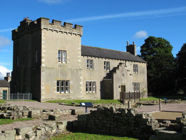
Birdoswald Farmhouse
- Overview Map Street View Birdoswald Farmhouse is situated within the ruins of the Banna Roman Fort on Hadrian's Wall. The farmhouse seen today, including the tower, was built in 1858, …
Co-Curate Page
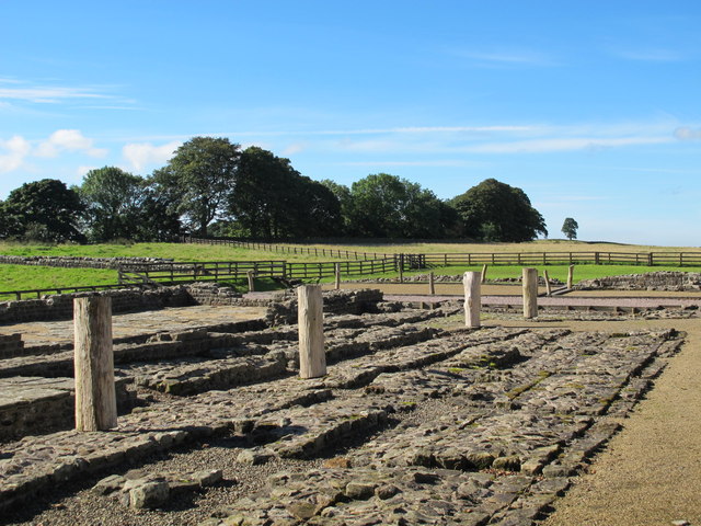
Birdoswald Roman Fort (Banna)
- Overview Map Street View Hadrian's Wall Glossary Birdoswald Roman Fort (known as Banna) is situated on the western part of Hadrian's Wall, about 1 mile west of Gilsland in Cumbria. …
Co-Curate Page
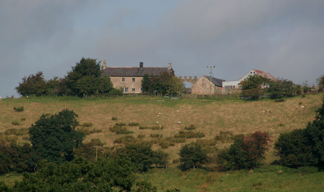
High House, near Gilsland
- Overview Map Street View HIgh House Farm is located about 2 miles West-South-West of Gilsland in Cumbria. The farmhouse and barn here date from 1677 and are Grade II listed …
Co-Curate Page
Triermain Castle (remains)
- Overview Map Street View The remains of a medieval enclosure castle are situated immediately to the east of Triermain Farm and stand on a small glacial mound. The castle was …

Co-Curate Page
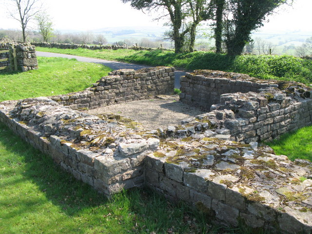
Pike Hill Signal Tower
- Overview Map Street View Hadrian's Wall Glossary The remains of Pike Hill Signal Tower are on Wall Mile 52 of Hadrian's Wall, located on the highest point of a ridge, …

Co-Curate Page
Wall Mile 52
- Overview Map Street View Interactive Glossary <Mile 51 | Mile 52 | Mile 53> Hadrian's Wall - Wall Mile 52 Hadrian's Wall stretches from the east to west coast of …

Co-Curate Page
Northrigg Hill
- Overview Map Northrigg Hill, is located about ½ mile north-east of the village of Banks in Cumbria. The farmhouse at Northrigg Hill is dated 1836 over it's entrance. The building …

Co-Curate Page
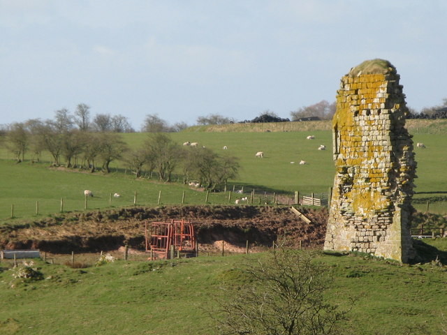
Lime kiln near Northrigg Hill
- Overview Map Street View There is an old lime kiln south of Northrigg Hill Farm. It is close to Pike Hill Signal Station and can be seen from the road …
Co-Curate Page
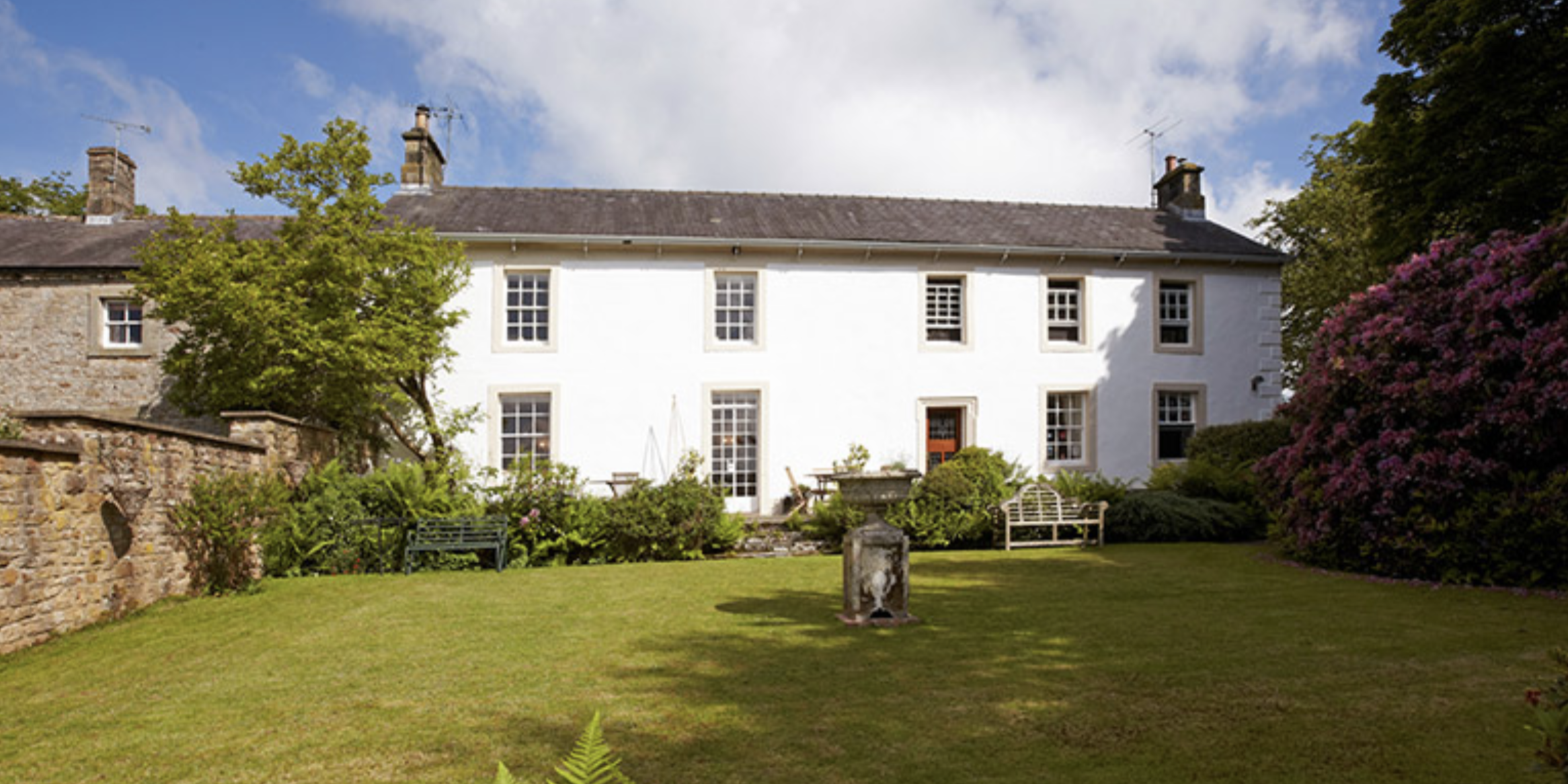
The Hill, Waterhead
- Overview Map Street View The Hill on the Wall is a house located close to Hadrian's Wall, just under a mile north-west of Gilsland. It dates from the mid-18th century, …

Co-Curate Page
Turret 52a (Banks East)
- Overview Map Street View Interactive Glossary About Turrets on Hadrian's Wall Turrets on Hadrian’s Wall were small watchtowers built into the wall, with two turrets per Roman mile, located between …
Co-Curate Page
Turret 51b (Leahill)
- Overview Map Street View Interactive Glossary Turrets on Hadrian’s Wall were small watchtowers built into the wall, with two turrets per Roman mile, located between larger milecastles. They provided elevated …

Co-Curate Page
Turret 49b (Birdoswald West)
- Overview Map Street View Interactive Glossary Turret 49B is a relatively well-preserved stone watchtower on Hadrian's Wall, located on Wall Mile 49, west of Birdoswald Fort. It is notable for …

Co-Curate Page
Wall Mile 50
- Overview Map Interactive Glossary <Mile 49 | Mile 50 | Mile 51> Hadrian's Wall - Wall Mile 50 Hadrian's Wall stretches from the east to west coast of England and …

Co-Curate Page
Wall Mile 51
- Overview Map Street View Interactive Glossary <Mile 50 | Mile 51 | Mile 52> Hadrian's Wall - Wall Mile 51 Hadrian's Wall stretches from the east to west coast of …

Co-Curate Page
Wall Mile 49
- Overview Map Street View Interactive Glossary <Mile 48 | Mile 49 | Mile 50> Hadrian's Wall - Wall Mile 49 Hadrian's Wall stretches from the east to west coast of …

Co-Curate Page
Birdoswald Farmhouse
- Overview Map Street View Birdoswald Farmhouse is situated within the ruins of the Banna Roman Fort on Hadrian's Wall. The farmhouse seen today, including the tower, was built in 1858, …
Co-Curate Page
Birdoswald Roman Fort (Banna)
- Overview Map Street View Hadrian's Wall Glossary Birdoswald Roman Fort (known as Banna) is situated on the western part of Hadrian's Wall, about 1 mile west of Gilsland in Cumbria. …
Co-Curate Page
High House, near Gilsland
- Overview Map Street View HIgh House Farm is located about 2 miles West-South-West of Gilsland in Cumbria. The farmhouse and barn here date from 1677 and are Grade II listed …
Co-Curate Page
Triermain Castle (remains)
- Overview Map Street View The remains of a medieval enclosure castle are situated immediately to the east of Triermain Farm and stand on a small glacial mound. The castle was …
Co-Curate Page
Pike Hill Signal Tower
- Overview Map Street View Hadrian's Wall Glossary The remains of Pike Hill Signal Tower are on Wall Mile 52 of Hadrian's Wall, located on the highest point of a ridge, …
Co-Curate Page
Wall Mile 52
- Overview Map Street View Interactive Glossary <Mile 51 | Mile 52 | Mile 53> Hadrian's Wall - Wall Mile 52 Hadrian's Wall stretches from the east to west coast of …
Co-Curate Page
Northrigg Hill
- Overview Map Northrigg Hill, is located about ½ mile north-east of the village of Banks in Cumbria. The farmhouse at Northrigg Hill is dated 1836 over it's entrance. The building …
Co-Curate Page
Lime kiln near Northrigg Hill
- Overview Map Street View There is an old lime kiln south of Northrigg Hill Farm. It is close to Pike Hill Signal Station and can be seen from the road …
Co-Curate Page
The Hill, Waterhead
- Overview Map Street View The Hill on the Wall is a house located close to Hadrian's Wall, just under a mile north-west of Gilsland. It dates from the mid-18th century, …
Co-Curate Page
Turret 52a (Banks East)
- Overview Map Street View Interactive Glossary About Turrets on Hadrian's Wall Turrets on Hadrian’s Wall were small watchtowers built into the wall, with two turrets per Roman mile, located between …
Co-Curate Page
Turret 51b (Leahill)
- Overview Map Street View Interactive Glossary Turrets on Hadrian’s Wall were small watchtowers built into the wall, with two turrets per Roman mile, located between larger milecastles. They provided elevated …
Co-Curate Page
Turret 49b (Birdoswald West)
- Overview Map Street View Interactive Glossary Turret 49B is a relatively well-preserved stone watchtower on Hadrian's Wall, located on Wall Mile 49, west of Birdoswald Fort. It is notable for …
Co-Curate Page
Wall Mile 50
- Overview Map Interactive Glossary <Mile 49 | Mile 50 | Mile 51> Hadrian's Wall - Wall Mile 50 Hadrian's Wall stretches from the east to west coast of England and …
Co-Curate Page
Wall Mile 51
- Overview Map Street View Interactive Glossary <Mile 50 | Mile 51 | Mile 52> Hadrian's Wall - Wall Mile 51 Hadrian's Wall stretches from the east to west coast of …


