Topics > Civil Parishes in Cumbria > Ulverston Town Council area > Historic Buildings and Monuments in Ulverston
Historic Buildings and Monuments in Ulverston
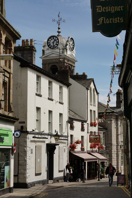
Listed buildings and scheduled monuments in Ulverston Civil Parish, Cumbria, from the National Heritage List for England[1]. Use the Search (below) if looking for a specific building / monument.
| Structure | List No. | Grade | Built~ | Note |
|---|---|---|---|---|
| Nos. 1 and 3, Queen Street | 1270179 | II | ||
| No. 1 Buxton Place | 1374969 | II | ||
| No. 1, King Street | 1375004 | II | ||
| No. 1, Market Place | 1270251 | II | ||
| Nos. 1,2 and 3, Gill Banks | 1375002 | II | ||
| No. 10, Market Place | 1270222 | II | ||
| Nos. 11 and 11a, Market Street | 1270230 | II | ||
| No. 11, King Street | 1375008 | II | ||
| No. 11, Queen Street | 1270185 | II | ||
| Nos. 12 and 14, Princes Street | 1270213 | II | ||
| Nos. 13 and 15, King Street | 1375009 | II | ||
| No. 13, Fountain Street | 1374994 | II | ||
| No. 13, Queen Street | 1270187 | II | ||
| No. 15, Queen Street | 1270188 | II | ||
| Nos. 15,17,19 and 19a, Fountain Street | 1374995 | II | ||
| Nos. 15-21, Daltongate | 1374988 | II | ||
| Nos. 16 and 16a, Queen Street | 1270189 | II | ||
| Nos. 16 and 18, Market Street | 1270231 | II | ||
| Nos. 17 and 19, Queen Street | 1270190 | II | ||
| No. 17, King Street | 1270238 | II | ||
| No. 18, Princes Street | 1270214 | II | ||
| No. 18, Queen Street | 1270191 | II | ||
| No. 19, King Street | 1270239 | II | ||
| Nos. 2 and 4, King Street | 1375005 | II | ||
| No. 2, Daltongate | 1374981 | II | ||
| No. 2, Market Street | 1270226 | II | ||
| No. 2, Union Street | 1270136 | II | ||
| Nos. 2-72, Sunderland Terrace | 1270173 | II | ||
| Nos. 20 and 22, Cavendish Street | 1374973 | II | ||
| Nos. 20 and 22, Queen Street | 1270192 | II | ||
| No. 20, King Street | 1270240 | II | ||
| No. 21, Fountain Street | 1374996 | II | ||
| No. 21, King Street | 1270241 | II | ||
| Nos. 22 and 24, Soutergate | 1270158 | II | ||
| No. 23, King Street | 1270243 | II | ||
| Nos. 24 and 26, Cavendish Street | 1374974 | II | ||
| Nos. 25 and 27, Fountain Street | 1374998 | II | ||
| No. 25, King Street | 1270244 | II | ||
| Nos. 26 and 26a, Soutergate | 1270159 | II | ||
| Nos. 26 and 30, Market Street | 1270232 | II | ||
| No. 26, Queen Street | 1270194 | II | ||
| Nos. 27 and 29, King Street | 1270245 | II | ||
| Nos. 28 and 30, Cavendish Street | 1374975 | II | ||
| No. 28, Queen Street | 1270195 | II | ||
| Nos. 29 and 31, Fountain Street | 1374999 | II | ||
| No. 3, Market Place | 1270217 | II | ||
| No. 3, Market Street | 1270227 | II | ||
| No. 30, Queen Street | 1270154 | II | ||
| No. 31, King Street | 1270246 | II | ||
| No. 32, Queen Street | 1270155 | II | ||
| Nos. 33 and 35, Soutergate | 1270163 | II | ||
| No. 34, Market Street | 1270233 | II | ||
| No. 34, Soutergate | 1270164 | II | ||
| Nos. 36 and 37, the Gill | 1270133 | II | ||
| No. 38, the Gill | 1270134 | II | ||
| Nos. 39, 41 and 43, Daltongate | 1374989 | II | ||
| No. 39, the Gill | 1270135 | II | ||
| Nos. 4 and 5, Market Place | 1270218 | II | ||
| Nos. 46 and 48, Market Street | 1270234 | II | ||
| No. 5, Market Street | 1270228 | II | ||
| No. 5, Queen Street | 1270181 | II | ||
| No. 50, Market Street | 1270235 | II | ||
| No. 51, Market Street | 1270236 | II | ||
| No. 52, Market Street | 1270237 | II | ||
| No. 54, Market Street | 1270196 | II | ||
| No. 56, Market Street | 1270197 | II | ||
| No. 58, Market Street | 1270198 | II | ||
| Nos. 6 and 7, Market Place | 1270219 | II | ||
| No. 6, Daltongate | 1374983 | II | ||
| Nos. 60 and 62, Market Street | 1270199 | II | ||
| Nos. 64 and 66, Market Street | 1270200 | II | ||
| No. 7, Fountain Street | 1374992 | II | ||
| No. 7, King Street | 1375006 | II | ||
| No. 7, Queen Street | 1270182 | II | ||
| No. 78, Soutergate | 1270166 | II | ||
| Nos. 8, 10 and 10a, Daltongate | 1374984 | II | ||
| No. 8, Market Place | 1270220 | II | ||
| No. 82, Soutergate | 1270167 | II | ||
| Nos. 9 and 11, Fountain Street | 1374993 | II | ||
| No. 9, King Street | 1375007 | II | ||
| No. 9, Market Street | 1270229 | II | ||
| No. 9, Queen Street | 1270183 | II | ||
| Barclays Bank | 1374979 | II | ||
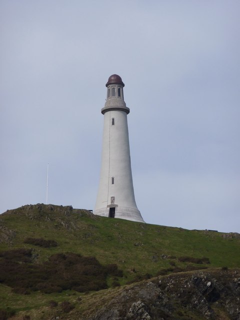
| Barrow Monument | 1375003 | II* | 1851 | On Hoad Hill |
| Braddylls Arms Public House | 1270223 | II | ||
| Bridge House | 1270138 | II | ||
| Canal Basin and Pier on Seaward End of Ulverston Canal,canal Foot | 1374971 | II | ||
| Church of Holy Trinity | 1270210 | II | ||
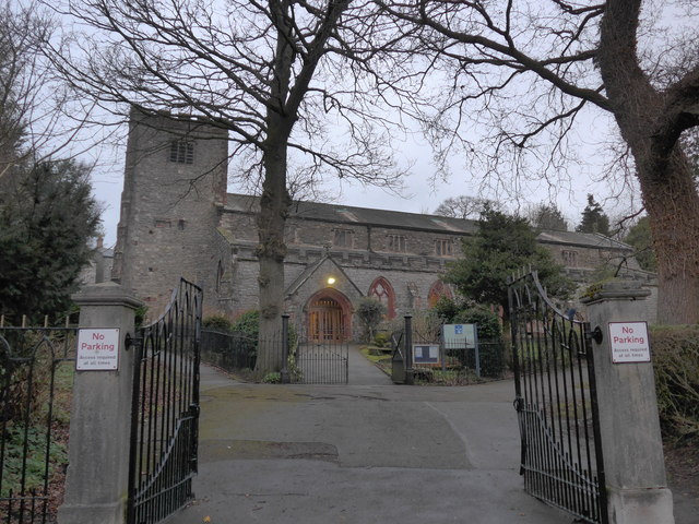
| Church of St Mary | 1374977 | II* | C12th | Largely rebuilt 1864-6 |
| Church Walk House and Attached Wall and Railings | 1374976 | II | ||
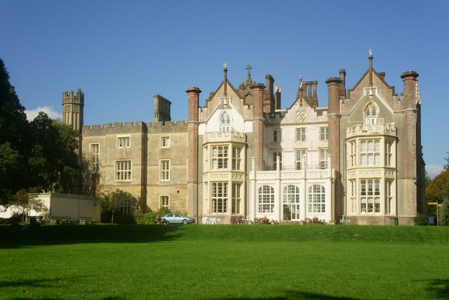
| Conishead Priory | 1270176 | II* | 1836 | Now with associated Buddhist temple |
| Dragley Beck Cottage | 1270157 | II | ||
| Dykelands | 1270248 | II | ||
| Ellers House | 1270204 | II | ||
| Fair View | 1374980 | II | ||
| Farmers Arms Public House | 1270252 | II | ||
| Ford House | 1374991 | II | ||
| Former Congregational Church Including Entrance Steps and Gates | 1270168 | II | ||
| Former drill hall including sergeant's house, administration and entrance blocks and boundary wallin | 1435378 | II | ||
| Former Goods Station Store and House | 1270216 | II | ||
| Former Midland Bank | 1270211 | II | ||
| Former Tollhouse in Garden of Number 45 | 1374990 | II | ||
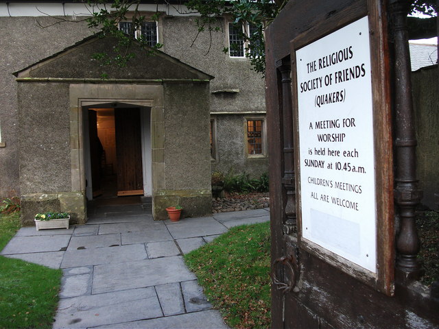
| Friends Meeting House | 1270207 | II* | 1688 | Swarthmoor. With C19th alterations |
| Garden Walls to North of Number 21 | 1374997 | II | ||
| Gothic Screen Wall in Garden to Rear of Numbers 11 and 13 | 1374987 | II | ||
| Hill Top | 1270249 | II | ||
| Hope and Anchor Public House | 1374982 | II | ||
| Ivy Cottage | 1270137 | II | ||
| Kings Head Public House | 1270186 | II | ||
| Lloyds Bank | 1270206 | II | ||
| Lock Cottage | 1374972 | II | ||
| Lonsdale House Hotel | 1374985 | II | ||
| National Westminster Bank | 1270180 | II | ||
| No. 20, Princes Street | 1270215 | II | ||
| No. 68, Market Street | 1270201 | II | ||
| Nos. 1 and 1A, Market Street | 1270225 | II | ||
| Nos. 9, 11, 13 and 14, Back Lane | 1374968 | II | ||
| Number 10 | 1270212 | II | ||
| Number 28 Including Wall and Railings | 1270160 | II | ||
| Number 30 and Attached Railings | 1270161 | II | ||
| Number 32 and Attached Railings | 1270162 | II | ||
| Numbers 9 and 9a | 1270221 | II | ||
| Old Daltongate House | 1374986 | II | ||
| Old Friends Inn Including Railings to Front Steps | 1270165 | II | ||
| Pound | 1375001 | II | ||
| Queens Hotel | 1270247 | II | ||
| Rolling Bridge over Ulverston Canal and Associated Accumulator Tower | 1404328 | II | 1883 | East Ulverson |
| Rose and Crown Public House | 1270242 | II | ||
| Sale Room | 1375000 | II | ||
| Sefton House | 1270156 | II | ||
| Springfield Mansions | 1270169 | II | ||
| Stockbridge House | 1270171 | II | ||
| Stone Cross Mansion | 1270172 | II | ||
| Sun Hotel | 1270205 | II | ||
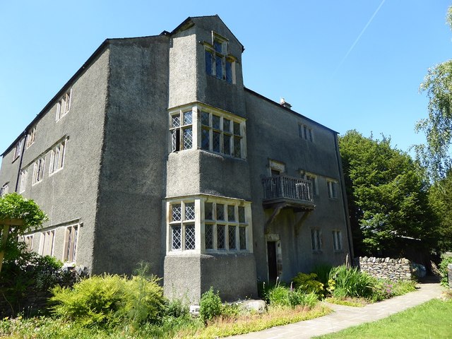
| Swarthmoor Hall | 1270174 | II* | 1568 | Swarthmoor |
| The Globe Inn | 1270184 | II | ||
| The Mill Public House | 1270208 | II | ||
| The Nook | 1374978 | II | ||
| The White House | 1270202 | II | ||
| Tower on Hermitage Hill at Sd 3301 4761 | 1270177 | II | ||
| Trinity House | 1270175 | II | ||
| Ulverston Heritage Centre (Rear Warehouse Only) | 1270250 | II | ||
| Ulverston Railway Station Including Nightclub Premises | 1270170 | II | ||
| Victoria Concert Hall (Now Premises of Emanuel Christian Centre and Shop) | 1270209 | II | ||
| Virginia House Hotel | 1270193 | II | ||
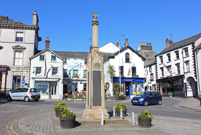
| War Memorial | 1270224 | II | 1921 | Market Square |
| Warehouse Attached to West of Number 1 | 1374970 | II | ||
| White House Cottage | 1270203 | II | ||
| Wilsons Monument, Ulverston Cemetery | 1270178 | II | ||
| Ulverston Conservation Area | - | n/a | Conservation Area |
Primary source: the National Heritage List for England - NHLE is the register of nationally protected historic buildings and sites in England, including listed buildings, scheduled monuments, protected wrecks, registered parks and gardens, and battlefields. The list is maintained by Historic England. Check NHLE for updates and new entries. Secondary sources: British Listed Buildings.
Co-Curate Page
Barrow Monument
- Overview About the Monument Timeline Map Street View View from top The Sir John Barrow Monument on Hoad Hill, Ulverston, was built from 1850 to 1851. The monument is Grade II* …
Co-Curate Page
Church of St Mary
- Overview About St Mary's Church Map Street View St Mary's is the Anglican Parish Church of Ulverston. The church tower dates from the mid-16th century and there is a 12th …
Co-Curate Page
Friends' Meeting House
- Overview Map Street View Swarthmoor Friends' Meeting House, is located on Meeting House Lane in the Croftlands area of Ulverston, about half a mile east of the village of Swarthmoor. The …
Co-Curate Page
Conishead Priory
- Overview About Conishead Priory Map Street View Conishead Priory is a large country house, located 1½ miles south east of Ulverston in Cumbria. It was built on the site of …
Co-Curate Page
Swarthmoor Hall
- Overview About Swarthmoor Hall Map Street View Swarthmoor Hall is a large house, built in c.1568, located in Ulverston, about half a mile east of the village of Swarthmoor. The …
Co-Curate Page
War Memorial, Ulverston
- Overview Map Street View The cenotaph in Ulverson is located at the head of the Market Square by the junction of Market Street and Queen's Street. The memorial commemorates 175 …

Co-Curate Page
Rolling Bridge over Ulverston Canal
- Overview Map This unusual rolling railway bridge carried the railway over Ulverston Canal, to the East of Ulveston. It was built for the Furness Railway Comany in 1883, designed by …

Co-Curate Page
Barrow Monument
- Overview About the Monument Timeline Map Street View View from top The Sir John Barrow Monument on Hoad Hill, Ulverston, was built from 1850 to 1851. The monument is Grade II* …
Co-Curate Page
Church of St Mary
- Overview About St Mary's Church Map Street View St Mary's is the Anglican Parish Church of Ulverston. The church tower dates from the mid-16th century and there is a 12th …
Co-Curate Page
Friends' Meeting House
- Overview Map Street View Swarthmoor Friends' Meeting House, is located on Meeting House Lane in the Croftlands area of Ulverston, about half a mile east of the village of Swarthmoor. The …
Co-Curate Page
Conishead Priory
- Overview About Conishead Priory Map Street View Conishead Priory is a large country house, located 1½ miles south east of Ulverston in Cumbria. It was built on the site of …
Co-Curate Page
Swarthmoor Hall
- Overview About Swarthmoor Hall Map Street View Swarthmoor Hall is a large house, built in c.1568, located in Ulverston, about half a mile east of the village of Swarthmoor. The …
Co-Curate Page
War Memorial, Ulverston
- Overview Map Street View The cenotaph in Ulverson is located at the head of the Market Square by the junction of Market Street and Queen's Street. The memorial commemorates 175 …