Topics > Civil Parishes in Cumbria > Shap Civil Parish > Historic Buildings and Monuments in Shap Civil Parish
Historic Buildings and Monuments in Shap Civil Parish
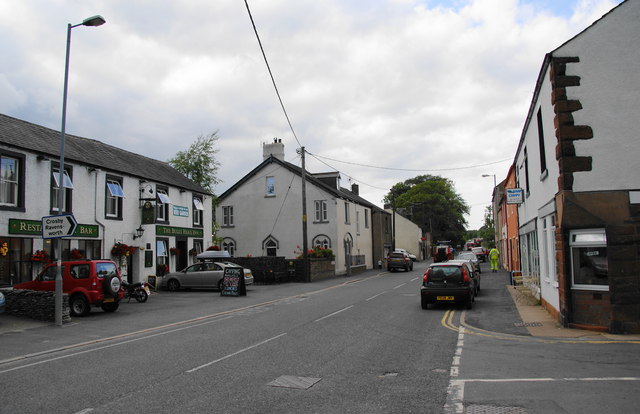
Listed buildings and scheduled monuments in Shap Civil Parish, Cumbria, from the National Heritage List for England[1]. Use the Search (below) if looking for a specific building / monument.
| Structure | List No. | Grade | Built~ | Note |
|---|---|---|---|---|
| Barn Adjoining North End of the Rockery | 1159231 | II | ||
| Barn to South of Thornship Farmhouse | 1145385 | II | ||
| Barn/Byre Range Adjoining Farmhouse Opposite Keld Farm | 1145379 | II | Keld | |
| Barn/Byre Range Adjoining to Right of Keld Farmhouse | 1311197 | II | Keld | |
| Barn/Byres to North East of Plane Trees | 1159119 | II | ||
| Byre to North East of Thornship Farmhouse | 1159254 | II | ||
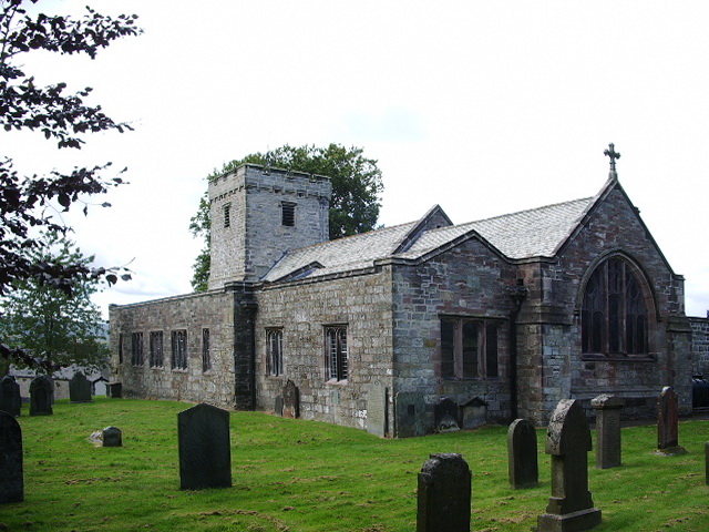
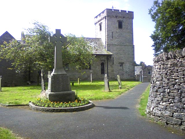
| Church of St Michael | 1159061 | II | C12th | Parts rebuilt C19th. |
| Coach House Adjoining New Ing Farmhouse | 1326749 | II | ||
| Cottage, Barn and Cart Shed Adjoining to Left of Keld Farmhouse | 1326748 | II | Keld | |
| Croft House | 1326751 | II | ||
| Cross Cottage | 1159161 | II | ||
| Farmhouse Opposite Keld Farm with Attached Hay Loft | 1159092 | II | Keld | |
| Forecourt Wall, Piers, Railings and Gate | 1159111 | II | ||
| Green Farmhouse with Adjoining Cottage, Barn/Byre Range and Area Wall | 1311133 | II | ||
| Green House with Pavilions | 1145383 | II | ||
| Greyhound Hotel with Milestone and Mounting Block | 1159149 | II | ||
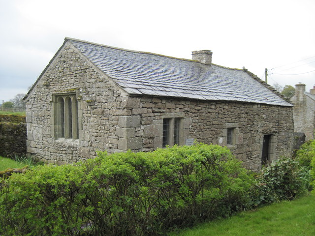
| Keld Chapel | 1067845 | II | C17th | Keld |
| Keld Farmhouse | 1145378 | II | Keld | |
| Lyndene | 1145381 | II | ||
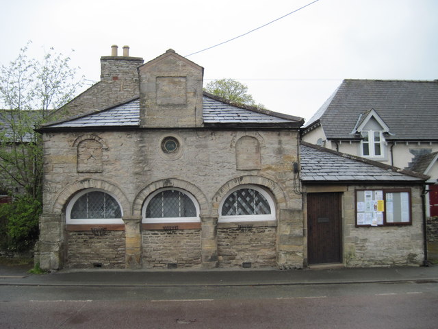
| Market Hall | 1145382 | II* | 1678 | aka Market Cross. |
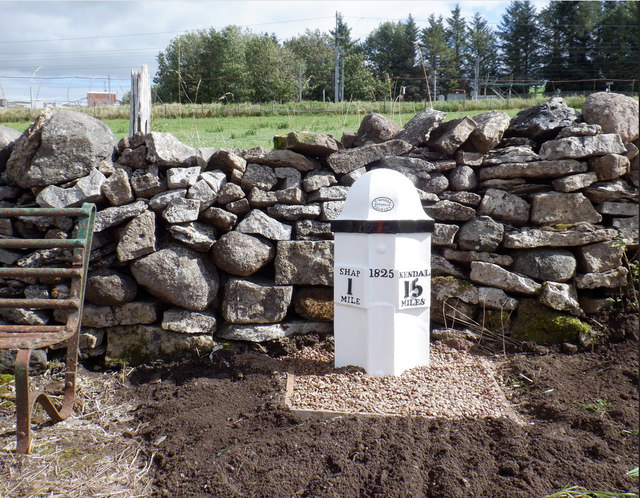
| Milepost (325 Yards North of Turn to Sleddale) | 1326747 | II | 1825 | A6, 1 mile south of Shap |
| Milepost (Opposite Shap Granite Works) | 1248964 | II | ||
| Milepost 350 Yards South of Turn to Sleagill | 1159044 | II | ||
| Milepost on Roadside to East of Croft House | 1159179 | II | ||
| New Ing Farmhouse | 1159105 | II | ||
| North Entrance Gates and Piers to St Michael's Churchyard | 1145377 | II | ||
| Plane Trees and Houses Adjoining East End | 1145380 | II | ||
| Shap War Memorial | 1457760 | II | 1920 | Churchyard of St Michael's |
| The Hermitage | 1326750 | II | ||
| The Rockery | 1326752 | II | ||
| Thornship Farmhouse and Byre Adjoining South End | 1145384 | II | ||
| Shap large regular stone circle | 1011639 | n/a | Scheduled Monument | |
| Shap Stone Alignment | 1011637 | n/a | Scheduled Monument | |
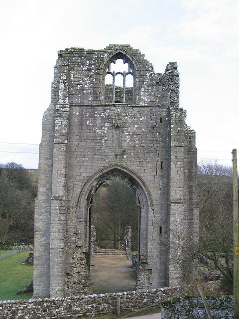
| Shap Premonstratensian Abbey, including the precinct wall, abbey mill and mill race, and two fishponds | 1011636 | n/a | C12th | Scheduled Monument. Shap Abbey, English Heritage |
| Keld Chapel | 1020669 | n/a | Scheduled Monument, Keld | |
| Skellaw Hill bowl barrow | 1007609 | n/a | Scheduled Monument |
Primary source: the National Heritage List for England - NHLE is the register of nationally protected historic buildings and sites in England, including listed buildings, scheduled monuments, protected wrecks, registered parks and gardens, and battlefields. The list is maintained by Historic England. Check NHLE for updates and new entries. Secondary sources: British Listed Buildings.
Co-Curate Page
Milepost near A6 turn to Sleddale
- This milepost, located 1 mile to the south of Shap is dated 1825. It was built for the Heron Syke Turnpike Trust which ran the toll road from Heron Syke …
Co-Curate Page
Shap Abbey (ruins)
- Overview About Shap Abbey Map Street View Shap Abbey is located about 1½ miles west of the village of Shap in Cumbria. The Abbey was founded in c.1200 by local …
Co-Curate Page
Keld Chapel
- Overview Map Street View Keld Chapel is located at the north east end of Keld, between Keld Lane and the access track to Thornship. The first documentary evidence of the …
Co-Curate Page
Shap War Memorial
- Overview Map Street View Shap War Memorial is located in the churchyard of St Michael’s Church in Shap. It was unvieled on the 5th of December 1920 by Lady Bagot …

Co-Curate Page
Milepost near A6 turn to Sleddale
- This milepost, located 1 mile to the south of Shap is dated 1825. It was built for the Heron Syke Turnpike Trust which ran the toll road from Heron Syke …
Co-Curate Page
Shap Abbey (ruins)
- Overview About Shap Abbey Map Street View Shap Abbey is located about 1½ miles west of the village of Shap in Cumbria. The Abbey was founded in c.1200 by local …
Co-Curate Page
Keld Chapel
- Overview Map Street View Keld Chapel is located at the north east end of Keld, between Keld Lane and the access track to Thornship. The first documentary evidence of the …