Topics > Civil Parishes in Cumbria > Sedbergh Civil Parish > Historic Buildings and Monuments in Sedbergh Civil Parish
Historic Buildings and Monuments in Sedbergh Civil Parish
Listed buildings and scheduled monuments in Sedbergh Civil Parish, Cumbria, from the National Heritage List for England[1]. In the absence of a published 'local list', some other public buildings of interest are also included. It has a searchable list, followed by Photos with links to more detailed information on specific buildings. Use the Search (below) if looking for a specific building / monument. Jump to Photos.
| Structure | List No. | Grade | Built~ | Note |
|---|---|---|---|---|
| Nos. 1, 2 and 3, Settlebeck | 1384211 | II | ||
| No. 1, Back Lane | 1384067 | II | ||
| No. 1, New Street (See details for further address information) | 1384189 | II | ||
| Nos. 15, 16 and 17, Back Lane | 1384068 | II | ||
| Nos. 18 and 19, Back Lane | 1384069 | II | ||
| No. 20, Back Lane | 1384070 | II | ||
| Nos. 3 and 5, New Street | 1384209 | II | ||
| No. 3, Main Street | 1384177 | II | ||
| No. 33, Loftus Hill | 1384168 | II | ||
| No. 33, Main Street | 1384179 | II | ||
| Nos. 34 and 35, Loftus Hill | 1384169 | II | ||
| No. 35, Main Street | 1384180 | II | ||
| Nos. 36 and 37, Loftus Hill | 1384170 | II | ||
| Nos. 37 and 39, Main Street | 1384181 | II | ||
| Nos. 4 and 5, Settlebeck | 1384212 | II | ||
| No. 4, Main Street | 1384178 | II | ||
| Nos. 48 and 50, Main Street | 1384183 | II | ||
| No. 57, Main Street | 1384186 | II | ||
| Nos. 6 and 7, Settlebeck | 1384213 | II | ||
| Nos. 7 and 9, New Street | 1384210 | II | ||
| Nos. 79 and 81, Main Street | 1384187 | II | ||
| Nos. 80, 82 and 84, Main Street | 1384188 | II | ||
| No. 95, Main Street | 1384190 | II | ||
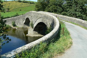
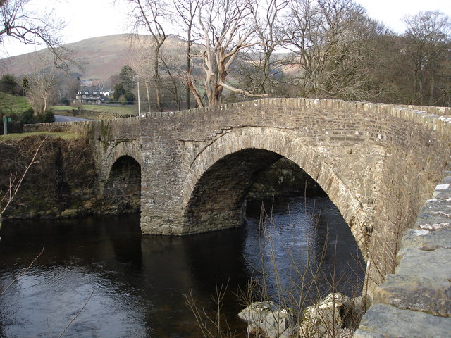
| Abbot Holme Bridge | 1384064 | II* | C17th | Abbot Holme |
| Abbot Holme House (East) and Attached Barn | 1384065 | II | C18th | Abbot Holme |
| Abbot Holme House (West) and Attached Stable to West and Barn to East | 1384066 | II | C18th | Abbot Holme |
| Archer's Hall | 1384200 | II* | 1681 | Milthrop |
| Bank Barn Approximately 100 Metres to North West of Catholes Farmhouse | 1384088 | II | ||
| Bank Barn Approximately 50 Metres East of High Branthwaite Farmhouse | 1384151 | II | ||
| Bank Barn Attached to East End of Draw Well Farmhouse | 1384147 | II | ||
| Banty Gill Bridge | 1384139 | II | ||
| Barn Adjoining Hollin Hill Farmhouse to East | 1384083 | II | ||
| Barn and Cottage Attached to West End of High Birks Farmhouse | 1384076 | II | ||
| Barn Approximately 10 Metres West of Taythes | 1384117 | II | ||
| Barn Approximately 15 Metres South East of Castlehaw Farmhouse | 1384086 | II | ||
| Barn Approximately 20 Metres to North West of Archer's Hall | 1384201 | II | ||
| Barn Approximately 25 Metres North of Cross Keys Hotel | 1384098 | II | ||
| Barn Approximately 25 Metres South East of Garths Farmhouse | 1384062 | II | ||
| Barn Approximately 30 Metres South of Fell Yeat Farmhouse at Side | 1384125 | II | ||
| Barn Approximately 30 Metres to North of Mire House | 1384112 | II | ||
| Barn Approximately 5 Metres North of Cautley Thwaite Farmhouse | 1384093 | II | C18th | Cautley Thwaite |
| Barn Approximately 5 Metres South of Low Haygarth Farmhouse | 1384104 | II | C18th | Low Haygarth |
| Barn Attached to West End of Uldale House | 1384120 | II | ||
| Barn Attached to West Side of Low Hollins Farmhouse | 1384128 | II | ||
| Beck Farmhouse and Attached Barn | 1384140 | II | ||
| Beckside Farmhouse and Attached Barn to South West | 1384141 | II | ||
| Birks Cottage | 1384074 | II | ||
| Birks Farmhouse and Attached Barn | 1384090 | II | ||
| Blands Gill Farmhouse with Attached Barn to North | 1384142 | II | ||
| Bluecaster | 1384091 | II | ||
| Boer Wall Memorial Approximately 40 Metres North of Chapel of Sedbergh School | 1384172 | II | ||
| Boundary Wall and Railings to Chapel at Sedbergh School with Gateways and Lamp | 1384173 | II | ||
| Browside Cottage | 1384203 | II | ||
| Castlehaw Farmhouse | 1384085 | II | ||
| Catholes Farmhouse | 1384087 | II | ||
| Cautley Thwaite Farmhouse | 1384092 | II | C19th | Cautley |
| Chapel at Sedbergh School | 1384171 | II* | 1897 | Sedbergh, Loftus Hill. |
| Church of St Andrew | 1384191 | I | C16th | On the site of earlier church |
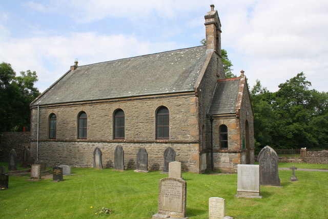
| Church of St Gregory (Vale of Lune Chapel) | 1384060 | II | 1850 | |
| Church of St Mark | 1384094 | II | 1847 | Cautley |
| Church of the Holy Trinity | 1384143 | II | 1838 | Howgill |
| Classroom Block to East of Powell Hall at Sedbergh School | 1384217 | II | ||
| Crook of Lune Bridge | 1384145 | II* | C16th | Partly in this parish |
| Cross Hall Cottage | 1384095 | II | ||
| Cross Haw Farmhouse with Attached Outbuildings | 1384096 | II | ||
| Cross Keys Hotel | 1384097 | II | C17th | Cautley. Temperance Inn |
| Danny Bridge | 1384131 | II | ||
| Draw Well Farmhouse | 1384146 | II | ||
| Evans House and Attached Area Railings to the Front | 1384193 | II | ||
| Fell Yeat Farmhouse at Side | 1384124 | II | ||
| Folly Yard | 1384195 | II | ||
| Folly Yard | 1384196 | II | ||
| Former Barn Approximately 20 Metres to North West of Catholes Farmhouse | 1384089 | II | ||
| Former Mitchell's Pharmacy | 1384184 | II | ||
| Former Smithy at Farfield Mills | 1384137 | II | C19th | Farfield Mills |
| Garden Wall with Two Bee-Boles Approximately 10 Metres South of Draw Well Farmhouse | 1384148 | II | ||
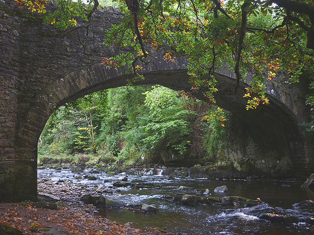
| Garsdale Bridge to North West of Farfield Mills | 1384073 | II | C17th | Over Clough River |
| Garths Farmhouse | 1384061 | II | ||
| Gate Farmhouse | 1384149 | II | ||
| Gateside House | 1384121 | II | ||
| Green Farmhouse | 1384126 | II | ||
| Group of Farm Buildings 100 Metres West of Ingmire Hall | 1384162 | II | ||
| Hallbank | 1384129 | II | ||
| Hebblethwaite Cottage and Attached Barn to West | 1382850 | II | ||
| Hebblethwaite Hall | 1384099 | II | C16th | Hebblethwaite Hall Drive |
| High Beckside Farmhouse and Attached Former Barn | 1384100 | II | ||
| High Birks Farmhouse | 1384075 | II | ||
| High Branthwaite Farmhouse | 1384150 | II | ||
| High Fawes | 1384130 | II | ||
| High Oaks | 1384164 | II* | 1706 | The Oaks (house) |
| High Wardses Bridge | 1384101 | II | ||
| Hill | 1382830 | II | ||
| Hollin Hill Farmhouse | 1384082 | II* | 1712 | Soolbank, Buckbank Lane. |
| Howgill War Memorial | 1457238 | II | 1920 | Howgill |
| Ingmire Gardens and Associated Walled Garden | 1384160 | II | ||
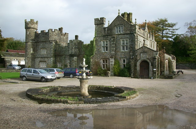
| Ingmire Hall and Stables and Outbuildings to North Known As Ingmire Cottage | 1384161 | II | C16th | Mansion with pele tower |
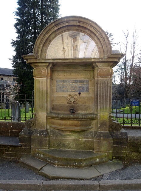
| Jubilee Drinking Fountain, Sedbergh | 1384123 | II | 1897 | Sedburgh, Finkle Street |
| K6 Telephone Kiosk Approximately 20 Metres South East of Holy Trinity Churchyard | 1384144 | II | ||
| K6 Telephone Kiosk Beside Churchyard | 1384192 | II | ||
| Killington New Bridge | 1137973 | II | C19th | B6256, near High Oaks |
| Kilnbeck Farmhouse and Attached Barn | 1384122 | II | ||
| Lincolns Inn Bridge over the River Lune | 1384063 | II | ||
| Low Beckside Farmhouse and Attached Peat House and Barn | 1384102 | II | ||
| Low Birks | 1384077 | II | ||
| Low Branthwaites | 1384132 | II | ||
| Low Brigflatts | 1384078 | II | ||
| Low Haygarth Farmhouse | 1384103 | II | 1728 | Off Cautley Road |
| Low Hollins Farmhouse and Attached Garden Wall | 1384127 | II | ||
| Low Ridding and Former Barn Attached to West End | 1384105 | II | ||
| Lune Viaduct at Newbys Dub | 1086911 | II* | 1861 | Waterside |
| Mackereth Hill and Attached Barn | 1384106 | II | C17th | Cautley Road |
| Marshall House and Attached Area Railings | 1384185 | II | ||
| Middleton Bridge over River Rawthey | 1384163 | II | ||
| Milestone (Sedbergh 1) Approximately 180 Metres West of Archer's Hall | 1384204 | II | ||
| Milestone (Sedbergh 2) to South East of Low Ridding | 1384107 | II | C19th | A683, Cautley Road, Low Ridding |
| Milestone (Sedbergh 3) to East of Steps End | 1384108 | II | C19th | A683, Cautley Road |
| Milestone (Sedbergh 4) by High Wardses | 1384109 | II | C19th | A683, Cautley Road |
| Milestone (Sedbergh 5) at NGR 7045 9731 on A683 | 1384110 | II | C19th | A683, Cautley Road |
| Milestone Approximately 100 Metres East of Low Branthwaites on Hawes Road | 1384133 | II | C19th | A684, Hawes Road |
| Milestone Approximately 120 Metres East of Junction with Frostrow Lane | 1384134 | II | C19th | A684, Hawes Road |
| Milestone at South East Corner of Sunny Bank | 1384215 | II | ||
| Milestone on East Corner of Junction with Frostrow Lane | 1384135 | II | ||
| Milestone on East Side of Lane Approximately 30 Metres South of Fairmile Beck | 1384152 | II | ||
| Milestone on South of Road Approximately 100 Metres East of Killington New Bridge | 1384165 | II | C18th | A6256 |
| Mill Cottage | 1384154 | II | ||
| Mill House | 1384155 | II | ||
| Millers Cottage | 1384156 | II | ||
| Millthrop Bridge over River Rawthey | 1384206 | II | C17th | Millthrop |
| Mire House | 1384111 | II* | C17th | Cautley |
| Moss Farm and Moss Cottage | 1384136 | II | ||
| Nether Bainbridge Farmhouse | 1384157 | II | ||
| New Bridge | 1384138 | II | 18th | Sedbergh / Soolbank |
| No. 41 Main Street | 1384182 | II | ||
| Palmers Hill | 1384199 | II | ||
| Pedge Croft Farmhouse | 1384175 | II | ||
| Powell Hall at Sedbergh School | 1384216 | II | ||
| Queen Victoria Memorial Cross, Queen's Garden | 1400656 | II | ||
| Railton Yard | 1382853 | II | ||
| Rawthey Bridge (road) | 1384113 | II | 1822 | Cautley Road |
| Rawthey Bridge (rail) | 1384079 | II | 1861 | Brigflatts |
| Rue Crofts and Attached Barn to North | 1384214 | II | ||
| School House at Sedbergh School | 1384174 | II | ||
| Sedbergh War Memorial | 1400659 | II | 1920 | Churchyard, St Andrews. |
| Small Barn Approximately 30 Metres North of Archer's Hall | 1384202 | II | ||
| Spedding House and Attached Barn to South | 1384207 | II | ||
| Stable and School Room to North West of the Friends Meeting House | 1384081 | II | ||
| Stone Hall | 1384219 | II* | 1695 | Soolbank, Stonehall Lane |
| Straight Bridge | 1384114 | II | ||
| Taythes Bridge over Taythes Gill | 1384115 | II | ||
| Taythes Farmhouse | 1384116 | II | ||
| The Friends Meeting House and Adjoining Cottage to West | 1384080 | I | 1675 | Brigflatts |
| The Hill | 1384166 | II* | 1712 | Marthwaite, Kirkby Lonsdale Road |
| The Old Grammar School (Now the School Library) | 1384071 | II* | 1716 | Sedbergh, Back Lane. |
| The Old Vicarage | 1384072 | II | ||
| Thorns Cottage | 1384220 | II | ||
| Thorns Hall and Attached Stable Wing to Rear | 1384176 | II* | C17th | Sedbergh, Long Lane |
| Thursgill | 1384084 | II | C17th | Buckbank Lane |
| Thwaite Farmhouse | 1384158 | II | ||
| Uldale House | 1384119 | II | ||
| Walled Garden Approximately 40 Metres South of Evans House | 1384194 | II | ||
| War Memorial Cloister at Sedbergh School | 1384218 | II* | 1924 | Sedbergh, Station Road |
| Weavers Yard | 1384197 | II | ||
| Weavers Yard | 1384198 | II | ||
| Wesleyan Methodist Church | 1384118 | II | 1845 | Cautley |
| Winder Cottage (Number 9) | 1384159 | II | ||
| Castlehaw Tower, motte and bailey castle and Royal Observer Corps monitoring post | 1007128 | n/a | ||
| Queen's Garden | 1400679 | II | Listed Park and Garden | |
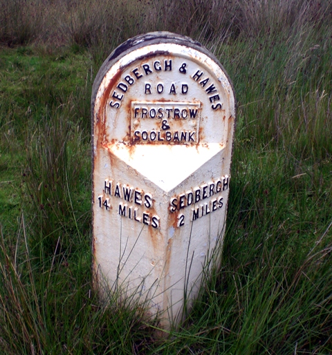
| Old Milestone 2 | not listed | n/a | ? | Cautley Road, Narthwaite |
| Frostrow Methodist Chapel | not listed | n/a | 1886 | Hawes Road |
| Farfield Mill | not listed | n/a | c.1837 | Garsdale Road. Now Arts & Heritage centre |
| Farfield Mill Conservation Area | - | n/a | Conservation Area | |
| Sedburgh Conservation Area | - | n/a | Conservation Area |
Primary source: the National Heritage List for England - NHLE is the register of nationally protected historic buildings and sites in England, including listed buildings, scheduled monuments, protected wrecks, registered parks and gardens, and battlefields. The list is maintained by Historic England. Check NHLE for updates and new entries. Secondary sources: British Listed Buildings.
Co-Curate Page
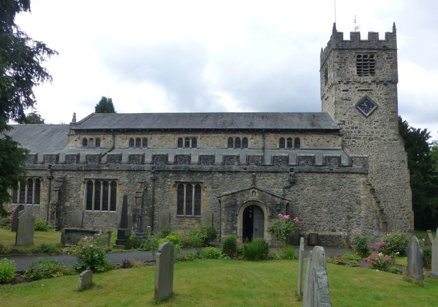
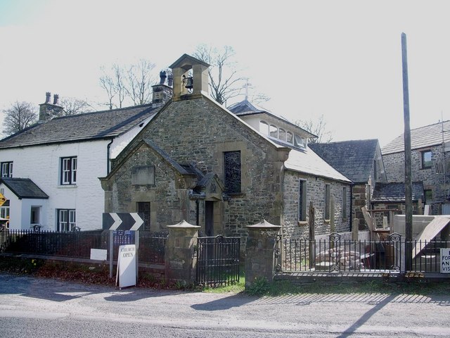
Church of St Andrew, Sedbergh
- Overview About St Andrew's Church Map Street View St Andrew's Church is in Main Street, Sedbergh, Cumbria, England. It is an active Anglican parish church in the deanery of …
Co-Curate Page
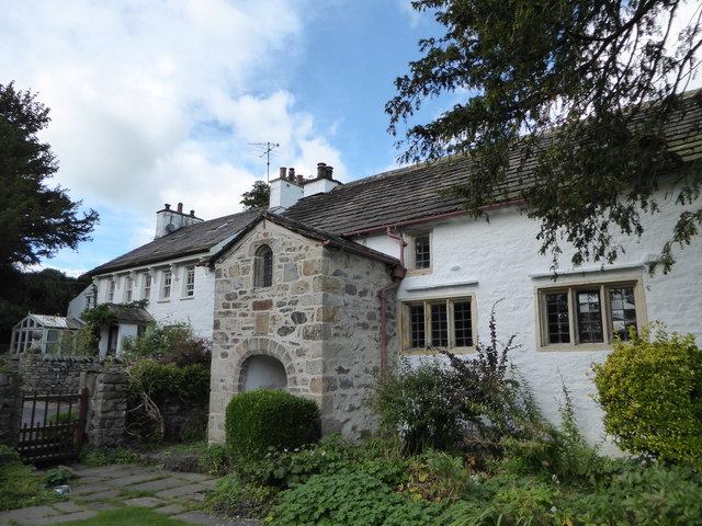
Brigflatts Quaker Meeting House, Sedbergh
- Overview About Brigflatts Map Brigflatts Quaker Meeting House, located about half a mile south-west of Sedbergh in Cumbria, was built in 1675.[1] George Fox, the founder of the Religious Society …
Co-Curate Page
Crook of Lune Bridge
- Overview Map Street View This stone road bridge over the River Lune, near Lowgill in Cumbria, was built in the 16th century or possibly earlier. The bridge formed part of …
Co-Curate Page
Church of St Gregory (Vale of Lune Chapel)
- Overview Map Street View The former Church of St Gregory (aka Vale of Lune Chapel) is located by the A684 road, about 1 mile west of Sedbergh. It was built …
Co-Curate Page
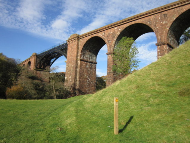
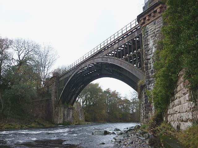
Lune Viaduct at Newbys Dub
- Overview Map Street View The Lune Viaduct at Newbys Dub is located near the hamlet of Waterside and about 1½ miles north-west of Sedbergh. It was built to carry the …
Co-Curate Page
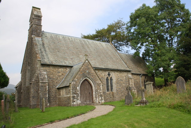
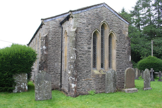
Church of St Mark, Cautley
- Overview Map St Mark's Church, in Cautley, was built in 1847, designed in a Gothic-style, by the eminent victorian architect, William Butterfield. The church is Grade II listed on the …
Co-Curate Page
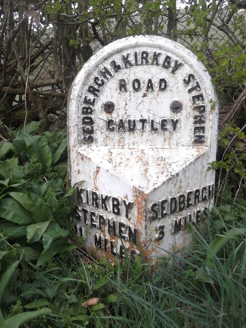
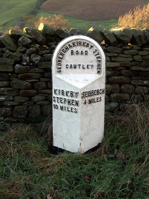
Milestone (Sedbergh 3), Cautley
- This old milestone is located by Cautley Road (the A683), in Cautley, north of Cautley Mentodist Chapel. It is a wrought iron casting, and was erected by the County Council …
Co-Curate Page
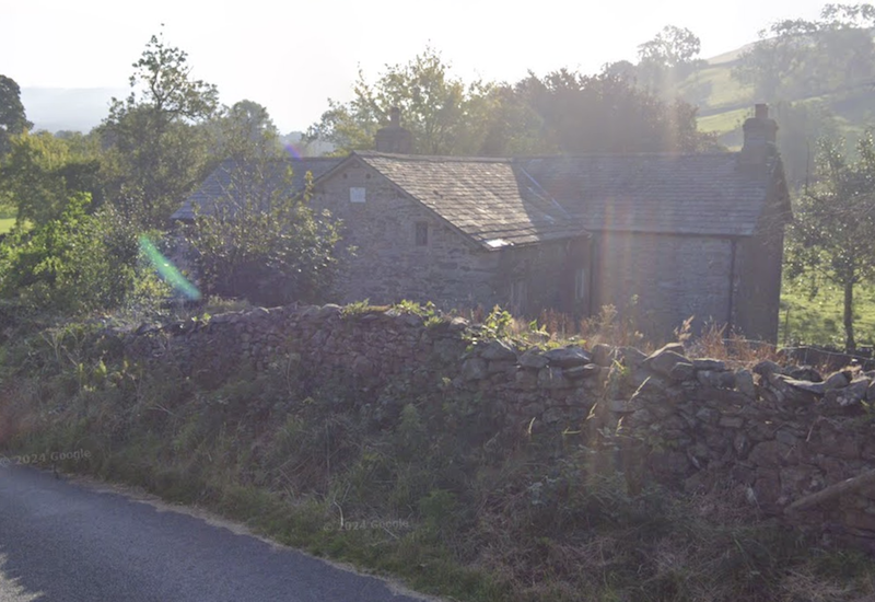
Thursgill, Cumbria
- Overview Map Street View Thursgill is a hamlet / farm on Buckbank Lane, located about 1½ miles north-east of Sedbergh. The house here, a former farmhouse, dates from the late …
Co-Curate Page
Church of the Holy Trinity, Howgill
- Overview Map Street View Inside Holy Trinity Church is located on Howgill Lane, close to Chapel Beck, in Howgill. It was built in 1838, by Edmund Sharpe. It replaced an …
Co-Curate Page
War Memorial, Howgill
- This war memorial is located in the churcyard of Holy Trinity Church, off Howgill Lane in Howgill, Sedbergh. The memorial was unveiled in October 1920 to commemorate seven local servicemen who …
Co-Curate Page
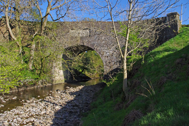
Abbot Holme Bridge
- Overview Map Street View Abbot Holme Bridge carries the road over the River Dee at Abbot Holme, to the south of Sedbergh. The stone bridge dates from the 17th century …
Co-Curate Page
House at East of Abbot Holme
- Overview Map Street View The farmhouse at the East side of Abbot Holme, has an attached cart-shed and barn are thought to date from the mid-18th century, with later alterations. …
Co-Curate Page
House at West of Abbot Holme
- Overview Map Street View The farmhouse at the West side of Abbot Holme, has an attached stable and a cart-shed or barn, and thought to date from the late-17th or …

Co-Curate Page
Old Grammar School (now the School Library)
- Overview Map Street View The Old Grammar School is located by the junction of Back Lane and Loftus Hill, in Sedburgh. The building is dated 1716 on the original doorway, …
Co-Curate Page
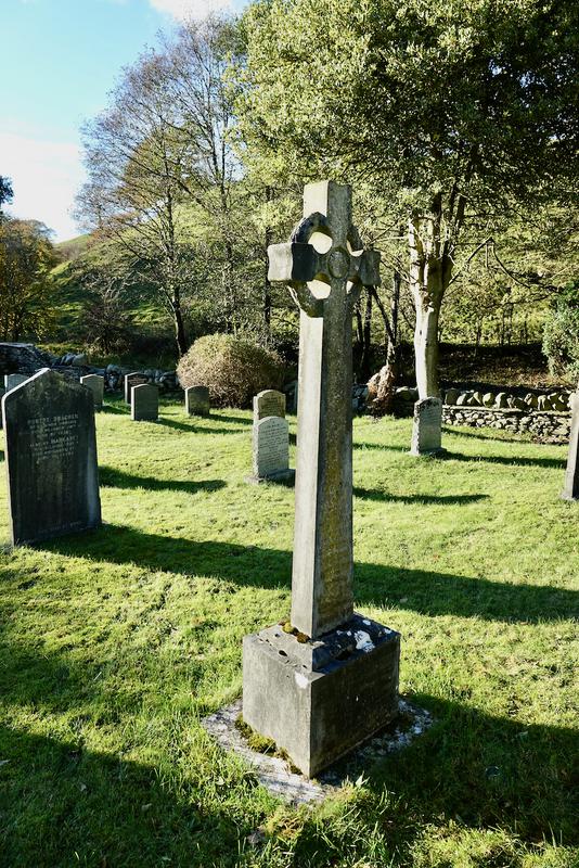
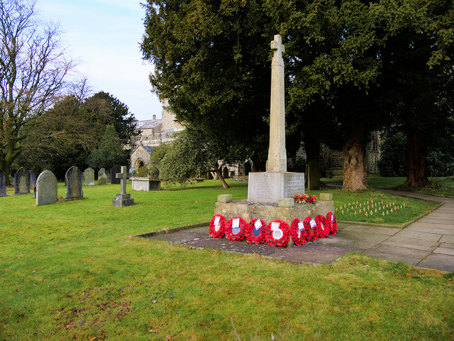
Sedbergh War Memorial
- Overview Map Street View Sedbergh War Memorial is located in the churchyard of St Andrew's Church, off Finkle Street, in Sedbergh. The memorial was designed by Sir John Hubert Worthington …
Co-Curate Page
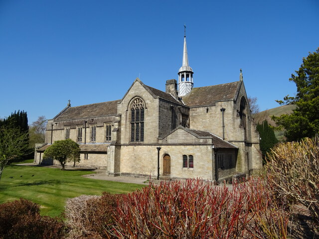
Sedbergh School Chapel
- Overview Map Street View The Chapel of Sedbergh School is located by the junction of Loftus Hill and Busk Lane, in Sedbergh. It was built in 1895-1897, replacing an earlier …
Co-Curate Page
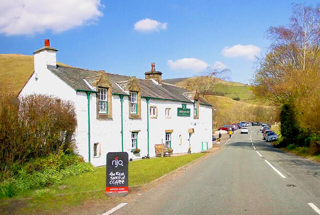
The Cross Keys Temperance Inn
- Overview Map Street View The Cross Keys Temperance Inn is located in Cautley, on Cautley Road (A683), about 4 miles north-east of Sedbergh and 9 miles south-west of Kirkby Stephen. …
Co-Curate Page
Low Haygarth
- Overview Map Street View Low Haygarth is a farm located off Cautley Road, in Cautley, about 4 miles north-east of Sedbergh in Cumbria. It is situated at the foot of …
Co-Curate Page
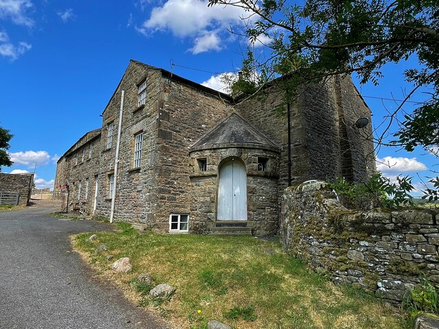
Hebblethwaite Hall (the Hall)
- Overview Map Street View The Hall at Hebblethwaite Hall Farm is located in Cautley, near Sedbergh. It has a 16th or early 17th century core. The L-plan house was altered …
Co-Curate Page
Mackereth Hill
- Overview Map Street View Mackereth Hill is a former farmhouse in Cautley, located on Cautley Road, by the junction with Hebblethwaite Hall Drive, and close to Low Ridding. It dates …
Co-Curate Page
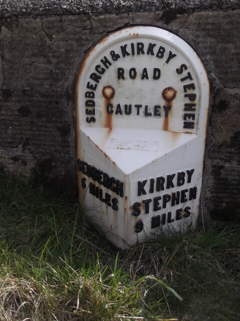
Milestone (Sedbergh 2), Low Ridding
- Overview Map Street View This old milestone is located on Cautley Road (A683), between Low Ridding and Mackereth Hill, in Cautley, 2 miles north-east of Sedbergh. It is a wrought …
Co-Curate Page
Milestone (Sedbergh 4), High Wardses
- Overview Map Street View This old milestone is located on Cautley Road (A683), near High Wardses, in Cautley, 4 miles north-east of Sedbergh. It is a wrought iron casting, and …
Co-Curate Page
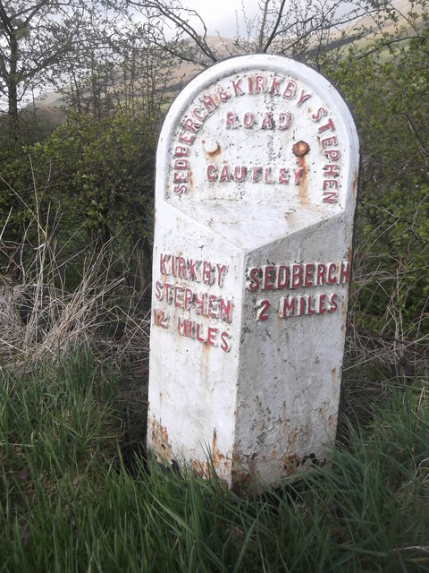
Milestone (Sedbergh 5), Narthwaite
- Overview Map Street View This old milestone is located on Cautley Road (A683), about ½ mile north of the Cross Keys Temerance Inn in Cautley, and south-east of Narthwaite. The milestone …
Co-Curate Page
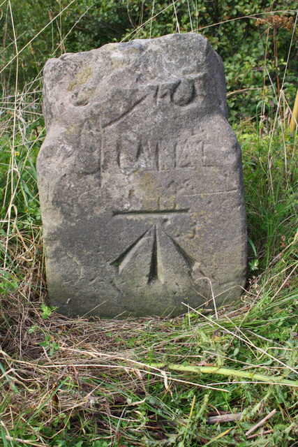
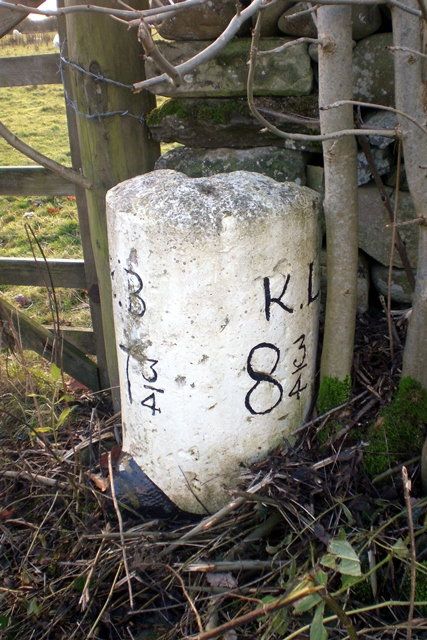
Old Milestone #2, Narthwaite
- This old milestone, by Cautley Road (A683), just east of Narthwaite, is a short distance south of the milestone for 5 miles to Sedbergh. "This stone is a favourite with …
Co-Curate Page
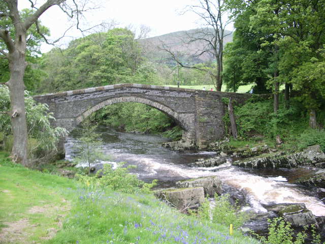
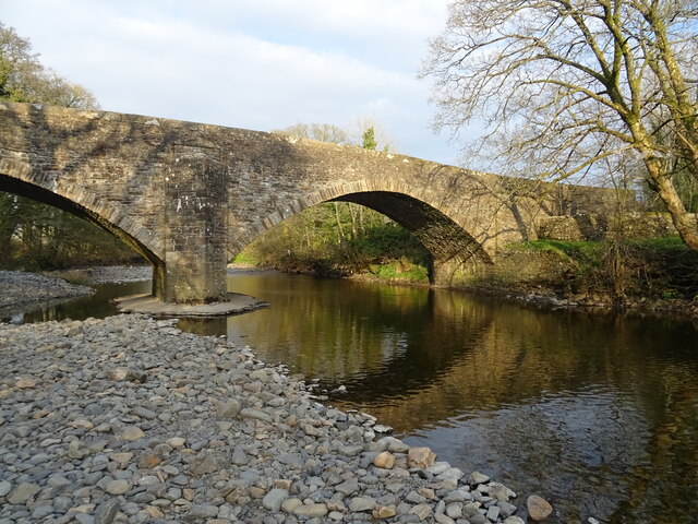
Millthrop Bridge
- Overview History Map Street View Millthrop Bridge is a stone road bridge over the River Rawthey, to the north of Millthrop and south of Sedbergh. The bridge dates from the …
Co-Curate Page
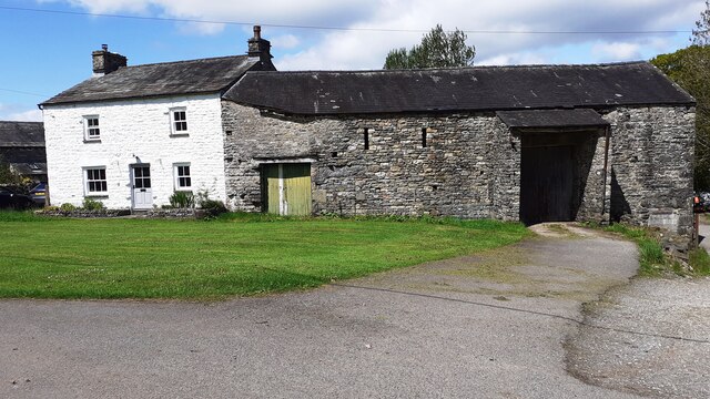
Archers Hall, Millthrop
- Overview Map Street View Archers Hall, located at the west of Millthrop, is a farmhouse, dated 1681 on the gable of it's rear wing. It is a Grade II* listed …
Co-Curate Page
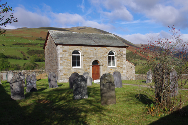
Frostrow Methodist Chapel
- Overview Map Street View The former Frostrow Methodist Chapel is located on Hawes Road (A684), about 1½ mile south-east of the town of Sedbergh. Frostrow Wesleyan Methodist Chapel was built …
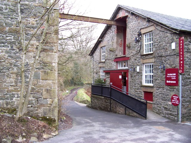
Co-Curate Page
Farfield Mill, Sedbergh
- Overview Map Street View Farfield Mill, by the Clough River, is a former woollen mill, which operated from 1837 to 1992. It is located on a minor road off the …

Co-Curate Page
Former Smithy at Farfield Mills
- Overview Map This cottage at Farfield Mills is a former Blacksmith and Joiner's Shop with an adjacent store room. It dates from the early 19th century and is a Grade …
Co-Curate Page
Garsdale Bridge by Farfield Mill
- Overview Map Garsdale Bridge is located a short distance north-west of Farfield Mill, about a mile east of the town of Sedbergh. It carries a minor road over Clough River. …

Co-Curate Page
Milestone (Sedbergh 1), A684 Hawes Road
- Overview Map Street View This old milestone is located on Hawes Road (A684) east of the junction with Frostrow Lane, 1 mile east of Sedbergh. It is a wrought iron …
Co-Curate Page
Milestone (Sedbergh 2), A684 Hawes Road
- Overview Map Street View This old milestone is located on Hawes Road (A684) south of Garsdale Rigg and north of Low Branthwaites, 2 miles east of Sedbergh. It is a …
Co-Curate Page
Jubilee Drinking Fountain, Sedbergh
- Overview Map Street View The Jubilee Drinking Fountain is located on Finkle Street in Sedbergh, built into the churchyard wall of St Andrew's Church, with stone benches either side of …
Co-Curate Page
New Bridge, Sedbergh
- Overview Map Street View New Bridge (aka Soolbank Bridge) is a bridge at the east of Sedbergh town, which carries Hawes Road (A684) over the River Rawthey. The bridge, with …
Co-Curate Page
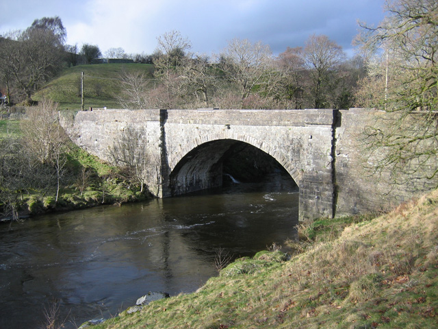
Rawthey Bridge (road)
- Overview Map Street View Rawthey Bridge is a bridge which carries Caitley Road (A683) over the River Rawthey in Cautley, north of the town of Sedburgh. The bridge was rebuilt …
Co-Curate Page
Rawthey Bridge (rail), Brigflatts
- Overview Map Rawthey Bridge carried the railway over River Rawthey, near Brigflatts, about 4 miles northof Sedbergh, in Cumbria. It was built 1857-1861, for the Lancaster and Carlisle Railway Company. …
Co-Curate Page
Killington New Bridge, B6256
- Overview Map Street View Killington New Bridge carries the road (B6256) over the River Lune in Cumbria, it is located about 2½ miles south-west of the town of Sedbergh. The …
Co-Curate Page
The Oaks (house), High Oaks, Sedbergh
- Overview Map Street View The Oaks is a large house in the hamlet of High Oaks, near Sedbergh, The 3 storey house is dated 1706 on its porch, but perhaps …
Co-Curate Page
Old Milestone near Killington New Bridge
- Overview Map Street View This old milestone, by the B6256 road, is located about 100 metres east of Killington New Bridge. It indicates 7¾ miles to B.B. (Borrow Bridge) and …
Co-Curate Page
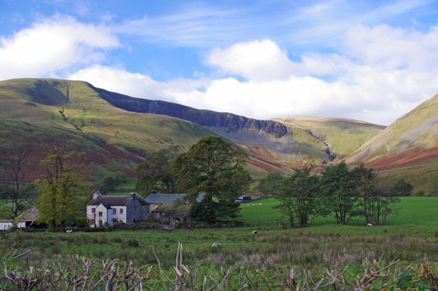
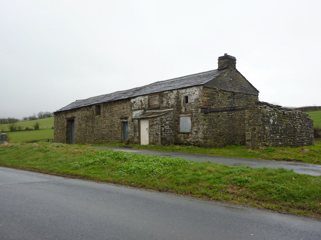
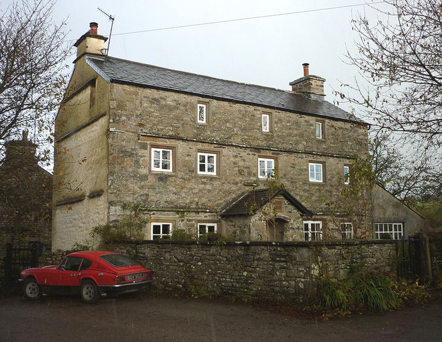
Cautley Thwaite
- Overview Map Street View Cautley Thwaite is a farm in Caurtley, about 3½ miles norh-east of the town of Sedbergh. The farm is situated by the River Rawthey and at …

Co-Curate Page
Church of St Andrew, Sedbergh
- Overview About St Andrew's Church Map Street View St Andrew's Church is in Main Street, Sedbergh, Cumbria, England. It is an active Anglican parish church in the deanery of …
Co-Curate Page
Brigflatts Quaker Meeting House, Sedbergh
- Overview About Brigflatts Map Brigflatts Quaker Meeting House, located about half a mile south-west of Sedbergh in Cumbria, was built in 1675.[1] George Fox, the founder of the Religious Society …
Co-Curate Page
Crook of Lune Bridge
- Overview Map Street View This stone road bridge over the River Lune, near Lowgill in Cumbria, was built in the 16th century or possibly earlier. The bridge formed part of …
Co-Curate Page
Church of St Gregory (Vale of Lune Chapel)
- Overview Map Street View The former Church of St Gregory (aka Vale of Lune Chapel) is located by the A684 road, about 1 mile west of Sedbergh. It was built …
Co-Curate Page
Lune Viaduct at Newbys Dub
- Overview Map Street View The Lune Viaduct at Newbys Dub is located near the hamlet of Waterside and about 1½ miles north-west of Sedbergh. It was built to carry the …
Co-Curate Page
Church of St Mark, Cautley
- Overview Map St Mark's Church, in Cautley, was built in 1847, designed in a Gothic-style, by the eminent victorian architect, William Butterfield. The church is Grade II listed on the …
Co-Curate Page
Milestone (Sedbergh 3), Cautley
- This old milestone is located by Cautley Road (the A683), in Cautley, north of Cautley Mentodist Chapel. It is a wrought iron casting, and was erected by the County Council …
Co-Curate Page
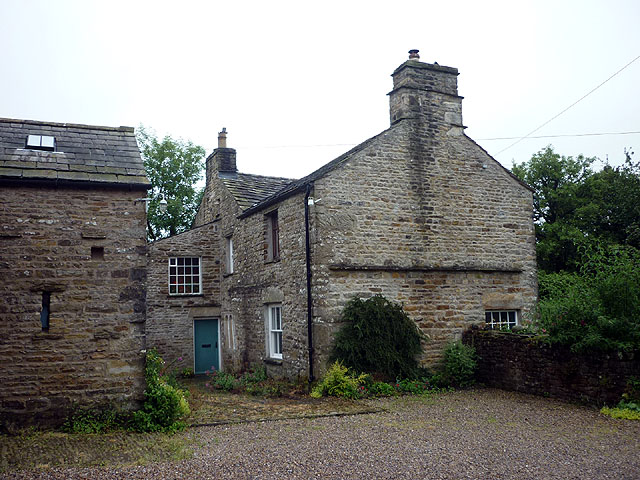
Thursgill, Cumbria
- Overview Map Street View Thursgill is a hamlet / farm on Buckbank Lane, located about 1½ miles north-east of Sedbergh. The house here, a former farmhouse, dates from the late …
Co-Curate Page
Church of the Holy Trinity, Howgill
- Overview Map Street View Inside Holy Trinity Church is located on Howgill Lane, close to Chapel Beck, in Howgill. It was built in 1838, by Edmund Sharpe. It replaced an …
Co-Curate Page
War Memorial, Howgill
- This war memorial is located in the churcyard of Holy Trinity Church, off Howgill Lane in Howgill, Sedbergh. The memorial was unveiled in October 1920 to commemorate seven local servicemen who …
Co-Curate Page
Abbot Holme Bridge
- Overview Map Street View Abbot Holme Bridge carries the road over the River Dee at Abbot Holme, to the south of Sedbergh. The stone bridge dates from the 17th century …
Co-Curate Page
House at East of Abbot Holme
- Overview Map Street View The farmhouse at the East side of Abbot Holme, has an attached cart-shed and barn are thought to date from the mid-18th century, with later alterations. …
Co-Curate Page
House at West of Abbot Holme
- Overview Map Street View The farmhouse at the West side of Abbot Holme, has an attached stable and a cart-shed or barn, and thought to date from the late-17th or …
Co-Curate Page
Old Grammar School (now the School Library)
- Overview Map Street View The Old Grammar School is located by the junction of Back Lane and Loftus Hill, in Sedburgh. The building is dated 1716 on the original doorway, …
Co-Curate Page
Sedbergh War Memorial
- Overview Map Street View Sedbergh War Memorial is located in the churchyard of St Andrew's Church, off Finkle Street, in Sedbergh. The memorial was designed by Sir John Hubert Worthington …
Co-Curate Page
Sedbergh School Chapel
- Overview Map Street View The Chapel of Sedbergh School is located by the junction of Loftus Hill and Busk Lane, in Sedbergh. It was built in 1895-1897, replacing an earlier …
Co-Curate Page
The Cross Keys Temperance Inn
- Overview Map Street View The Cross Keys Temperance Inn is located in Cautley, on Cautley Road (A683), about 4 miles north-east of Sedbergh and 9 miles south-west of Kirkby Stephen. …
Co-Curate Page
Low Haygarth
- Overview Map Street View Low Haygarth is a farm located off Cautley Road, in Cautley, about 4 miles north-east of Sedbergh in Cumbria. It is situated at the foot of …
Co-Curate Page
Hebblethwaite Hall (the Hall)
- Overview Map Street View The Hall at Hebblethwaite Hall Farm is located in Cautley, near Sedbergh. It has a 16th or early 17th century core. The L-plan house was altered …
Co-Curate Page
Mackereth Hill
- Overview Map Street View Mackereth Hill is a former farmhouse in Cautley, located on Cautley Road, by the junction with Hebblethwaite Hall Drive, and close to Low Ridding. It dates …
Co-Curate Page
Milestone (Sedbergh 2), Low Ridding
- Overview Map Street View This old milestone is located on Cautley Road (A683), between Low Ridding and Mackereth Hill, in Cautley, 2 miles north-east of Sedbergh. It is a wrought …
Co-Curate Page
Milestone (Sedbergh 4), High Wardses
- Overview Map Street View This old milestone is located on Cautley Road (A683), near High Wardses, in Cautley, 4 miles north-east of Sedbergh. It is a wrought iron casting, and …
Co-Curate Page
Milestone (Sedbergh 5), Narthwaite
- Overview Map Street View This old milestone is located on Cautley Road (A683), about ½ mile north of the Cross Keys Temerance Inn in Cautley, and south-east of Narthwaite. The milestone …
Co-Curate Page
Old Milestone #2, Narthwaite
- This old milestone, by Cautley Road (A683), just east of Narthwaite, is a short distance south of the milestone for 5 miles to Sedbergh. "This stone is a favourite with …
Co-Curate Page
Millthrop Bridge
- Overview History Map Street View Millthrop Bridge is a stone road bridge over the River Rawthey, to the north of Millthrop and south of Sedbergh. The bridge dates from the …
Co-Curate Page
Archers Hall, Millthrop
- Overview Map Street View Archers Hall, located at the west of Millthrop, is a farmhouse, dated 1681 on the gable of it's rear wing. It is a Grade II* listed …
Co-Curate Page
Frostrow Methodist Chapel
- Overview Map Street View The former Frostrow Methodist Chapel is located on Hawes Road (A684), about 1½ mile south-east of the town of Sedbergh. Frostrow Wesleyan Methodist Chapel was built …
Co-Curate Page
Farfield Mill, Sedbergh
- Overview Map Street View Farfield Mill, by the Clough River, is a former woollen mill, which operated from 1837 to 1992. It is located on a minor road off the …
Co-Curate Page
Former Smithy at Farfield Mills
- Overview Map This cottage at Farfield Mills is a former Blacksmith and Joiner's Shop with an adjacent store room. It dates from the early 19th century and is a Grade …
Co-Curate Page
Garsdale Bridge by Farfield Mill
- Overview Map Garsdale Bridge is located a short distance north-west of Farfield Mill, about a mile east of the town of Sedbergh. It carries a minor road over Clough River. …
Co-Curate Page
Milestone (Sedbergh 1), A684 Hawes Road
- Overview Map Street View This old milestone is located on Hawes Road (A684) east of the junction with Frostrow Lane, 1 mile east of Sedbergh. It is a wrought iron …
Co-Curate Page
Milestone (Sedbergh 2), A684 Hawes Road
- Overview Map Street View This old milestone is located on Hawes Road (A684) south of Garsdale Rigg and north of Low Branthwaites, 2 miles east of Sedbergh. It is a …
Co-Curate Page
Jubilee Drinking Fountain, Sedbergh
- Overview Map Street View The Jubilee Drinking Fountain is located on Finkle Street in Sedbergh, built into the churchyard wall of St Andrew's Church, with stone benches either side of …
Co-Curate Page
New Bridge, Sedbergh
- Overview Map Street View New Bridge (aka Soolbank Bridge) is a bridge at the east of Sedbergh town, which carries Hawes Road (A684) over the River Rawthey. The bridge, with …
Co-Curate Page
Rawthey Bridge (road)
- Overview Map Street View Rawthey Bridge is a bridge which carries Caitley Road (A683) over the River Rawthey in Cautley, north of the town of Sedburgh. The bridge was rebuilt …
Co-Curate Page
Rawthey Bridge (rail), Brigflatts
- Overview Map Rawthey Bridge carried the railway over River Rawthey, near Brigflatts, about 4 miles northof Sedbergh, in Cumbria. It was built 1857-1861, for the Lancaster and Carlisle Railway Company. …
Co-Curate Page
Killington New Bridge, B6256
- Overview Map Street View Killington New Bridge carries the road (B6256) over the River Lune in Cumbria, it is located about 2½ miles south-west of the town of Sedbergh. The …
Co-Curate Page
The Oaks (house), High Oaks, Sedbergh
- Overview Map Street View The Oaks is a large house in the hamlet of High Oaks, near Sedbergh, The 3 storey house is dated 1706 on its porch, but perhaps …
Co-Curate Page
Old Milestone near Killington New Bridge
- Overview Map Street View This old milestone, by the B6256 road, is located about 100 metres east of Killington New Bridge. It indicates 7¾ miles to B.B. (Borrow Bridge) and …

