Topics > County Durham > Civil Parishes in County Durham > Lunedale Civil Parish > Historic Buildings and Monuments in Lunedale
Historic Buildings and Monuments in Lunedale
Listed buildings and scheduled monuments in Lunedale Civil Parish, County Durham, from the National Heritage List for England[1]. In the absence of a published 'local list', some other public buildings of interest may also be included. Use the Search (below) if looking for a specific building / monument.
| Structure | List No. | Grade | Built~ | Note |
|---|---|---|---|---|
| Boundary Stone Next to Fence Circa 30 Feet from Road | 1252825 | II | ||
| Bowbank House and Attached Wing | 1160675 | II | ||
| Byre House and Barn to Left of West Wood Farmhouse | 1323047 | II | ||
| Byre House, 10 Metres East of East End of Laithkirk Church | 1121032 | II | ||
| Cross Hill Field Barn, 320 Metres North West of Rennygill Bridge | 1323046 | II | ||
| Crosshill Stone | 1121031 | II | Meieval | Grains o' th' Beck |
| East Nettlepot Farmhouse and Attached Farmbuildings | 1160745 | II | ||
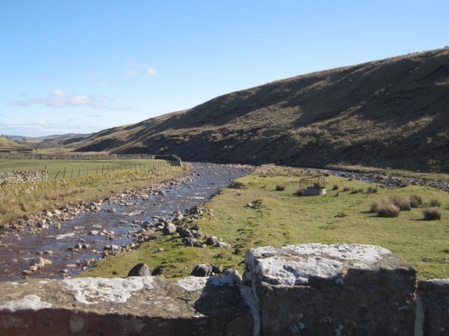
| Far Beck Bridge | 1310493 | II | C18th | Grains o' th' Beck |
| Grains O'th' Beck Bridge | 1121030 | II | C18th | Grains o' th' Beck |
| Hargill Bridge | 1121029 | II | ||
| Laithkirk Church | 1310445 | II | C16th | Parish church |
| Lune Head Cottages | 1121824 | II | ||
| Lune Head House | 1334361 | II | ||
| Lune Railway Viaduct | 1121839 | II | 1868 | Near Laithkirk |
| Milepost, 15 Metres North of Grains O'th'beck Bridge | 1310435 | II | C19th | Grains o' th' Beck |
| Stone Trough and Water Pump, 5 Metres East of East Nettlepot Farmhouse | 1323049 | II | ||
| The Old Vicarage | 1323048 | II | ||
| Thringarth Farmhouse and Farm Buildings to Left | 1121838 | II | ||
| West Wood Farmhouse | 1160653 | II | ||
| Stone circle 650m south west of Lune Head Farm | 1020154 | n/a | Scheduled Monument | |
| Crosshill Stone at Grains o' th' Beck | 1017014 | n/a | Scheduled Monument | |
| Medieval farmstead at Pasture Foot, 510m north west of Bleabeck Force | 1017117 | n/a | Scheduled Monument | |
| Prehistoric settlement and burnt mound at Bleabeck Washfold | 1017118 | n/a | Scheduled Monument | |
| Prehistoric settlements and cairnfield, medieval farmsteads, bloomeries and charcoal pits, 840m south of Cronkley on Bracken Rigg | 1017119 | n/a | Scheduled Monument | |
| Burnt mound 570m east of Widdy Bank Farm | 1017126 | n/a | Scheduled Monument | |
| Medieval farmstead, bloomery, charcoal pits and late prehistoric settlement at Pasture Foot, 300m west of Bleabeck Force | 1019095 | n/a | Scheduled Monument | |
| Hut circle and enclosure 350m north west of Tarn Dub | 1021095 | n/a | Scheduled Monument | |
| Carlbeck Community Centre | not listed | n/a | 1855 | Former school |
Primary source: the National Heritage List for England - NHLE is the register of nationally protected historic buildings and sites in England, including listed buildings, scheduled monuments, protected wrecks, registered parks and gardens, and battlefields. The list is maintained by Historic England. Check NHLE for updates and new entries. Secondary sources: British Listed Buildings and Keys to the Past.
Co-Curate Page
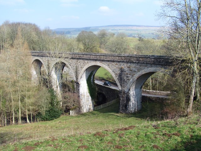
Lune Railway Viaduct
- Overview Map Street View Disused railway viaduct over the River Lune, built in 1868 for the Tees Valley Railway Company. The viaduct is Grade II listed on the National Heritage …
Co-Curate Page
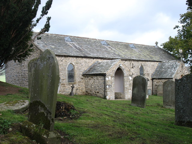
Parish Church, Laithkirk
- The barn was converted to a church in 1577 and became a Parish Church in 1844. It was formerly a Tithe Barn for Lord Fitzhugh, where the people of Mickleton …
Co-Curate Page
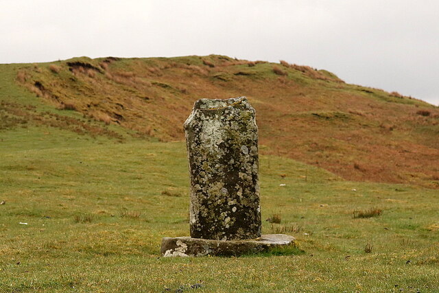
Crosshill Stone, Grains o'th' Beck
- Overview Map Street View Crosshill Stone, is an old wayside cross by the B6276 road, at Grains o'th' Beck, is a Medieval cross base with a (probably) later slab. It …
Co-Curate Page
Grains o'th' Beck Bridge
- Overview Map Street View There is a stone bridge carrying the B6276 road over Long Grain at Grains o'th' Beck in Lunedale. The bridge, with 2 segmental arches, dates from …

Co-Curate Page
Far Beck Bridge, Gain o'th' Beck
- Overview Map Street View Far Beck Bridge is a stone bridge carrying the B6276 road over Lune Head Beck at Grains o'th' Beck in Lunedale. The bridge, with a single segmental arch, dates …
Co-Curate Page
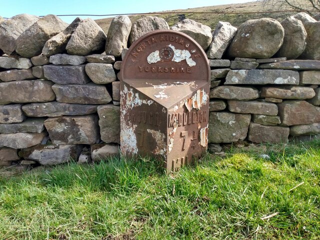
Old Milepost, north of Grains O'th' Beck Bridge
- Overview Map Street View There is an old triangular cast iron milepost on the B6276 road a short distance north of Grains O'th' Beck Bridge. Since local government reorganisation 1974, …
Co-Curate Page
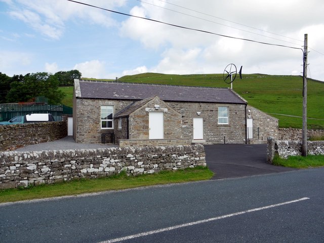
Carlbeck Community Centre, Lunedale
- Overview Map Street View The Carlbeck Centre, run by the Lunedale Community Association, is located near Thirngarth on the B6276 road, about from 2½ miles south-west of Middleton-in-Teesdale and 10 …

Co-Curate Page
Lune Railway Viaduct
- Overview Map Street View Disused railway viaduct over the River Lune, built in 1868 for the Tees Valley Railway Company. The viaduct is Grade II listed on the National Heritage …
Co-Curate Page
Parish Church, Laithkirk
- The barn was converted to a church in 1577 and became a Parish Church in 1844. It was formerly a Tithe Barn for Lord Fitzhugh, where the people of Mickleton …
Co-Curate Page
Crosshill Stone, Grains o'th' Beck
- Overview Map Street View Crosshill Stone, is an old wayside cross by the B6276 road, at Grains o'th' Beck, is a Medieval cross base with a (probably) later slab. It …
Co-Curate Page
Grains o'th' Beck Bridge
- Overview Map Street View There is a stone bridge carrying the B6276 road over Long Grain at Grains o'th' Beck in Lunedale. The bridge, with 2 segmental arches, dates from …
Co-Curate Page
Far Beck Bridge, Gain o'th' Beck
- Overview Map Street View Far Beck Bridge is a stone bridge carrying the B6276 road over Lune Head Beck at Grains o'th' Beck in Lunedale. The bridge, with a single segmental arch, dates …
Co-Curate Page
Old Milepost, north of Grains O'th' Beck Bridge
- Overview Map Street View There is an old triangular cast iron milepost on the B6276 road a short distance north of Grains O'th' Beck Bridge. Since local government reorganisation 1974, …


