Topics > Civil Parishes in Cumbria > Garsdale Civil Parish > Historic Buildings and Monuments in Garsdale Civil Parish
Historic Buildings and Monuments in Garsdale Civil Parish
Listed buildings and scheduled monuments in Garsdale Civil Parish, Cumbria, from the National Heritage List for England[1]. Use the Search (below) if looking for a specific building / monument.
| Structure | List No. | Grade | Built~ | Note |
|---|---|---|---|---|
| Badger Dub and Stable or Shippon Attached to South West | 1384006 | II* | C18th | Farmhouse. C19th modifications. |
| Badger Dub Cottage | 1384007 | II | ||
| Banks and Attached Barn to West | 1384010 | II | ||
| Banks Bridge | 1384009 | II | ||
| Barn 30 Metres North East of Swarth Gill House | 1384052 | II | C18th | Swarthgill House |
| Barn Approximately 10 Metres South East of East Rackenthwaite | 1384020 | II | ||
| Barn Approximately 25 Metres to South West of Garsdale Hall | 1384023 | II | ||
| Barn Approximately 30 Metres South of Dandra Garth | 1384015 | II | C18th | Dandra Garth |
| Barn Approximately 4 Metres North of Clough Farmhouse | 1384057 | II | ||
| Barn Approximately 60 Metres South West of Dandra Garth | 1384016 | II | C18th | Dandra Garth |
| Barn on East Side of Entrance to Low House Farm | 1384033 | II | ||
| Bens Bridge (East Paradise) | 1384011 | II | C17th | Near Dandra Garth |
| Birkrigg and Attached Barn to East | 1384012 | II | ||
| Bridge over Grisdale Beck Approximately 50 Metres East of East Scale Farmhouse | 1384001 | II | ||
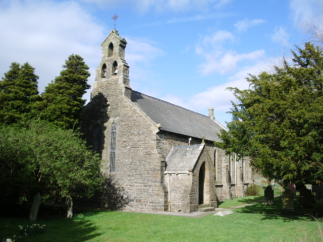
| Church of St John the Baptist | 1384013 | II | 1860 | On the site of an earlier church. |
| Clough Farmhouse | 1384056 | II | ||
| Coach House Opposite Garsdale Hall | 1384024 | II | ||
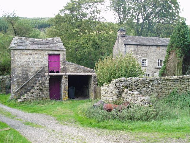
| Dandra Garth | 1384014 | II* | C17th | Large farmhouse |
| Dandrymire Viaduct | 1384058 | II | 1875 | Settle and Carlisle Railway |
| East Coat Weggs Bridge | 1384017 | II | ||
| East Little Town | 1384018 | II | ||
| East Rackenthwaite and Adjoining Barn | 1384019 | II* | C16th | Farmhouse |
| East Scale Farmhouse with Outbuilding Attached to West | 1384002 | II | ||
| Fea Fow | 1384003 | II | ||
| Former Stable Attached to South West Corner of Low House Farmhouse | 1384034 | II | ||
| Garden Shelter Approximately 50 Metres South West of Low House | 1384035 | II | ||
| Garsdale Hall and Attached Barn to East | 1384022 | II | ||
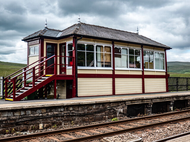
| Garsdale Signal Box | 1412055 | II | 1910 | Garsdale Railway Station |
| Garsdale Street Chapel | 1384025 | II | 1841 | Built as Primitive Methodist chapel |
| High Scale Farmhouse with Attached Stable to West and Barn to East | 1384026 | II | ||
| Hind Keld East | 1384027 | II | ||
| Hind Keld West | 1384028 | II | ||
| Ingheads | 1384029 | II | ||
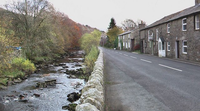
| Kirk Bridge | 1384030 | II | C17th | A684, Garsdale |
| Lindsey Fold Farmhouse | 1384031 | II | ||
| Low House and Barn Attached to Rear | 1384032 | II | ||
| Low House Bridge | 1384036 | II | ||
| Low Scale | 1384037 | II | ||
| Low Scar and Barn Attached to East | 1384038 | II | ||
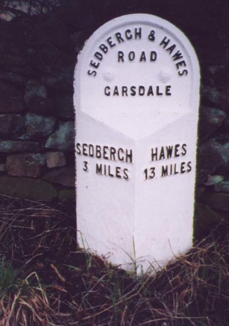
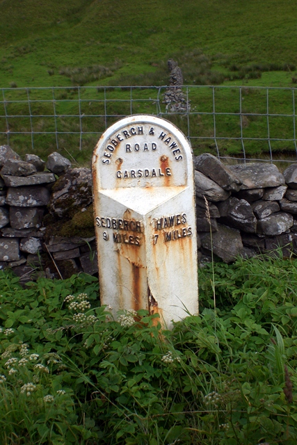
| Milestone (Sedbergh 3) Approximately 10 Metres East of Nether House (Not Included) | 1384039 | II | C19th | A684, Hawes Road |
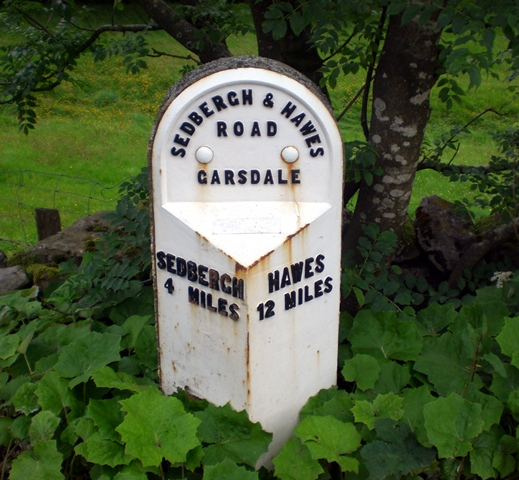
| Milestone (Sedbergh 4) Approximately 20 Metres West of Bellow Hill Turn | 1384040 | II | C19th | A674, Hawes Road |
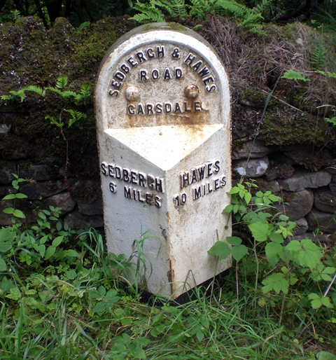
| Milestone (Sedbergh 6) Approximately 75 Metres West of Kirk Bridge | 1384041 | II | C19th | A674, Haws Road |
| Milestone (Sedbergh 7) Approximately 10 Metres West of East Little Town | 1384042 | II | C19th | A684, Hawes Road |
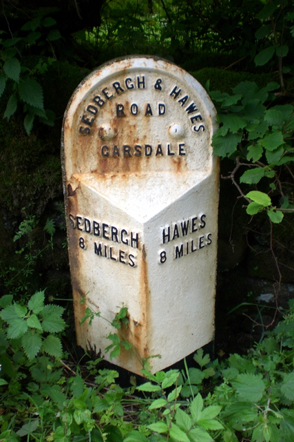
| Milestone (Sedbergh 8) Approximately 5 Metres East of Scar Foot Bridge | 1384043 | II | C19th | A684, Hawes Road |
| Milestone (Sedbergh 9) Approximately 250 Metres East of Harding Bridge (Not Included) | 1384044 | II | C19th | A684, Hawes Road |
| Mill Bridge to North East of Raygill | 1384045 | II | C19th | A684, Hawes Road |
| Potgill House | 1384046 | II | C18th | A684, Hawes Road |
| Privy and Store Approximately 5 Metres South West of East Rackenthwaite | 1384021 | II | ||
| Privy Approximately 5 Metres East of Badger Dub | 1384008 | II | ||
| Railway Bridge Approximately 200 Metres North of Dandrymire Viaduct | 1384059 | II | 1875 | Settle and Carlisle Railway |
| Raygill Farmhouse | 1384047 | II | ||
| Reachey Farmhouse | 1384004 | II | ||
| Scar Foot Bridge | 1384048 | II | ||
| Slack House and Attached Barn | 1384049 | II | ||
| Smithy Chapel to South East of Blades | 1384050 | II | ||
| Swarth Gill | 1384051 | II | C17th | House, Hawes Road |
| Thrush Gill and Attached Barns to East and West | 1384053 | II | ||
| West Coat Weggs | 1384054 | II | ||
| West Little Town and Barn Attached to West | 1384055 | II | ||
| West Scale | 1384005 | II |
Primary source: the National Heritage List for England - NHLE is the register of nationally protected historic buildings and sites in England, including listed buildings, scheduled monuments, protected wrecks, registered parks and gardens, and battlefields. The list is maintained by Historic England. Check NHLE for updates and new entries. Secondary sources: British Listed Buildings.
Co-Curate Page
Church of St John the Baptist, Garsdale
- Overview Map Street View St John the Baptist's Church in Garsdale was built in 1860, replacing an earlier church on this site. The church is Grade II listed on the …
Co-Curate Page
Garsdale Street Chapel
- Overview Map Street View This Methodist chapel is located on Hawes Road (A684) in Garsdale (the settlement along the road is known as 'The Street'). It was built in 1841 as a …
Co-Curate Page
Signal Box, Garsdale Railway Station
- Overview Map Street View The signal box at Garsdale Railway Station was built in 1910 by the Midland Railway Company. In the early hours of Christmas Eve on its year …
Co-Curate Page
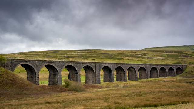
Dandrymire Viaduct
- Overview Map Street View Dandrymire Viaduct carries the Settle and Carlisle Railway line over Dandry Mire, a short distance north-east of Garsdale Station. The coursed sandstone viaduct is about 200m …
Co-Curate Page
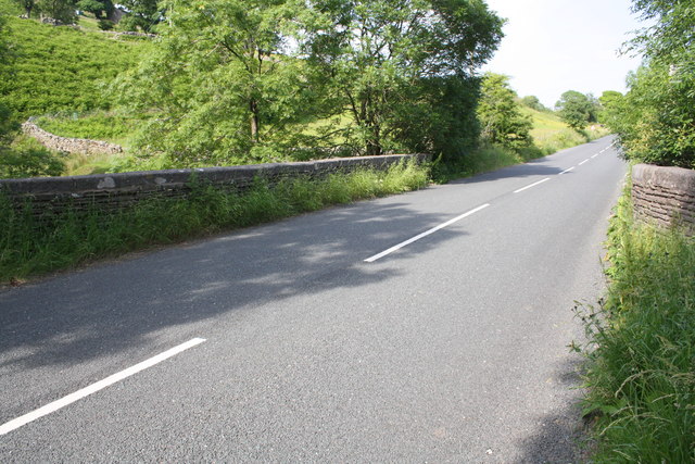
Kirk Bridge, Garsdale
- Overview Map Street View Kirk Bridge carries Hawes Road (the A684) over Clough River in Garsdale. The stone bridge dates from the late 17th or early 18th century. In 1834, …
Co-Curate Page
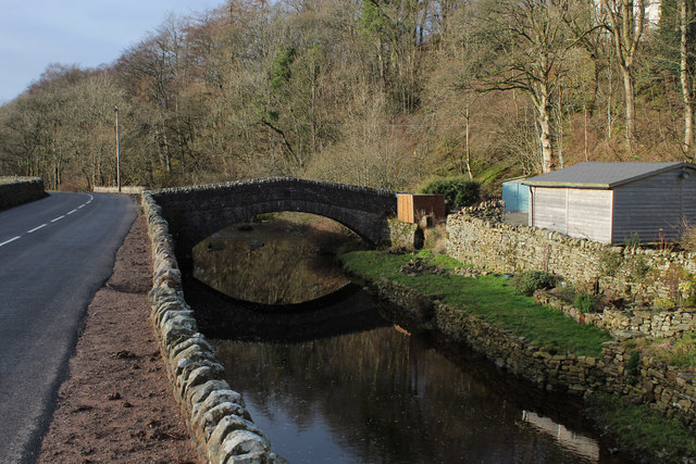
Mill Bridge, A684
- Overview Map Street View Mill Bridge carries Hawes Road (A684) over Clough River, east of Garsdale in Cumbria. The 19th century stone bridge is Grade II listed on the National …
Co-Curate Page
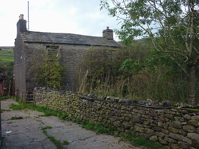
Dandra Garth, Garsdale
- Overview Map Street View Dandra Garth is a fram located at the east of Garsdale in Cumbria, situated off Hawes Road (A864). The 3 storey stone farmhouse probably dates from …
Co-Curate Page
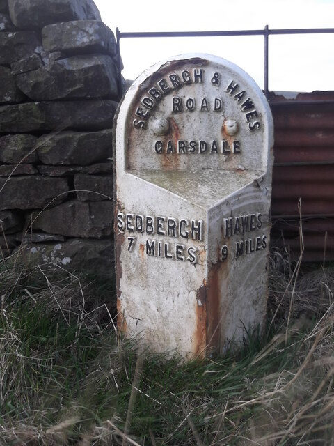
Milestone A684 (Sedbergh 7), Garsdale
- Overview Map Street View This cast-iron milestone is located on Hawes Road (A684), by East Little Town, Garsdale. It dates from the mid to late 19th century and is Grade …
Co-Curate Page
Milestone A684 (Sedbergh 3), Garsdale
- This cast-iron milestone is located on Hawes Road (A684), by Nether House, Garsdale. It dates from the mid to late 19th century and is Grade II listed on the National …
Co-Curate Page
Milestone A684 (Sedbergh 4), Garsdale
- This cast-iron milestone is located on Hawes Road (A684), west of Bellow Hill Turn, Garsdale. It dates from the mid to late 19th century and is Grade II listed on …
Co-Curate Page
Milestone A684 (Sedbergh 6), Garsdale
- This cast-iron milestone is located on Hawes Road (A684), west of Kirk Bridge, Garsdale. It dates from the mid to late 19th century and is Grade II listed on the …
Co-Curate Page
Milestone A684 (Sedbergh 8), Garsdale
- This cast-iron milestone is located on Hawes Road (A684), east of Scar Foot Bridge, Garsdale. It dates from the mid to late 19th century and is Grade II listed on …
Co-Curate Page
Milestone A684 (Sedbergh 9), Garsdale
- This cast-iron milestone is located on Hawes Road (A684), east of Scar Foot Bridge, Garsdale. It dates from the mid to late 19th century and is Grade II listed on …
Co-Curate Page
Potgill Holme, Garsdale
- Overview Map Street View Potgill Holme is a former(?) farm located by Hawes Road (A684) in Garsdale, about 2½ miles east of Sedbergh. The farmhouse dates from the early 18th …
Co-Curate Page
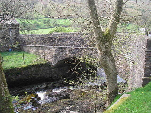
Ben's Bridge, Garsdale
- Overview Map Street View Ben's Bridge is a former packhorse bridge over Clough River, in Garsdale, located off Hawes Road (A684), near Dandra Garth. The bridge is though to date …
Co-Curate Page
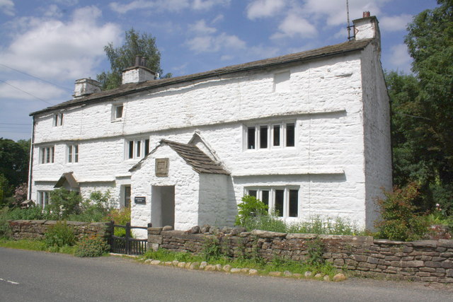
Swarth Gill, Garsdale
- Overview Map Street View Swarthgill (aka Swarth Gill) is a large house on Hawes Road (A684) in Garsdale, located about 4½ miles east of Sedbergh and a similar distance west …

Co-Curate Page
Church of St John the Baptist, Garsdale
- Overview Map Street View St John the Baptist's Church in Garsdale was built in 1860, replacing an earlier church on this site. The church is Grade II listed on the …
Co-Curate Page
Garsdale Street Chapel
- Overview Map Street View This Methodist chapel is located on Hawes Road (A684) in Garsdale (the settlement along the road is known as 'The Street'). It was built in 1841 as a …
Co-Curate Page
Signal Box, Garsdale Railway Station
- Overview Map Street View The signal box at Garsdale Railway Station was built in 1910 by the Midland Railway Company. In the early hours of Christmas Eve on its year …
Co-Curate Page
Dandrymire Viaduct
- Overview Map Street View Dandrymire Viaduct carries the Settle and Carlisle Railway line over Dandry Mire, a short distance north-east of Garsdale Station. The coursed sandstone viaduct is about 200m …
Co-Curate Page
Kirk Bridge, Garsdale
- Overview Map Street View Kirk Bridge carries Hawes Road (the A684) over Clough River in Garsdale. The stone bridge dates from the late 17th or early 18th century. In 1834, …
Co-Curate Page
Mill Bridge, A684
- Overview Map Street View Mill Bridge carries Hawes Road (A684) over Clough River, east of Garsdale in Cumbria. The 19th century stone bridge is Grade II listed on the National …
Co-Curate Page
Dandra Garth, Garsdale
- Overview Map Street View Dandra Garth is a fram located at the east of Garsdale in Cumbria, situated off Hawes Road (A864). The 3 storey stone farmhouse probably dates from …
Co-Curate Page
Milestone A684 (Sedbergh 7), Garsdale
- Overview Map Street View This cast-iron milestone is located on Hawes Road (A684), by East Little Town, Garsdale. It dates from the mid to late 19th century and is Grade …
Co-Curate Page
Milestone A684 (Sedbergh 3), Garsdale
- This cast-iron milestone is located on Hawes Road (A684), by Nether House, Garsdale. It dates from the mid to late 19th century and is Grade II listed on the National …
Co-Curate Page
Milestone A684 (Sedbergh 4), Garsdale
- This cast-iron milestone is located on Hawes Road (A684), west of Bellow Hill Turn, Garsdale. It dates from the mid to late 19th century and is Grade II listed on …
Co-Curate Page
Milestone A684 (Sedbergh 6), Garsdale
- This cast-iron milestone is located on Hawes Road (A684), west of Kirk Bridge, Garsdale. It dates from the mid to late 19th century and is Grade II listed on the …
Co-Curate Page
Milestone A684 (Sedbergh 8), Garsdale
- This cast-iron milestone is located on Hawes Road (A684), east of Scar Foot Bridge, Garsdale. It dates from the mid to late 19th century and is Grade II listed on …
Co-Curate Page
Milestone A684 (Sedbergh 9), Garsdale
- This cast-iron milestone is located on Hawes Road (A684), east of Scar Foot Bridge, Garsdale. It dates from the mid to late 19th century and is Grade II listed on …
Co-Curate Page
Potgill Holme, Garsdale
- Overview Map Street View Potgill Holme is a former(?) farm located by Hawes Road (A684) in Garsdale, about 2½ miles east of Sedbergh. The farmhouse dates from the early 18th …
Co-Curate Page
Ben's Bridge, Garsdale
- Overview Map Street View Ben's Bridge is a former packhorse bridge over Clough River, in Garsdale, located off Hawes Road (A684), near Dandra Garth. The bridge is though to date …


