Topics > Civil Parishes in Cumbria > Ennerdale and Kinniside Civil Parish > Historic Buildings and Monuments in Ennerdale and Kinniside
Historic Buildings and Monuments in Ennerdale and Kinniside
Listed buildings and scheduled monuments in Ennerdale and Kinniside Civil Parish, Cumbria, from the National Heritage List for England[1]. In the absence of a published 'local list', some other public buildings of interest may also be included. Use the Search (below) if looking for a specific building / monument.
| Structure | List No. | Grade | Built~ | Note |
|---|---|---|---|---|
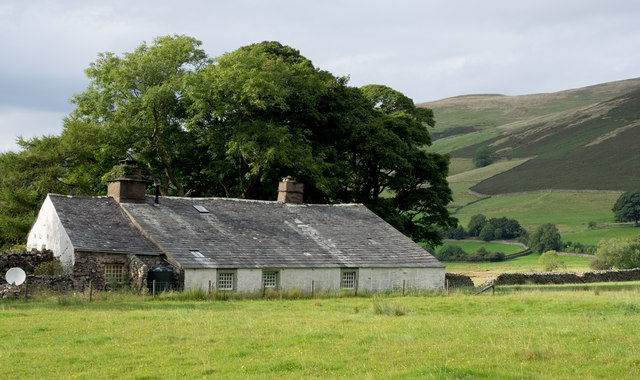
| Bowness | 1086693 | II | C17th | House |
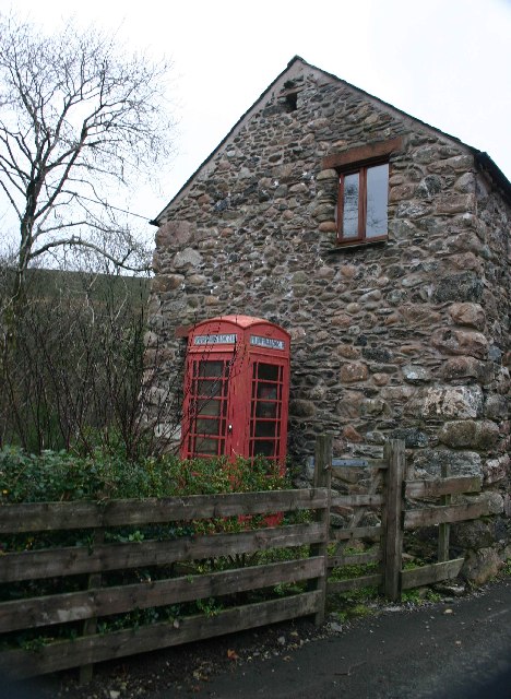
| K6 Telephone Kiosk | 1336048 | II | c.1935 | Croasdale |
| Longmoor Head Farmhouse and Adjoining Stable | 1346573 | II | 1686 | |
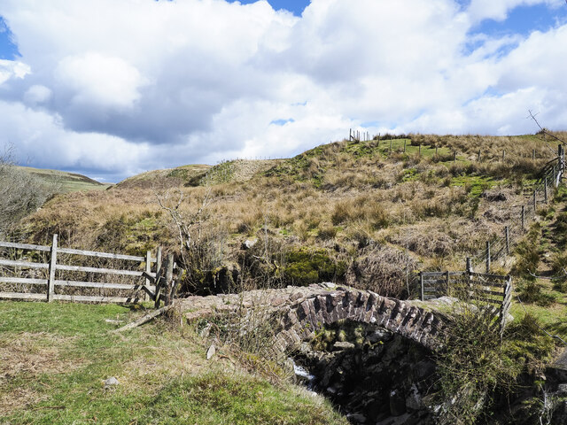
| Monks Bridge over River Calder to South East of Farthwaite Farmhouse | 1086694 | II | C17th | Packhorse bridge |
| Prehistoric cairnfield 1.0km ESE of Low Gillerthwaite | 1408244 | n/a | Scheduled Monument | |
| Smithy Beck settlement: Latterbarrow longhouse 860m north west of Low Gillerthwaite | 1408211 | n/a | Scheduled Monument | |
| Smithy Beck settlement 1.43km north-west of Low Gillerthwaite | 1413845 | n/a | Scheduled Monument | |
| Smithy Beck prehistoric cairnfield, charcoal burning sites, a bloomery and associated earthworks 1.97km WNW of Low Gillerthwaite | 1007235 | n/a | Scheduled Monument | |
| Smithy Beck settlement 1.10km north-west of Low Gillerthwaite | 1007137 | n/a | Scheduled Monument | |
| Woundell Beck medieval settlement, associated field system and cairnfield 890m west of Low Gillerthwaite | 1408266 | n/a | Scheduled Monument | |
| Prehistoric cairnfield and a Romano-British farmstead and its associated field system 1.24 km ESE of Low Gillerthwaite | 1408240 | n/a | Scheduled Monument | |
| Gillerthwaite and Dodsgill Beck medieval settlements, associated field systems and cairnfields 790m ENE and 370m north-east of Low Gillerthwaite | 1408158 | n/a | Scheduled Monument | |
| Medieval shielings at Great Cove, 2.68km south of Low Gillerthwaite | 1408243 | n/a | Scheduled Monument | |
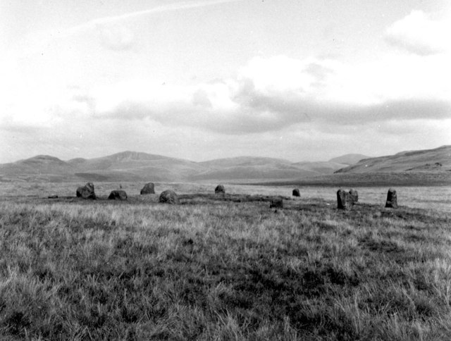
| Lank Rigg round cairn | 1004613 | n/a | Scheduled Monument | |
| Ring cairn on Stockdale Moor 825m west of Pearson's Fold, north of Cawfell Beck | 1020339 | n/a | Scheduled Monument | |
| Cairns and hut circles at the junction of River Calder and Whoap Beck | 1007236 | n/a | Scheduled Monument | |
| Tongue How prehistoric stone hut circle settlements, field systems, funerary cairns, cemetery and cairnfield, Romano-British farmstead, shieling and lynchets | 1018500 | n/a | Scheduled Monument | |
| Town Bank prehistoric stone hut circle settlements, field systems, funerary cairns, ring cairn and cairnfield | 1018502 | n/a | Scheduled Monument | |
| Stockdale Moor prehistoric cairnfields, field systems, unenclosed cairn cemetery, ring cairns and funerary cairns | 1018503 | n/a | Scheduled Monument | |
| Monks Graves prehistoric cairn cemetery, cairnfields, field system, funerary cairns and a ring cairn on Stockdale Moor | 1018504 | n/a | Scheduled Monument | |
| Monk's Bridge 320m south east of Farthwaite | 1016552 | n/a | C17th | Scheduled Monument |
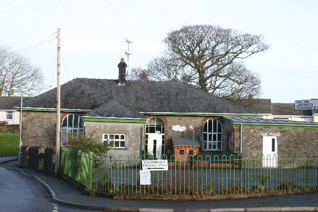
| Ennerdale and Kinniside CofE Primary School | - | not listed | 1878 | Ennerdale Bridge |
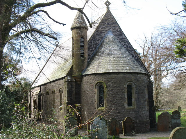
| Church of St Mary | - | not listed | 1856 | Ennerdale Bridge. |
Primary source: the National Heritage List for England - NHLE is the register of nationally protected historic buildings and sites in England, including listed buildings, scheduled monuments, protected wrecks, registered parks and gardens, and battlefields. The list is maintained by Historic England. Check NHLE for updates and new entries. Secondary sources: British Listed Buildings.
Co-Curate Page
K6 Telephone Kiosk, Croasdale
- Overview Map Street View The K6 Telephone Kiosk in Croasdale is Grade II listed on the National Heritage List for England. The domed roof K6 kiosk was designed 1935 by …
Co-Curate Page
Bowness (near Ennerdale Water)
- Overview Map Street View Bowness is a house on the north side of Ennerdale Water. It dates from the late 17th or early 18th century. The building is Grade II …
Co-Curate Page
Ennerdale and Kinniside C of E Primary School
- Overview Map Street View Ennerdale and Kinniside C of E Primary School is located in Ennerdale Bridge. It is a voluntary controlled school, with about 60 pupils aged 3 to 11.[1] …
Co-Curate Page
Church of St Mary, Ennerdale Bridge
- Overview Map Street View Inside St Mary's Church in Ennerdale Bridge dates back to the 16th Century. It was first recoded in 1534 as a chapel of ease, and was largely …

Co-Curate Page
K6 Telephone Kiosk, Croasdale
- Overview Map Street View The K6 Telephone Kiosk in Croasdale is Grade II listed on the National Heritage List for England. The domed roof K6 kiosk was designed 1935 by …
Co-Curate Page
Bowness (near Ennerdale Water)
- Overview Map Street View Bowness is a house on the north side of Ennerdale Water. It dates from the late 17th or early 18th century. The building is Grade II …
Co-Curate Page
Ennerdale and Kinniside C of E Primary School
- Overview Map Street View Ennerdale and Kinniside C of E Primary School is located in Ennerdale Bridge. It is a voluntary controlled school, with about 60 pupils aged 3 to 11.[1] …