Topics > County Durham > Civil Parishes in County Durham > Barningham Civil Parish > Historic Buildings and Monuments in Barningham Civil Parish
Historic Buildings and Monuments in Barningham Civil Parish
Listed buildings and scheduled monuments in Barningham Civil Parish, County Durham, from the National Heritage List for England[1]. Use the Search (below) if looking for a specific building / monument.
| Structure | List No. | Grade | Built~ | Notes |
|---|---|---|---|---|
| Badger Way Stoop, 700 Metres North West of Byers Hill | 1121709 | II | ||
| Barn at East End of the Banks | 1322737 | II | ||
| Barningham House | 1322714 | II | ||
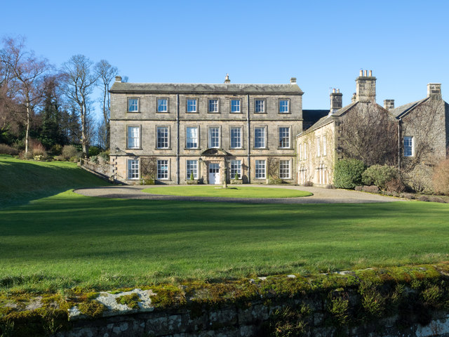
| Barningham Park | 1338635 | II* | C16th | House |
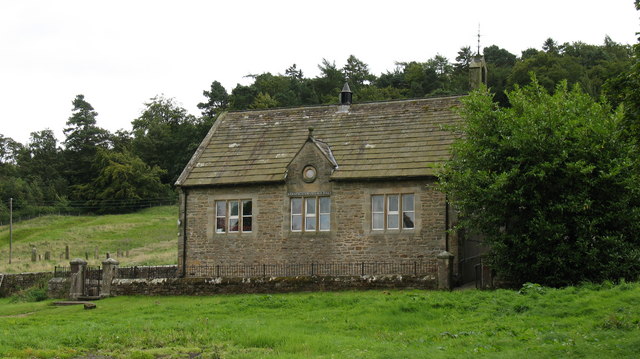
| Barningham Village School | 1160175 | II | 1875 | Former school, now Village Hall |
| Boundary Stone 550 Metres North of Byers Hill | 1338634 | II | ||
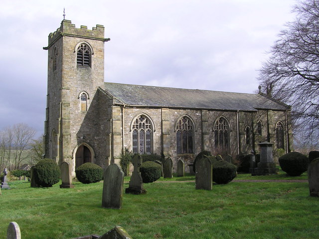
| Church of St. Michael | 1121721 | II | 1816 | On the site of a Medieval church. |
| Church View | 1160150 | II | ||
| Coach House to North of the Old Rectory, with Attached Walls | 1121720 | II | ||
| Cowclose House and Adjacent Byre | 1160281 | II | ||
| Cross Socket by South East Entrance of St Michael's Churchyard | 1121723 | II | ||
| Eastwood Hall | 1121728 | II | ||
| Elim Cottage | 1160047 | II | ||
| Farm Buildings to West of Eastwood Hall | 1121685 | II | ||
| Former Methodist Chapel | 1121727 | II | 1815 | |
| Front Wall and Gatepiers to Barningham Village School | 1121725 | II | ||
| Front Walls and Gatepiers to Heatherlands, Gillbeck House and the Yews | 1160055 | II | ||
| Garden Wall and Attached Outbuildings to West of Barningham Park | 1121710 | II | ||
| Garden Walls and Attached Outbuilding to West of Glebe Farmhouse | 1160080 | II | ||
| Gate Piers at Main Entrance to Barningham Park | 1121713 | II | ||
| Gateway, Approach Walls and South Wall to St Michael's Churchyard | 1310727 | II | ||
| Gillbeck House | 1160041 | II | ||
| Glebe Farmhouse | 1322711 | II | ||
| Group of 3 Grave Slabs 15 Metres North West of St Michael's Churchyard Entry | 1121722 | II | ||
| Ha Ha Wall and Gates to East and South East of Barningham Park | 1121714 | II | ||
| Hawden Headstone 5 Metres North West of St Michael's Churchyard Entry | 1322712 | II | ||
| Heatherlands | 1121718 | II | ||
| Holly Cottage | 1121716 | II | ||
| Ice House 250 Metres South East of Barningham Park | 1121715 | II | ||
| K6 Telephone Kiosk | 1391699 | II | ||
| Kipling Headstone 12 Metres West of St Michael's Churchyard Entry | 1160122 | II | ||
| Manor House Farmhouse | 1338637 | II | ||
| Message Grave Slab 17 Metres South of Church of St Michael | 1160134 | II | ||
| Monument and Adjacent Stone 300 Metres South-West of Moor Gate | 1322716 | II | ||
| Monument on Adam Hill, South East of Barningham Park | 1159690 | II | ||
| Newby House and Attached Wall to West | 1121726 | II | ||
| North and West Walls of Garden to West of Eastwood Hall | 1322735 | II | ||
| Old Bridge over nor Beck, on East Side of Road | 1322736 | II | C18th | |
| Old Cottage and Farmbuildings to West of Park House Farmhouse | 1121687 | II | ||
| Old Limekiln on East Side of Primrose Gill | 1121686 | II | ||
| Old Smithy and Adjacent Cottage | 1322715 | II | ||
| Pair of Outbuildings Flanking Gateway to West of Old Smithy | 1310664 | II | ||
| Pant on Village Green | 1365642 | II | ||
| Park Cottage, with Yard Walls to Rear | 1121711 | II | ||
| Shaw House, with Attached Outbuildings to North West | 1121717 | II | ||
| Stable Block to North West of Barningham Park | 1121712 | II* | ||
| The Hollies | 1160164 | II | ||
| The Laurels | 1160039 | II | ||
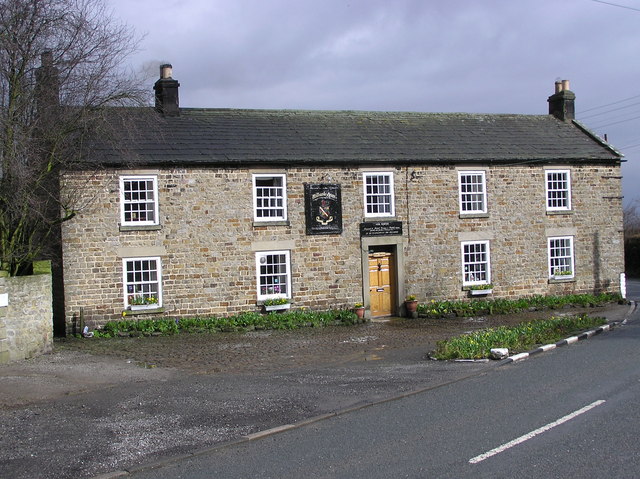
| The Milbank Arms | 1322713 | II | C18th | |
| The Old Rectory | 1160065 | II | ||
| The Yews | 1121719 | II | ||
| Virginia Cottage | 1121724 | II | ||
| Wall and Culvert Entrance to North of Newby House | 1310659 | II | ||
| Wellhead 80 Metres East of Barningham Park | 1310922 | II | ||
| Westoe | 1338636 | II | ||
| Cairn, 545m ESE of Bragg House, Barningham Moor | 1017420 | n/a | Scheduled Monument | |
| Ring cairn 350m east of Haythwaite, Barningham Moor | 1017424 | n/a | Scheduled Monument | |
| Cairn, 650m SSE of Bragg House, Barningham Moor | 1017428 | n/a | Scheduled Monument | |
| Cairn, 625m SSE of Bragg House, Barningham Moor | 1017416 | n/a | Scheduled Monument | |
| Cairnfield on a small knoll at Badger Way Stoop, Barningham Moor | 1017445 | n/a | Scheduled Monument | |
| Carved rock 380m ENE of Bragg House, Barningham Moor | 1017408 | n/a | Scheduled Monument | |
| Carved rock north of Washbeck Green, 570m south of Haythwaite, Barningham Moor | 1017443 | n/a | Scheduled Monument | |
| A cairn, east of Scale Knoll Allotment, 260m south west of Haythwaite, Barningham Moor | 1017438 | n/a | Scheduled Monument | |
| Cairn south of Cross Gill, 645m south east of Black Hill Gate, Barningham Moor | 1017444 | n/a | Scheduled Monument | |
| Cairnfield and associated remains, 250m south east of Bragg House, Barningham Moor | 1017419 | n/a | Scheduled Monument | |
| A cairn and a rubble bank in Scale Knoll Allotment, 510m WSW of Haythwaite, Barningham Moor | 1017412 | n/a | Scheduled Monument | |
| Prehistoric enclosure on the west side of Scale Knoll Gill, 400m WSW of Haythwaite, Barningham Moor | 1017437 | n/a | Scheduled Monument | |
| A cairn and a carved rock on a prominent knoll, south of the road from Barningham to East Hope, 690m WSW of Haythwaite, Barningham Moor | 1017413 | n/a | Scheduled Monument | |
| Prehistoric enclosure 530m and a rubble bank 500m east of Haythwaite in Scale Knoll Allotment, Barningham Moor | 1017436 | n/a | Scheduled Monument | |
| A rock with cups and rings in Scale Knoll Allotment, 790m WSW of Haythwaite, Barningham Moor | 1017411 | n/a | Scheduled Monument | |
| A cairn and a carved rock west of Cowclose Gill, in Scale Knoll Allotment, 460m west of Haythwaite, Barningham Moor | 1017434 | n/a | Scheduled Monument | |
| A cup and groove marked rock, east of Woodclose Gill, 645m north east of Black Hill Gate, Barningham Moor | 1017415 | n/a | Scheduled Monument | |
| Carved rock and cairn in Rowley Intake, 410m south east of Cowclose House, Barningham Moor | 1017422 | n/a | Scheduled Monument | |
| Cairnfield partly enclosed by a bank, on the east side of Woodclose Gill, Scale Knoll Allotment, Barningham Moor, 550m south of Hurst Hill | 1017435 | n/a | Scheduled Monument | |
| A rock with three grooves and five cups with rings, in Scale Knoll Allotment, 800m WSW of Haythwaite, Barningham Moor | 1017409 | n/a | Scheduled Monument | |
| A cairn on the summit of a knoll, in the southwest corner of Scale Knoll Allotment,800m south east of Far East Hope, Barningham Moor | 1017432 | n/a | Scheduled Monument | |
| A carved rock within a large enclosure, 800m north east of Badger Way Stoop, Barningham Moor | 1017418 | n/a | Scheduled Monument | |
| A cairn, a carved rock, and a rubble bank, in the south west corner of Scale Knoll Allotment, 800m south east of Far East Hope, Barningham Moor | 1017431 | n/a | Scheduled Monument | |
| A cup marked rock with 13 cups and a groove, on a knoll in Scale Knoll Allotment, 700m north east of Black Hill Gate, Barningham Moor | 1017410 | n/a | Scheduled Monument | |
| A rock with a cup and a groove, in the south west corner of Scale Knoll Allotment, 790m south east of Far East Hope, Barningham Moor | 1017433 | n/a | Scheduled Monument | |
| A carved rock with one cup, at the east side of Woodclose Gill, in Scale Knoll Allotment, 500m north east of Black Hill Gate, Barningham Moor | 1017429 | n/a | Scheduled Monument | |
| Carved rock and prehistoric enclosure on west side of Scale Knoll Gill, 410m south west of Haythwaite, Barningham Moor | 1017440 | n/a | Scheduled Monument | |
| Carved rocks, cairnfield and rubble banks on the terrace south of Scale Knoll Allotment, immediately east of Black Hill Gate, Barningham Moor | 1017439 | n/a | Scheduled Monument | |
| Carved rock and Romano-British settlement known as Greystone, 250m south of Moorcock Farm, Barningham Moor | 1017421 | n/a | Scheduled Monument | |
| Prehistoric settlement and associated remains including carved rocks and a stone circle 400m north west of How Tallon Cairn, Barningham Moor | 1017441 | n/a | Scheduled Monument | |
| Prehistoric carved rocks and associated remains including cairns and a field system 800m south of Haythwaite, Barningham Moor | 1017442 | n/a | Scheduled Monument | |
| A cairn on a knoll east of Woodclose Gill, in Scale Knoll Allotment, 785m north east of Black Hill Gate | 1017414 | n/a | Scheduled Monument | |
| Unenclosed settlement, 260m south east of Cowclose House, Barnigham Moor | 1017423 | n/a | Scheduled Monument | |
| Ring cairn at the northern end of Scale Knoll Allotment, 750m WNW of Haythwaite | 1017425 | n/a | Scheduled Monument | |
| A carved rock and boulder walling, near the south wall of Scale Knoll Allotment, 500m north east of Black Hill Gate | 1017430 | n/a | Scheduled Monument | |
| A carved rock between The Stang Forest boundary wall and Woodclose Gill, 750m south east of Far East Hope, Barningham Moor | 1017417 | n/a | Scheduled Monument | |
| Medieval church site and churchyard cross, 10m south and 40m south east of St Michael's Church | 1016877 | n/a | Scheduled Monument | |
| How Tallon round barrow and cup marked stones | 1010540 | n/a | Scheduled Monument |
Primary source: the National Heritage List for England - NHLE is the register of nationally protected historic buildings and sites in England, including listed buildings, scheduled monuments, protected wrecks, registered parks and gardens, and battlefields. The list is maintained by Historic England. Check NHLE for updates and new entries.
Secondary sources: British Listed Buildings and Keys to the Past.
Co-Curate Page
Church of St. Michael and All Saints, Barningham
- Overview Map St. Michael's is the Parish Church in Barningham, County Durham. The present church was built in 1816 by the site of an earlier medieval church. The building was …
Co-Curate Page
Village Hall
- Overview Map Street View The Village Hall in Barningham, County Durham, overlooks the village green. The building used to be the village school, built c.1875, and inscribed "ERECTED BY THE FAMILY …
Co-Curate Page
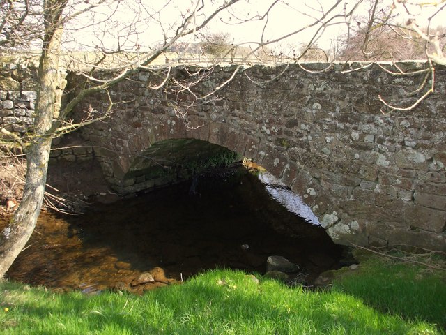
Old Bridge over Nor Beck
- Overview Map Street View The old bridge over Nor Beck, located about half a kilometre north of Barningham, was built in the 18th century. It was once the main route …
Co-Curate Page
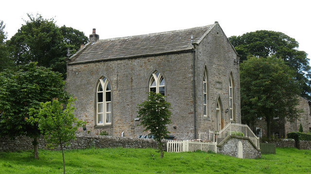
Former Wesleyan Methodist Chapel
- Overview Map Street View The Wesleyan Methodist Chapel in Barningham is dated 1815 and was converted to a residential house in c.1980. "The building is said to have been a …

Co-Curate Page
Church of St. Michael and All Saints, Barningham
- Overview Map St. Michael's is the Parish Church in Barningham, County Durham. The present church was built in 1816 by the site of an earlier medieval church. The building was …
Co-Curate Page
Village Hall
- Overview Map Street View The Village Hall in Barningham, County Durham, overlooks the village green. The building used to be the village school, built c.1875, and inscribed "ERECTED BY THE FAMILY …
Co-Curate Page
Old Bridge over Nor Beck
- Overview Map Street View The old bridge over Nor Beck, located about half a kilometre north of Barningham, was built in the 18th century. It was once the main route …


