Topics > Northumberland > Civil Parishes in Northumberland > Cornhill-on-Tweed Civil Parish > Cornhill Castle (remains of medieval tower house)
Cornhill Castle (remains of medieval tower house)
Map showing Cornhill-on-Tweed, with Cornhill Castle and Scheduled Monument area to the north.
Cornhill Castle, located about ¾mile NNW of Cornhill-on-Tweed in Northumberland, was a medieval tower house and barmkin (a barmkin is the name of a defensive, stone-walled enclosure or courtyard surrounding a medieval tower house, pele tower, or small castle, typically in Scotland and northern England). The site is situated on a small, naturally defended promontory overlooking the River Tweed, which here forms the border with Scotland. The remains of Cornhill Castle are a Scheduled Monument (legally protected).
Scheduled Monument (#1006508): Cornhill Castle
Click the headings below to expand (selected extracts from the Historic England scheduling)
The remains of Cornhill Castle is designated for the following principal reasons:
- Survival: despite the fact that the tower house has been levelled, Cornhill Castle retains significant archaeological deposits.
- Potential: there is still much to learn about medieval settlement and society in the Border areas of England, and this monument adds significantly to our knowledge and understanding of the form and role of defensive settlements at this time.
- Association: the settlement sits between the strongly defended border strongholds of Norham and Wark on Tweed castles (both Scheduled Ancient Monuments) which provide strong contemporary association.
- Period: as a Border stronghold, this monument makes a significant contribution to our knowledge and understanding of the period
Cornhill Castle is first recorded in a document in 1385 when a tower was taken and demolished by the Earl of Fife; that it was rebuilt is evidenced by its inclusion in a list of castles drawn up in 1415 where it is described as the 'Turris de Cornhill' held by Willimi Swinhowe. By 1542, the tower was described as being 'as newe and embattled, covered and put in good repparacion by one Gilbert Swynnhowe' who 'entendeth … to buylde a barmekyn about the said tower'. It was besieged and taken again by the Scots under the French General d'Esse in 1549 when it is described as being a castle 'built after the old fashion, strong and every way tenable'. In 1561 it was still a tower with a barmekin but by 1584 'Cornell Towre' belonging to Thomas Swynney was 'decaied by warres of late tyme'. In 1794, the antiquarian Hutchinson, notes 'a tower near the bridge opposite Linnel House' which he assumes is part of the remains (of Cornhill castle) surrounded with a ditch called 'castle-stone-nich'. A plan of Cornhill estate in 1824 and the Tithe Award Map of 1843 while showing no detail of the castle or its earthworks depicts the field immediately to the south of the site as Castle Stone Nick.
from https://www.gatehouse-gazette…
Cornhill Castle
- The first reference to a tower at Cornhill, is in 1385 when it was taken and demolished by the Scots. A survey of 1541 describes the tower as having been …
Added by
Simon Cotterill

from https://historicengland.org.u…
Cornhill Castle - Scheduling
- The remains of a medieval tower house and barmkin, set within a small, naturally defended promontory demarcated on the south side by a prominent ditched feature. The site is situated …
Added by
Simon Cotterill

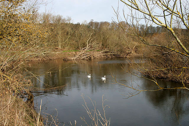
from https://www.geograph.org.uk/p…
Cornhill Castle Mound
- From the south bank of the River Tweed. Photo by Norman MacKillop, 9 April, 2008, Geograph. Licenced: CC BY-SA 2.0
Added by
Simon Cotterill

from https://www.gatehouse-gazette…
Cornhill Castle
- The first reference to a tower at Cornhill, is in 1385 when it was taken and demolished by the Scots. A survey of 1541 describes the tower as having been …
Added by
Simon Cotterill
from https://historicengland.org.u…
Cornhill Castle - Scheduling
- The remains of a medieval tower house and barmkin, set within a small, naturally defended promontory demarcated on the south side by a prominent ditched feature. The site is situated …
Added by
Simon Cotterill
from https://www.geograph.org.uk/p…
Cornhill Castle Mound
- From the south bank of the River Tweed. Photo by Norman MacKillop, 9 April, 2008, Geograph. Licenced: CC BY-SA 2.0
Added by
Simon Cotterill


")