Topics > Heritage Sites > Hadrian's Wall > Aesica (Great Chesters fort)
Aesica (Great Chesters fort)
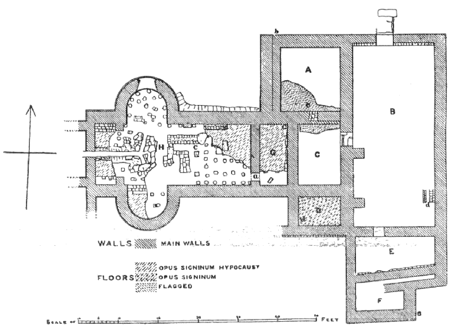
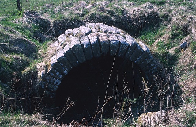
Aesica was a Roman fort on Wall Mile 43 of Hadrian's Wall, located by Great Chesters Farm, about 1½ miles north of Haltwhistle, in Northumberland. The fort was built over the Milecastle 43 after 128 AD to guard the strategic Caw Gap where the Haltwhistle Burn crosses the Wall. The visible remains of the fort include foundations like its west gate, headquarters' strongroom, and defensive ditches. In 1897, a bathhouse was excavated nearby, revealing a rare glazed window and hypocaust under floor heating system, later covered for preservation. Aesica had a remarkable aqueduct system which supplied the fort with water following a 6 mile winding route from the head of Caw Burn, north of the Wall.
Extract from: Great Chesters Roman fort and Hadrian's Wall between the Caw Burn and the track to Cockmount Hill farm in wall miles 42 and 43, Historic England (Scheduled Monument #1010976):
Great Chesters Roman fort, known to the Romans as Aesica, is situated on a low ridge overlooking the Caw Burn to the west. It measures 129m by 109m across its ramparts and encloses an area of 1.36ha. It was one of the last forts to be built, being attached to the rear of the Wall, like Carrawburgh, and was completed between AD 128 and AD 138. It is visible as a series of upstanding turf-covered remains.
The most obvious features are the turf- covered ramparts and the defence ditches, there being no less than four on the most vulnerable west side. The buildings of Great Chesters farm overlie the north east corner of the fort. There have been a number of excavations of the fort, all of which have now been backfilled leaving amorphous mounds and depressions on the ground surface. These excavations have recorded the remains of the headquarters building, commanding officer's house, barrack blocks and lean-to structures against the inside of the fort walls. A vaulted chamber was discovered in the headquarters building which is on display in the centre of the fort.
The west tower of the south gate has yielded an important hoard of jewellery which includes an enamelled brooch shaped as a hare and a gilded bronze brooch considered to be a masterpiece of Celtic art. A number of stone ballista balls were found beside the north west angle-tower when first excavated in 1894. A number of building inscriptions have also been discovered. Traces of the civil settlement outside the fort, usually referred to as the vicus, have been identified to the south and east of the fort. Horsley, writing in 1732, mentioned that, `the outbuildings are most considerable to the south side....there are vast ruins of buildings in this field'. There is a series of building platforms terraced into the slope to the south east of the fort either side of a long scarp running from the south east corner of the fort to the bath house. The most prominent platform contains a section of upstanding exposed walling.
The field to the south of the fort has been ploughed for many years and there are no upstanding features visible except for a slight platform close to the field wall south of the fort. However, bearing in mind the examples of the better known vicus sites at Housesteads and Vindolanda it is expected that the vicus remains at Great Chesters will survive as buried features in the field to the south of the fort and possibly more extensively.
The remains of a bath house 110m due south of the south east angle of the fort were visible until the end of 1987 when they were back filled to the surrounding ground level by English Heritage to avoid further deterioration. The bath house was excavated in 1897 by Gibson and again in 1908 by Simpson and Gibson. The excavations showed that it conformed to the usual design of military bath houses with the various hot, cold and intermediate rooms, together with furnaces, flues and a hypocaust system. It survives as a buried feature.
The exact location and extent of the cemeteries directly associated with this fort are not yet confirmed with certainty. There are two cemeteries to the south of the vallum; one at Wall Mill and one at Four Laws, both of which are the subject of separate schedulings. However, a burial mound is located approximately 240m south west of the fort. This round burial mound is similar in form to burial mounds found near Housesteads and Vindolanda. Together with a number of inscribed tombstones found during excavation of the fort interior it seems that there was a cemetery associated with Great Chesters to the south of the vicus and north of the vallum in addition to the known cemeteries at Wall Mill and Four Laws.
There is a series of cultivation terraces running parallel with the contours approximately 350m west of the fort. There are at least six terraces identifiable in this group all of which survive as upstanding turf-covered earthworks. They are directly comparable to the examples at Housesteads which have been confirmed as Roman in date, which like these are also situated on a south facing slope. Some of these cultivation terraces are overlain by post- medieval narrow ridge and furrow indicating a succession of land use in this area over time.


from Flickr (flickr)
Aesica, Great Chesters fort, West Gate, Hadrian's Wall
Pinned by Simon Cotterill


from Flickr (flickr)
Aesica, Great Chesters fort, southern gateway and Roman altar, Hadrian's Wall
Pinned by Simon Cotterill

from Geograph (geograph)
Aesica (Great Chesters fort) - west wall and gate
Pinned by Simon Cotterill


from Geograph (geograph)
Aesica (Great Chesters fort) - southwest corner tower
Pinned by Simon Cotterill


from Geograph (geograph)
Hadrian's Wall and ditch looking west from Aesica
Pinned by Simon Cotterill


from Geograph (geograph)
Aesica (Great Chesters fort) - southwest tower, west wall and gate
Pinned by Simon Cotterill


from https://commons.wikimedia.org…
Plan of Great Chesters
- Public domain image c/o Wikimedia, from John Collingwood-Bruce: Handbook to the Roman Wall. 12. Ausgabe. Newcastle-upon-Tyne 1897.
Added by
Simon Cotterill


from https://historicengland.org.u…
Great Chesters Roman fort and Hadrian's Wall between the Caw Burn and the track to Cockmount Hill farm in wall miles 42 and 43
- ....Great Chesters Roman fort and Hadrian's Wall between the Caw Burn and the track to Cockmount Hill farm survive well as a series of upstanding and buried remains. Significant information …
Added by
Simon Cotterill


from Flickr (flickr)
Aesica, Great Chesters fort, West Gate, Hadrian's Wall
Pinned by Simon Cotterill
from Flickr (flickr)
Aesica, Great Chesters fort, southern gateway and Roman altar, Hadrian's Wall
Pinned by Simon Cotterill
from Geograph (geograph)
Aesica (Great Chesters fort) - west wall and gate
Pinned by Simon Cotterill
from Geograph (geograph)
Aesica (Great Chesters fort) - southwest corner tower
Pinned by Simon Cotterill
from Geograph (geograph)
Hadrian's Wall and ditch looking west from Aesica
Pinned by Simon Cotterill
from Geograph (geograph)
Aesica (Great Chesters fort) - southwest tower, west wall and gate
Pinned by Simon Cotterill
from https://commons.wikimedia.org…
Plan of Great Chesters
- Public domain image c/o Wikimedia, from John Collingwood-Bruce: Handbook to the Roman Wall. 12. Ausgabe. Newcastle-upon-Tyne 1897.
Added by
Simon Cotterill
from https://historicengland.org.u…
Great Chesters Roman fort and Hadrian's Wall between the Caw Burn and the track to Cockmount Hill farm in wall miles 42 and 43
- ....Great Chesters Roman fort and Hadrian's Wall between the Caw Burn and the track to Cockmount Hill farm survive well as a series of upstanding and buried remains. Significant information …
Added by
Simon Cotterill


