Topics > Heritage Sites > Hadrian's Wall > Wall Mile 46
Wall Mile 46
Hadrian's Wall - Wall Mile 46
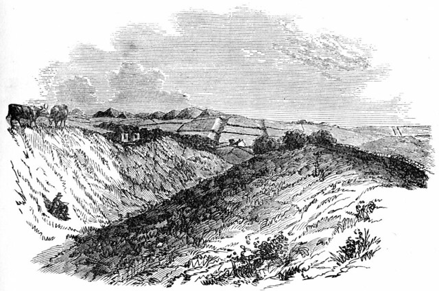
Hadrian's Wall stretches from the east to west coast of England and was an important frontier of the Roman Empire. Building of the wall began in AD 122 and took six years to complete it’s 84 mile (80 Roman mile) length. Soldiers were garrisoned along the line of the wall in large forts, smaller milecastles, and intervening turrets. The Vallum, a large ditch with mounds on either side, ran along the south side of the wall, protecting the rear of the frontier. Hadrian's Wall was designated as a World Heritage Site in 1987.
Wall Mile 46:
- Milecastle 46
- Turret 46a (Holmhead)
- Turret 46b (Wallend)
- Carvoran Fort (Magna)
Nearby Thirlwall Castle, built in the 12th century, is notable as being largely constructed from stone taken from Hadrian's Wall.
Scheduled Monument (#1010991): Carvoran Roman fort and Hadrian's Wall and vallum between the unclassified road to Old Shield and the field boundary west of the fort in wall miles 45 and 46
Click the headings below to expand (selected extracts from the Historic England scheduling)
%
Hadrian's Wall survives as a buried feature throughout this short section. It is traced on the ground as a robber trench, seen as a depression in the turf cover, 2m wide. West of milecastle 46 the Wall remains survive as a low turf-covered stony mound, 0.3m high.
The wall ditch survives very well as a turf-covered earthwork visible on the ground. It averages over 3m in depth throughout its length in this section. The ditch upcast mound, known as the glacis, to the north of the ditch also survives well in this section. It is visible on the ground as a substantial low mound, up to 10m wide in places.
Milecastle 46 is situated just below the crest of a west facing slope overlooking the gap in the Tipalt valley. It was first discovered in 1807 by Lingard and rediscovered in 1910 by Gibson and Simpson. It survives as a faintly visible turf-covered platform, 0.3m high.
The course of the Roman road known as the Military Way, which ran along the corridor between the Wall and vallum linking turrets, milecastles and forts, is known with a fair degree of certainty. Its remains survive below the turf cover. Although there is no surface trace, the space between the Wall and vallum is so confined that its course can be fairly accurately determined. The presence of crossings on the vallum north mound and the absence of breaks at critical points on the mound suggest that the Military Way was not on the north mound or the berm in this section.
The vallum survives as an earthwork visible on the ground throughout this section. To the north of Carvoran fort the vallum veers to the north to approximately 10m from the Wall before reverting to its previous alignment near Tipalt Burn, the deviation coinciding with the length of the larger earlier fort. The south mound has been largely reduced or destroyed by ridge and furrow cultivation. The ditch is mostly silted up in this section though it can be seen 0.4m deep in places. The north mound survives to the north of the modern wall to a height of 0.7m. There are five crossings visible in the north mound, though no traces of ditch causeways survive.
The Stanegate Roman road, which predates the Hadrianic frontier, ran east to west between Corbridge and Kirkbride respectively. It survives largely as a buried feature in this section, visible intermittently as a low ploughed down causeway. For most of its course however there is no surface trace. Its course is known from the first edition Ordnance Survey maps which depict it as a visible feature running parallel and to the immediate south of Carvoran fort.
The Maiden Way is a Roman road which ran north to south probably from the Stanegate outside Carvoran to at least as far as Kirkby Thore to the south. Its remains survive as buried features below the turf cover in this section. However, its course is known as it was marked on the first edition Ordnance Survey map as an upstanding feature. According to this map the junction of the Maiden Way and the Stanegate was to the south east of the south east corner of the fort.
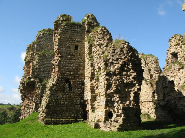
Carvoran Roman fort, known to the Romans as Magna, is situated near the crest of the steep west facing slope overlooking the gap in the Tipalt valley. It guards both this important gap and river crossing and also the junction of the Stanegate and Maiden Way. The fort probably originates from the same period as the Stanegate, around AD 80, and was later included in the Hadrianic frontier, started in AD 122. It is not actually attached to Hadrian's Wall, but lies about 220m to the south of the Wall and 160m south of the vallum.
The stone fort is visible as a turf covered platform with some exposed masonry at the north west angle tower. This fort measures 135m by 111m over the ramparts, enclosing an area just under 1.5ha. Antiquaries who visited the site from 1599 onwards all record the presence of substantial buildings and streets within the stone wall of the fort. A bath house with plastered walls was observed within the south wall near the south west angle.
Aerial photography has revealed the south west corner of a larger predecessor to the visible stone fort between the south west corner of the stone fort and the B6318 road. A faint crop mark running north-south observed south east of Carvoran House may also be associated with this large fort. The Roman name, Magna, is not appropriate for the relatively small stone fort and suggests that it replaced an earlier larger fort. Further Roman ditches were located in 1985 east of Carvoran House which may belong to a third fort.
The pre-Hadrianic history of Carvoran is clearly complex, with the possibility that, like Vindolanda, it consisted initially of a smallish fort which was replaced by one or more larger forts before the construction of the visible small stone fort. As there has been no organised excavation at this site most of what is known comes from chance finds across the site and aerial photography. A number of altars and inscriptions testify to the various detachments which were stationed at the fort at one time or other. These included Hamian archers from Syria and the first cohort of Batavians. Probably the most interesting find to date is the inscription on a stone tablet of a metrical hymn dedicated to the Virgin of the Zodiac, now in the Museum of Antiquities at Newcastle. A well within the fort yielded a set of stag's antlers and an iron javelin head, both in very good condition.
The civil settlement outside the fort, usually referred to as a `vicus', was very extensive according to the accounts of the antiquaries who visited the remains. Horsley, writing in 1732, states clearly that the remains of the vicus were located to the south and west of the fort. No visible remains of the vicus to be seen above ground today, but its remains survive as buried features. The vicus is also testified to, by the numerous dedications to the god Vitiris. A bronze measuring container, or `modius', weighing 26 pounds was discovered in 1915 just north of the north east corner of the fort. It is inscribed and names the emperor Domitian under whom it was made. Domitian died in 96 AD, implying that the Roman occupation at Carvoran probably predated the Wall.
Scheduled Monument (#1010992): Hadrian's Wall and vallum between the field boundary west of Carvoran Roman fort and the west side of the B6318 road in wall mile 46
Click the headings below to expand (selected extracts from the Historic England scheduling)
%
Hadrian's Wall survives as a buried feature throughout most of this section with few remains visible above ground. Traces of it are visible at the east end of this section where it survives as a low spread mound with a maximum height of 0.3m. At the west end of the section between the railway line and the B6318 its course is marked by a robber trench. Elsewhere its remains are masked by the sediments of the floodplain.
The ditch survives well in this section as an earthwork visible on the ground except for the section across the flood plain where a low ploughed down mound occupies the line of the silted ditch. Where extant the ditch measures up to 3.5m deep at the east end and 1.6m deep at the west end. The upcast mound from the ditch, known as the glacis, survives well at the east end of this section as a broad, low turf covered mound to the north of the ditch. Elsewhere its remains are not visible.
The exact location of turret 46a has not yet been confirmed. However, on the basis of the usual spacing it is expected to be situated in the garden to the south west of Holmhead on the east bank of the Tipalt Burn. The turret remains will survive as buried features below the garden
The exact course of the Roman road known as the Military Way, which ran along the corridor between the Wall and vallum linking turrets, milecastles and forts, has not yet been confirmed in this section. Its predicted course is shown on the current Ordnance Survey map.
The vallum survives as an earthwork visible on the ground at the east end of this section. The ditch has a maximum depth of 2.5m, but due to silting is on average 1m deep. The north and south mounds have been ploughed down and now average 0.3m high. Mound crossings are visible along this length. Elsewhere there is no trace above ground of the vallum on the steep ascent from the Tipalt Valley or across the flood plain. A slight depression marks the line of the vallum ditch between the railway and the B6318 road north of the Thirlwall View terrace of houses.
Scheduled Monument (#1010993): Hadrian's Wall, vallum, section of the Stanegate Roman road and a Roman temporary camp between the B6318 road and Poltross Burn in wall miles 46 and 47
Click the headings below to expand (selected extracts from the Historic England scheduling)
%
Hadrian's Wall survives as a buried feature throughout this section except for a short section of Wall less than 10m long which was excavated in 1957 ahead of road widening. The Wall here is consolidated and of broad wall foundation, 3.3m wide and up to 0.5m high. Between this section and milecastle 47 the Wall can be traced as a turf covered scarp measuring 3.5m wide and 0.4m high. A modern wall partly overlies this scarp. West of turret 47b the remains of the Wall are again visible as a turf covered scarp, 0.4m high, with a field wall occupying the centre line of the Wall. In the woodland above the east bank of Poltross Burn the Wall survives as a bank of tumbled stone which has a maximum height of 0.5m. Elsewhere the Wall survives as a buried feature with no remains visible above ground, being overlain by a field wall for most of its course. At Chapel House, farm buildings overlie the course of the Wall.
The exact location of turret 46b has not yet been confirmed. On the basis of the usual spacing its remains would be expected to lie under one of the outbuildings of Wall End farm. No upstanding remains are visible above ground. As archaeological remains have not been confirmed to survive here.
Listed Building, Grade I (#1155916): Milecastles 43, 44, 45 and 46; turrets 42B, 43A, 43B, 44A, 44B, 45A and 45B.

from https://historicengland.org.u…
Hadrian's Wall, vallum, section of the Stanegate Roman road and a Roman temporary camp between the B6318 road and Poltross Burn in wall miles 46 and 47 - List Entry
- ....The monument includes the section of Hadrian's Wall and vallum and their associated features between the B6318 road in the east and the Poltross Burn in the west. All the …
Added by
Simon Cotterill


Co-Curate Page
Thirlwall Castle
- Overview About Thirlwall Castle Map Street View Thirlwall Castle is a 12th-century castle in Northumberland, England, on the bank of the River Tipalt close to the village of Greenhead …


from https://historicengland.org.u…
Carvoran Roman fort and Hadrian's Wall and vallum between the unclassified road to Old Shield and the field boundary west of the fort in wall miles 45 and 46 - List Entry
- .....The monument includes the Roman fort at Carvoran and Hadrian's Wall and vallum and their associated features between the road to Old Shield in the east and the field boundary …
Added by
Simon Cotterill
from https://historicengland.org.u…
Hadrians Wall, Milecastles and Turrets, B6318 - List Entry
- Hadrian's wall; milecastles 43, 44, 45 and 46; turrets 42B, 43A, 43B, 44A, 44B, 45A and 45B. AD 122, reconstructed AD 205. Rubble core with dressed stone faces. Course of …
Added by
Simon Cotterill
from https://historicengland.org.u…
Hadrian's Wall and vallum between the field boundary west of Carvoran Roman fort and the west side of the B6318 road in wall mile 46 - List Entry
- "....The monument includes Hadrian's Wall and vallum and their associated features between the field boundary west of Carvoran Roman fort in the east and the west side of the B6318 …
Added by
Simon Cotterill

from https://historicengland.org.u…
Hadrian's Wall, vallum, section of the Stanegate Roman road and a Roman temporary camp between the B6318 road and Poltross Burn in wall miles 46 and 47 - List Entry
- ....The monument includes the section of Hadrian's Wall and vallum and their associated features between the B6318 road in the east and the Poltross Burn in the west. All the …
Added by
Simon Cotterill
Co-Curate Page
Thirlwall Castle
- Overview About Thirlwall Castle Map Street View Thirlwall Castle is a 12th-century castle in Northumberland, England, on the bank of the River Tipalt close to the village of Greenhead …
from https://historicengland.org.u…
Carvoran Roman fort and Hadrian's Wall and vallum between the unclassified road to Old Shield and the field boundary west of the fort in wall miles 45 and 46 - List Entry
- .....The monument includes the Roman fort at Carvoran and Hadrian's Wall and vallum and their associated features between the road to Old Shield in the east and the field boundary …
Added by
Simon Cotterill
from https://historicengland.org.u…
Hadrians Wall, Milecastles and Turrets, B6318 - List Entry
- Hadrian's wall; milecastles 43, 44, 45 and 46; turrets 42B, 43A, 43B, 44A, 44B, 45A and 45B. AD 122, reconstructed AD 205. Rubble core with dressed stone faces. Course of …
Added by
Simon Cotterill
from https://historicengland.org.u…
Hadrian's Wall and vallum between the field boundary west of Carvoran Roman fort and the west side of the B6318 road in wall mile 46 - List Entry
- "....The monument includes Hadrian's Wall and vallum and their associated features between the field boundary west of Carvoran Roman fort in the east and the west side of the B6318 …
Added by
Simon Cotterill

")
