Topics > Heritage Sites > Hadrian's Wall > Wall Mile 41
Wall Mile 41
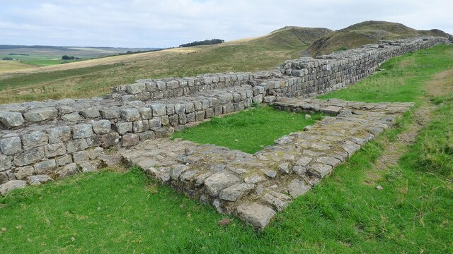
Hadrian's Wall - Wall Mile 41
Hadrian's Wall stretches from the east to west coast of England and was an important frontier of the Roman Empire. Building of the wall began in AD 122 and took six years to complete it’s 84 mile (80 Roman mile) length. Soldiers were garrisoned along the line of the wall in large forts, smaller milecastles, and intervening turrets. The Vallum, a large ditch with mounds on either side, ran along the south side of the wall, protecting the rear of the frontier. Hadrian's Wall was designated as a World Heritage Site in 1987.
Wall Mile 41:
- Milecastle 41 (Melkridge)
- Turret 41a (Caw Gap)
- Turret 41b (Thorny Doors)
Scheduled Monument (#1010973): Hadrian's Wall, associated features and a Romano-British settlement between the road to Steel Rigg car park and the road through Caw Gap in wall miles 39 to 41
Click the headings below to expand (selected extracts from the Historic England scheduling)
%
This section of Wall runs along the crest of the Whin Sill and commands extensive views to the north and south. All the upstanding remains of Hadrian's Wall, the milecastles and the turrets in this scheduling are Listed Grade I. In this section Hadrian's Wall survives intermittently as an upstanding stone wall. It has an average width of 2.2m and the wall face averages 1m high. Sections of wall core still stand up to 1.7m high. A 335m section of upstanding Wall 124m of which has been consolidated on Windshields Crags, including the turf-covered site of milecastle 40, is in the care of the Secretary of State. Elsewhere the Wall survives as a low stony mound with a field wall overlying its course.
The steep crags render a defensive ditch superfluous and so the wall ditch was only constructed in the gaps between the crags. East of Winshields Crags the ditch is visible, surviving between 1.3m and 2.7m deep. The upcast mound from the ditch, usually known as the glacis, measures between 0.3m and 1m high here.
Milecastle 41 is situated to the east of Caw Gap on a west facing slope with wide views to the north and south. It survives as a turf-covered feature. The turf banks covering the walls are 0.5m high internally with an external scarp of up to 1.2m. The remains of robber trenches are marked by depressions. A post-medieval cottage was built on the site of milecastle 41. The remains of an enclosure associated with this cottage and visible as an upstanding feature still abut the east side of the milecastle. Its walls are 1m wide and 0.2m high. Two further platforms to the east may be the remains of buildings. A sub rectangular enclosure is located to the east of the milecastle and also survives as an upstanding feature. The enclosure measures 8.5m by 6m with walls 1m wide and 0.2m high. Earth and stone banks, up to 0.3m high, overlie the Military Way to the south east of the milecastle. All these features are probably part of the same settlement.
See our page: Milecastle 41
The course of the Roman road known as the Military Way, which ran along the corridor linking turrets, milecastles and forts, is known throughout the length of this section even though for the most part there are few visible remains. Its course is marked usually by a slight causeway, up to 0.2m high, or by differing vegetation marks seen in grass colour. This differentiation in vegetation cover reflects differing growing conditions on the compacted road surface. It is best preserved where it crosses a gully running into Green Slack. Here it survives as a built up causeway, 1.7m high and 2m wide. South of milecastle 41 the causeway survives up to 0.7m high with kerb stones on its south side.
The remains of at least three probable Romano-British huts and associated features survive on the south side of Windshields Crags to the west of Green Slack. They were first noted by MacLauchlan in the 1850s. These rectangular buildings measure 5m by 2m internally with boulder walls between 0.5m and 1m wide and 0.5m high.
A shieling survives as an upstanding feature about 140m east of turret 40b. The walls of this triple-celled shieling exist as stony banks averaging 0.2m high. Its south side was built directly over the south kerb of the Military Way. Shielings are small huts used by shepherds on a seasonal basis usually during upland grazing in the summer months. They are characteristic of the medieval period in this area. An important group of shielings is known around Bogle Hole. They survive as rectangular structures averaging 4m across and of variable length. The stone walls survive as turf-covered mounds, 0.2m high.
Scheduled Monument (#1010975): Hadrian's Wall and vallum between the road to Caw Gap and the Caw Burn in wall miles 41 and 42
Click the headings below to expand (selected extracts from the Historic England scheduling)
%
The Wall survives well as an upstanding feature throughout the whole of this section, except for where it has been destroyed by Cawfields Quarry in the west. A number of changes in the thickness of the Wall are evidenced as offsets along this section. These may be the product of separate work gangs building up to each other. The Wall is consolidated for 1240m and averages 1.8m to 2.3m in width and 1.2m to 1.6m in height. It reaches a maximum height of 2.8m near Thorny Doors where it is 12 courses high. Both the north and south face are almost complete with only occasional gaps in the outer face.
Turret 41a is located on the west side of Caw Gap with views to the north and south. It survives as an upstanding stone feature which has been consolidated and is in the care of the Secretary of State. Excavation by Simpson in 1912 located the doorway in the east side of the south wall. It had been dismantled and the Wall built across it during the reign of the Roman emperor Severus. Charlesworth's excavations in 1967 confirmed the deliberate dismantling of the turret and the rebuilding of the Wall across its recess.
See our page: Turret 41a (Caw Gap)
Turret 41b is situated on Cawfield Crags west of Thorny Doors. It survives as a buried feature. It was located and excavated in 1912 by Simpson. The turret is included as part of the Wall in the care of the Secretary of State.
Scheduled Monument (#1010974): The vallum between the road to Steel Rigg car park and the road in Caw Gap in wall miles 39, 40 and 41
Click the headings below to expand (selected extracts from the Historic England scheduling)
%
The vallum follows an almost level course throughout this section in the low ground south of Windshields Crags and north of the ridge which carries the Stanegate Roman road. The vallum survives well and is visible as an upstanding earthwork. The ditch averages 1m in depth, while the north and south mounds, which have been substantially reduced, average 0.3m in height. Near Shield on the Wall the ditch has a maximum depth of 2m and the north and south mounds are 1m high. At Twice Brewed the B6318 overlies the vallum, running between the ditch and the southern mound. Parts of the north mound and ditch here have been destroyed by quarrying.


from https://historicengland.org.u…
The vallum between the road to Steel Rigg car park and the road in Caw Gap in wall miles 39, 40 and 41
- ...The monument includes the section of vallum between the west side of the road to Steel Rigg car park in the east and the west side of the road to …
Added by
Simon Cotterill
from https://historicengland.org.u…
Hadrian's Wall, associated features and a Romano-British settlement between the road to Steel Rigg car park and the road through Caw Gap in wall miles 39 to 41 - List Entry
- ....The monument includes the section of Hadrian's Wall and its associated features between the west side of the road to Steel Rigg car park in the east and the west …
Added by
Simon Cotterill
from https://historicengland.org.u…
Hadrian's Wall and vallum between the road to Caw Gap and the Caw Burn in wall miles 41 and 42
- ....The monument includes the section of Hadrian's Wall and vallum and their associated features between the road to Caw Gap in the east and the Caw Burn in the west. …
Added by
Simon Cotterill

from https://historicengland.org.u…
The vallum between the road to Steel Rigg car park and the road in Caw Gap in wall miles 39, 40 and 41
- ...The monument includes the section of vallum between the west side of the road to Steel Rigg car park in the east and the west side of the road to …
Added by
Simon Cotterill
from https://historicengland.org.u…
Hadrian's Wall, associated features and a Romano-British settlement between the road to Steel Rigg car park and the road through Caw Gap in wall miles 39 to 41 - List Entry
- ....The monument includes the section of Hadrian's Wall and its associated features between the west side of the road to Steel Rigg car park in the east and the west …
Added by
Simon Cotterill
from https://historicengland.org.u…
Hadrian's Wall and vallum between the road to Caw Gap and the Caw Burn in wall miles 41 and 42
- ....The monument includes the section of Hadrian's Wall and vallum and their associated features between the road to Caw Gap in the east and the Caw Burn in the west. …
Added by
Simon Cotterill