Topics > Heritage Sites > Hadrian's Wall > Wall Mile 39
Wall Mile 39
Hadrian's Wall - Wall Mile 39
Hadrian's Wall stretches from the east to west coast of England and was an important frontier of the Roman Empire. Building of the wall began in AD 122 and took six years to complete it’s 84 mile (80 Roman mile) length. Soldiers were garrisoned along the line of the wall in large forts, smaller milecastles, and intervening turrets. The Vallum, a large ditch with mounds on either side, ran along the south side of the wall, protecting the rear of the frontier. Hadrian's Wall was designated as a World Heritage Site in 1987.
Wall Mile 39:
- Milecastle 39 (Castle Nick)
- Turret 39A (Peel Crag)
- Peel Gap Turret
- Turret 39B (Steelrigg)
Scheduled Monument (#1010966): Hadrian's Wall and associated features between the field boundary west of turret 37a and the road to Steel Rigg car park in wall miles 37, 38 and 39
Click the headings below to expand (selected extracts from the Historic England scheduling)
%
The monument includes the section of Hadrian's Wall and its associated features between the field boundary west of turret 37a in the east and the west side of the road to Steel Rigg car park in the west. Hadrian's Wall follows the crest of the Whin Sill throughout this section, which includes the steep rock outcrops of Hotbank Crags, Highshield Crags and Peel Crags. There are extensive views to north and south all along this section.
Hadrian's Wall survives well as an exposed and consolidated wall for the larger part this section averaging 2m wide and 1.4m high. It reaches a maximum height of 2.75m at Sycamore Gap where there are 11 courses extant. Here there are also traces of original mortar and whitewash along the north face and in the wall core. Above Sycamore Gap on its west side is a section of bypassed broad wall foundations which measure 2.75m wide and two courses high on the east side and a single course high on the west side and is now consolidated and on display.
Above Peel Crags the Wall is in poor condition though it stands up to 2.7m on its north side and up to 1.7m on the south side. Elsewhere in this section the Wall survives as a turf-covered mound averaging 2m wide and 1m high. Modern field walls overlie these turf-covered stretches of Wall.
The wall ditch was only constructed in the gaps between the crags, as the steep craggy scarps render a ditch superfluous here. Where it was constructed the ditch survives as a visible feature. At Milking Gap the ditch averages 10m wide and 1m deep. Excavations by Crow in 1986 to the west of the Roman tower at Peel Gap showed the ditch to be 9m wide and 2.3m deep with a level berm 9.5m across. At Peel Gap the ditch is less well preserved as a surface feature, though it averages 1m in depth. The ditch upcast mound, usually known as the `glacis', is here visible only as a slight counterscarp. The glacis is better preserved at Milking Gap where it averages 6m wide.
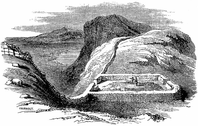
Milecastle 39, known as Castle Nick, is positioned in a steep sided gap between Highshield Crags and Peel Crags with views to the north and south. It survives well as an upstanding stone feature and is now consolidated. It measures 19m long and about 15.5m across, though its overall width varies slightly at each end. The walls stand up to 1.75m high.
The milecastle was partly excavated by Clayton and later by Simpson. However, excavations by Crow between 1985 and 1987 produced a detailed understanding of the milecastle and its internal structures and their development over time. Early barrack blocks were later replaced by individual small buildings with curved porches, probably designed as wind breaks.
The pottery sequence showed that the occupation of the milecastle was continuous and ended probably sometime in the fourth century AD. An 18th century milking parlour was later constructed in the north west part of the milecastle. The milecastle excavation produced many small finds including pottery, coins, and metalwork which included short swords and lances, together with gaming boards and pieces.
See our page: Milecastle 39 (Castle Nick)
Turret 39a is located on the crest of Peel Crags and commands wide views in all directions. It is visible as a slight rectangular hollow about 0.2m deep. The turret was located in 1909 and excavated in 1911 by Simpson. Its walls were of narrow gauge and were found to have been demolished and the Wall built over its entrance indicating that it fell out of use during the Roman period. A platform, probably for a ladder, was positioned in the south west corner. The remains of a man and a woman were found buried in the north west corner. Burial in such a place was against Roman law and as such these could be the remains of an unlawful event.
A Roman tower is positioned in Peel Gap on Hadrian's Wall with limited views to the north and south. Unusually it is located between the two turrets 39a and 39b. It survives as consolidated stone foundations. It was discovered by Crow during investigation and clearance of the Wall in this section in 1986.
This additional tower was later than the Hadrianic narrow wall. Finds from inside and outside the tower showed that it had a similar structural history and use to the neighbouring turrets. Hearths and a ladder platform were found in the interior.
Wall mile 39 is a particularly long one as the distance between turrets 39a and 39b exceeds by over 200m the normal spacing of 494m from turret to turret. The Peel Gap tower lies exactly midway between these turrets implying that spacing was the most important factor determining its location. As an observation post it is in a very poor position.
See our page: Peel Gap Tower
A medieval tower is located in Peel Gap abutting Hadrian's Wall. It was probably part of the original pele tower which gave its name to the modern farmhouse and adjacent crag. It survives as a slight platform with excavation trenches and spoil heaps, up to 0.4m high. It was excavated by Simpson in 1911 who recovered medieval green glazed pottery from the interior.
The course of the Roman road known as the Military Way, which ran along the corridor between the Wall and the vallum linking turrets, milecastles and forts, survives well as a linear causeway throughout this section. Some stone is visible on the south scarp where it has been built up to make a level surface. This scarp appears to have had a stone revetment. The south scarp averages 0.4m in height, although it reaches up to 1.2m high in places. West of Peel Farm the Military Way is overlain by the road to Steel Rigg car park.
There are ten shielings located within this section of the Wall. Shielings are small shepherds' huts which were used on a seasonal basis usually during upland grazing in the summer months. They are characteristic of the medieval period in this area. There are five free standing shielings located between Castle Nick and Sycamore Gap. Their dry stone walls average 1m in width and 0.4m high.
A group of three shielings with multiple phases are located 50m east of milecastle 39 abutting the south face of Hadrian's Wall. These were discovered during excavations between 1985 and 1987 by Crow. Their walls average 0.6m wide and 0.4m high. They are now consolidated and are visible as stone features.
Scheduled Monument (#1010973): Hadrian's Wall, associated features and a Romano-British settlement between the road to Steel Rigg car park and the road through Caw Gap in wall miles 39 to 41
Click the headings below to expand (selected extracts from the Historic England scheduling)
%
Turret 39b is located on the west side of the road to Steel Rigg car park at the foot of an east facing slope. It commands views across the hollow to the north and to the line of the Stanegate Roman road to the south. The turret survives as a buried feature. Excavation in 1912 by Simpson showed that it measured 5.75m north to south by 5m across. The turret was built with broad wing walls attaching it to the main Wall line. These wing walls were shown to have been built over with narrow wall. At some point the north wall of the turret was demolished and Hadrian's Wall rebuilt across it to its full width.
Scheduled Monument (#1010972): The vallum and a British settlement between the field boundary west of turret 37a and the road to Steel Rigg car park, in wall miles 37, 38 and 39
Click the headings below to expand (selected extracts from the Historic England scheduling)
%
The vallum survives well as an upstanding earthwork throughout most of this section. Where extant the north mound averages 1.7m high, the south mound 1m high and the ditch 1.2m deep. Between High Shield and Twice Brewed the B6318 road overlies parts of the vallum. However, where it runs along the line of the vallum the road lies on the south berm, which has resulted in some disturbance to the monument. To the south of Hotbank Crags the remains of the vallum have been reduced and the ditch silted up, though its course can still be traced.
Scheduled Monument (#1010974): The vallum between the road to Steel Rigg car park and the road in Caw Gap in wall miles 39, 40 and 41
Click the headings below to expand (selected extracts from the Historic England scheduling)
%
The vallum follows an almost level course throughout this section in the low ground south of Windshields Crags and north of the ridge which carries the Stanegate Roman road. The vallum survives well and is visible as an upstanding earthwork. The ditch averages 1m in depth, while the north and south mounds, which have been substantially reduced, average 0.3m in height. Near Shield on the Wall the ditch has a maximum depth of 2m and the north and south mounds are 1m high. At Twice Brewed the B6318 overlies the vallum, running between the ditch and the southern mound. Parts of the north mound and ditch here have been destroyed by quarrying.
Co-Curate Page
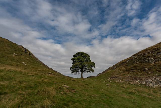
Sycamore Gap
- Sycamore Gap is a dramatic dip in Hadrian’s Wall, near Milecastle 39, on land owned by the National Trust and within the Northumberland National Park. The iconic sycamore tree which …


from https://historicengland.org.u…
Hadrians Wall Milecastles and Turrets
- Hadrian's wall; milecastles 39 and 40; turrets 38A, 38B, 39A, 39B and 40A. AD 122, reconstructed AD 205. Rubble core with dressed stone faces. Course of wall runs west from …
Added by
Simon Cotterill


from Flickr (flickr)
Hadrian Wall, heading to Milecastle 39 and first glimpse of Highshield Crags and Crag Lough
Pinned by Simon Cotterill

from Flickr (flickr)
Hadrian Wall, walking east along Peel Crags to Milecastle 39
Pinned by Simon Cotterill

from https://historicengland.org.u…
The vallum between the road to Steel Rigg car park and the road in Caw Gap in wall miles 39, 40 and 41
- ...The monument includes the section of vallum between the west side of the road to Steel Rigg car park in the east and the west side of the road to …
Added by
Simon Cotterill
from https://historicengland.org.u…
Hadrian's Wall, associated features and a Romano-British settlement between the road to Steel Rigg car park and the road through Caw Gap in wall miles 39 to 41 - List Entry
- ....The monument includes the section of Hadrian's Wall and its associated features between the west side of the road to Steel Rigg car park in the east and the west …
Added by
Simon Cotterill
from https://historicengland.org.u…
Hadrian's Wall and associated features between the field boundary west of turret 37a and the road to Steel Rigg car park in wall miles 37, 38 and 39 - List Entry
- ...Hadrian's Wall and its associated features between the field boundary west of turret 37a and the road to Steel Rigg car park survive well as a series of buried and …
Added by
Simon Cotterill
from https://historicengland.org.u…
The vallum and a British settlement between the field boundary west of turret 37a and the road to Steel Rigg car park, in wall miles 37, 38 and 39 - List Entry
- ...The vallum and associated features, including the British settlement, between the field boundary west of turret 37a and the road to Steel Rigg car park survive well as a series …
Added by
Simon Cotterill

from Flickr (flickr)
Hadrian's Wall, heading up to Highshield crags looking back to Sycamore Gap, Peel Crags and Windshield Crags in the distance
Pinned by Simon Cotterill


Co-Curate Page
Sycamore Gap
- Sycamore Gap is a dramatic dip in Hadrian’s Wall, near Milecastle 39, on land owned by the National Trust and within the Northumberland National Park. The iconic sycamore tree which …
from https://historicengland.org.u…
Hadrians Wall Milecastles and Turrets
- Hadrian's wall; milecastles 39 and 40; turrets 38A, 38B, 39A, 39B and 40A. AD 122, reconstructed AD 205. Rubble core with dressed stone faces. Course of wall runs west from …
Added by
Simon Cotterill
from Flickr (flickr)
Hadrian Wall, heading to Milecastle 39 and first glimpse of Highshield Crags and Crag Lough
Pinned by Simon Cotterill
from Flickr (flickr)
Hadrian Wall, walking east along Peel Crags to Milecastle 39
Pinned by Simon Cotterill
from https://historicengland.org.u…
The vallum between the road to Steel Rigg car park and the road in Caw Gap in wall miles 39, 40 and 41
- ...The monument includes the section of vallum between the west side of the road to Steel Rigg car park in the east and the west side of the road to …
Added by
Simon Cotterill
from https://historicengland.org.u…
Hadrian's Wall, associated features and a Romano-British settlement between the road to Steel Rigg car park and the road through Caw Gap in wall miles 39 to 41 - List Entry
- ....The monument includes the section of Hadrian's Wall and its associated features between the west side of the road to Steel Rigg car park in the east and the west …
Added by
Simon Cotterill
from https://historicengland.org.u…
Hadrian's Wall and associated features between the field boundary west of turret 37a and the road to Steel Rigg car park in wall miles 37, 38 and 39 - List Entry
- ...Hadrian's Wall and its associated features between the field boundary west of turret 37a and the road to Steel Rigg car park survive well as a series of buried and …
Added by
Simon Cotterill
from https://historicengland.org.u…
The vallum and a British settlement between the field boundary west of turret 37a and the road to Steel Rigg car park, in wall miles 37, 38 and 39 - List Entry
- ...The vallum and associated features, including the British settlement, between the field boundary west of turret 37a and the road to Steel Rigg car park survive well as a series …
Added by
Simon Cotterill
from Flickr (flickr)
Hadrian's Wall, heading up to Highshield crags looking back to Sycamore Gap, Peel Crags and Windshield Crags in the distance
Pinned by Simon Cotterill


