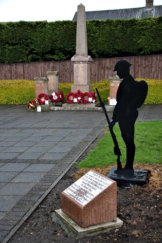
Belmont War Memorial, Carrville, County Durham, England.
")

-
Description
Belmont is a suburb forming the north-eastern parts of the city of Durham, England. Belmont Parish covers four old coal mining villages of Belmont, Carrville, Broomside and Gilesgate Moor, which have been joined together by indsutrial and suburban devleopments since the 1950s. As such Belmont can be used either to refer narrowly to the old village area, or the wider parish, particularly the parts (Belmont, Carrville and Broomside) to the east of the A1(M) motorway which bisects the area. At the 2011 census, the parish had a population of 8,881. Belmont was a largely agricultural area within the parishes of St Giles Church, Durham and Pittington, but industrial developments - mainly coal mining - brought development through the second half of the nineteenth century. A number of collieries were sunk in the area and the largest, Belmont Colliery, took its name from the 1820s-built Belmont Hall (previously and now again known as 'Ramside Hall'). Belmont was surrounded by a number of other collieries, including Kepier Grange, Carrville, Dragonville, Broomside and Gilesgate Moor These together formed the new Belmont Parish in 1852, and the boundaries of the Parish today still include these districts. However by the late nineteenth century the majority of the collieries in this part of Durham had closed (those some small ones stayed open until the 1920s), and many of the houses built just decades earlier were demolished. The Grange Ironworks became the main employer in the villages, but in the absence of the coalmines the villages did not grow significantly and even saw some population loss through this time. The Ironworks too closed in the 1920s. Belmont, Broomside, Carrville and Gilesgate Moor were still village-like until the 1950s, when significant expansion of suburban housing in Durham City occurred. The High Grange Estate in Gilesgate Moor, built in the 1960s, greatly expanded the north and western parts of the parish and filled in some of the area between Gilesgate and Belmont village, though the A1 motorway, which opened in 1965, had the effect of splitting the parish somewhat, cutting off the eastern part (Belmont, Carrville and Broomside) from the western parts (Gilsegate Moor and High Grange). Further signficiant suburban developments in Belmont and Carrville, particualrly to the south of Broomside Lane, grew the area's population between 1970 and 2000, while the Dragonville area of Gilesgate Moor saw first industrial and then later retail growth from the 1970s onwards; today the district is home to a number of large shopping centres and supermarkets. Belmont Community Centre, with a small park, was constructed in 1971 and provides a hub for community activities, including the home of the parish council. To the north of the area, Belmont Business Park with New Ferens Park football stadium opened in 1995, and this site has continued to grow with further industrial developments into the 2010s. -
Owner
millicand@rocketmail.com -
Source
Flickr (Flickr) -
License
What does this mean? All Rights Reserved (Seek permission to reuse)
-
Further information
Link: https://www.flickr.com/photos/98336874@N04/52468141508/
Resource type: Image
Added by: Pat Thomson
Last modified: 3 years, 3 months ago
Viewed: 557 times
Picture Taken: 2021-04-29T09:54:36 -
Co-Curate tags


