Topics > Civil Parishes in Cumbria > Burtholme Civil Parish > Parish of Lanercost Abbey, 1848
Parish of Lanercost Abbey, 1848
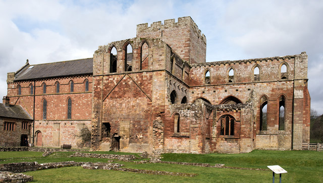
LANERCOST-ABBEY (St. Mary Magdalene), a parish, in the union of Brampton, Eskdale ward, E. division of Cumberland, 2½ miles (N.E.) from Brampton; containing, with the townships of Askerton, Burtholme, Kingwater, and Waterhead, 1,582 inhabitants. This place is identified as the site of the Roman station Amboglana, where was posted the Cohors Prima Aelia Dacorum, and of which considerable vestiges remain. The area occupies an extensive plain, with a precipitous descent to the river Irthing, and is 120 yards from north to south, and 80 from east to west. Several votive altars have been found, dedicated to Jupiter Optimus Maximus, and other Roman deities; a fragment of the great Roman wall is yet standing at Harehill, about five yards in length, and ten feet high; and there are numerous other indications of Roman occupation. The abbey of Lanercost was founded in 1169, by Robert de Vallibus, Lord of Gillesland, for a prior and monks of the order of St. Augustine, and dedicated to St. Mary Magdalene. It was frequently visited by Edward I.; and was partly destroyed by fire in 1296, but was restored, and continued to flourish till the Dissolution, when its revenue was estimated at £79. 19., and the site was granted to Thomas, Lord Dacre, a descendant of the founder. In 1716 the priory estate reverted to the crown, under which it is now held on lease by the Earl of Carlisle. The remains, which are beautifully situated on the north bank of the river, consist of the conventual church, which has been appropriated as the church of the parish, part of the cloisters, and refectory, and other buildings. In 1311, Robert Bruce lay with his army encamped here for three days.
The parish is bounded on the east and south by the Irthing, and intersected by the Kingwater and several smaller streams; it comprises by computation 30,000 acres, of which about two-thirds are pasture, and the remainder arable and woodland. Its surface is pleasingly varied, and in many parts highly picturesque. The soil in the lower lands is a rich loam, alternated with; sand, and the steep banks that inclose the vales of Kingwater and Irthing produce fine crops of grain; the substratum abounds with limestone. The living is a perpetual curacy; net income, £107; patron and impropriator, the Earl of Carlisle. The tithes were commuted for land in 1802. The church is principally in the early English style, with Norman portions, of which the western doorway is a highly-enriched specimen. In the transepts, which are covered with a profusion of ivy and other plants, are several tombs of the Howards and Dacres, much disfigured by exposure to the air; and in part of the ancient cemetery, which has been converted into gardens, are numerous monuments, and stone coffins scattered among the trees. The roof of the church fell in, September 1847. Within the parish, and about seven miles from Lanercost, is Gilsland Spa, of which a description is given under Gilsland.
Extract from: A Topographical Dictionary of England comprising the several counties, cities, boroughs, corporate and market towns, parishes, and townships..... 7th Edition, by Samuel Lewis, London, 1848.

Co-Curate Page
Burtholme Township, 1848
- BURTHOLME, a township, in the parish of Lanercost-Abbey, union of Brampton, Eskdale ward, E. division of Cumberland, 3¼ miles (N.E. by E.) from Brampton; containing 330 inhabitants. In this township …

Co-Curate Page
Lanercost Priory
- Overview About Lanercost Priory Map Street View Church of St Mary / Lanercost Priory Lanercost Priory was founded by Robert de Vaux between 1165 and 1174, the most likely date …

Co-Curate Page
Gilsland, 1848
- GILSLAND, a watering-place, in the parish of Lanercost-Abbey, Eskdale ward, E. division of Cumberland, 7 miles (E.N.E.) from Brampton. This place, which forms part of the township of Waterhead, is …

Co-Curate Page
Askerton, 1848
- ASKERTON, a township, in the parish of Lanercost, union of Brampton, Eskdale ward, E. division of Cumberland, 6¼ miles (N.N.E.) from Brampton; containing 496 inhabitants. The castle here, a small …


Co-Curate Page
Burtholme Township, 1848
- BURTHOLME, a township, in the parish of Lanercost-Abbey, union of Brampton, Eskdale ward, E. division of Cumberland, 3¼ miles (N.E. by E.) from Brampton; containing 330 inhabitants. In this township …

Co-Curate Page
Lanercost Priory
- Overview About Lanercost Priory Map Street View Church of St Mary / Lanercost Priory Lanercost Priory was founded by Robert de Vaux between 1165 and 1174, the most likely date …

Co-Curate Page
Gilsland, 1848
- GILSLAND, a watering-place, in the parish of Lanercost-Abbey, Eskdale ward, E. division of Cumberland, 7 miles (E.N.E.) from Brampton. This place, which forms part of the township of Waterhead, is …


