Topics > Northumberland > Morpeth > Morpeth Parish, 1855
Morpeth Parish, 1855
Extract from: History, Topography, and Directory of Northumberland...Whellan, William, & Co, 1855.
MORPETH PARISH
MORPETH is a parish, township, corporate and parliamentary borough and market town, in the western division of Morpeth Ward, and eastern and western divisions of Castle Ward. The parish comprehends the townships of Buller’s Green, Hepscott, Morpeth, Morpeth Castle, Newminster Abbey, Shilvington, Trauwell and High Church, and Twizell, whose united area is 8,177 acres. The population in 1801, was 3,707; in 1811, 4,098; in 1821, 4,292; in 1831, 4,797 ; in 1841, 4,237; and in 1851, 5,020 souls. The township comprises an area of 537 acres, and its rateable value is £6,530. The number of its inhabitants in 1801, was 2,951; in 18l1, 3,244; in 1821, 3,415; in 1831, 3,890 ; in 1841, 3,441; and in 1851, 4,102 souls.
BOROUGH OF MORPETH
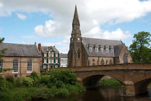
THE TOWN of Morpeth is situated on the Wansbeck, eighteen miles south by east of Alnwick, and 289 miles N.N.W. of London, in an agricultural district, which possesses a rich and cultivated soil, as also valuable timber, coal, and freestone. The Wansbeck flows eastward to the boundary of the municipal borough, which it skirts on the west, south, and east; and then flowing through a succession of narrow, but fertile vales, beautifully adorned with wood, falls into the sea at Camboise, about seven miles east of Morpeth. On the south side of the town the river is crossed by a small bridge, erected in 1831, from a design by Mr. Telford, immediately below a strong but narrow and steep old bridge of two arches, and connecting the castle, jail, etc., with the town. On the west it is crossed by a suspension footbridge, leading through the foot of Oldgate. A public promenade is situated a little to the east of the first bridge; it was arranged and laid out at the expense of the Earl of Carlisle and the Corporation. The town chiefly consists of two spacious and well built streets, with a small market-place. The market cross was erected in 1699, at the joint expense of the Hon. Philip Howard and Sir Henry Belasye, Knt. Near the market-place is a square clock tower containing an excellent peal of bells, which, in consequence of the church being at some distance from the town, are used for the ordinary parochial purposes. Morpeth holds no very prominent place in the history of the county, and during the Saxon and Danish period it was of small importance; but, after the Norman Conquest, it emerged from the rank of a village to that of an honour, and was styled "the barony of Morpeth.'' In 1215 the town was set on fire to prevent King John from resting there in his infamous expedition, and in 1689 it was again destroyed by an accidental conflagration, in which nearly all the buildings were consumed. Morpeth barony was anciently the property of the Merley family, but when this barony was created, or whether the above family possessed it before the Conquest, there is no satisfactory evidence.