Topics > Heritage Sites > Hadrian's Wall > Wall Mile 37 > Milecastle 37, Hadrian's Wall
Milecastle 37, Hadrian's Wall
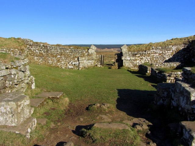
Milecastle 37 is location on Wall Mile 37 of Hadrian's Wall, west of Housesteads (fort). The milecastle is situated in a cleft of the Whinsill ridge, offering commanding views. The site includes remains of the north gate, with some arch stones still standing. There are surviving foundations providing outlines of internal buildings, including a barrack block.
There are thought to have been 80 milecastles on Hadrian’s Wall, located every Roman mile (1,000 paces) along the Wall, with two turrets (observation towers) spaced every third of a mile between them. The Milecastles were rectangular forts manned by small garrisons (probably 10-30 soldiers). The milecastles significance was much more than just their role in defending the Roman frontier. The milecastles had gateways in the north and south walls, often with towers on the north gate. They controlled passage through the Wall, supporting the checking of movement and levying taxes (customs) on goods and people. The milecastles also provided a visible symbol of Roman authority and imperial control. After Hadrian’s Wall was initially built (AD 122-8), larger forts (such as Housesteads) were added to the wall, providing bigger bases for fighting units, suggesting a shift in Roman strategy. In the 1930s a numbering system was devised, with the Milecastles numbered east to west.


from Flickr (flickr)
Wall Mile 37 - Milecastle 37 (Housesteads), Hadrian's Wall
Pinned by Simon Cotterill


from Flickr (flickr)
Hadrian's Wall, Hotbank Crags, heading towards Milecastle 37 and Housesteads Roman Fort
Pinned by Simon Cotterill

from Flickr (flickr)
Wall Mile 37 - Milecastle 37 (Housesteads), Hadrian's Wall
Pinned by Simon Cotterill
from Flickr (flickr)
Hadrian's Wall, Hotbank Crags, heading towards Milecastle 37 and Housesteads Roman Fort
Pinned by Simon Cotterill


