Topics > Northumberland > Civil Parishes in Northumberland > Alnwick Town Council area > Historic Buildings and Monuments in Alnwick
Historic Buildings and Monuments in Alnwick
Listed buildings and scheduled monuments in Alnwick from the National Heritage List for England[1]. There are a lot of them! Use the Search (below) if looking for a specific building / monument.
| Structure | List No. | Grade | Built~ | Note |
|---|---|---|---|---|
| Camp on Alnwick Moor | 1006474 | n/a | Scheduled monument | |
| Alnwick Castle - Grounds | 1001041 | I | C18th | Listed parks and gardens |
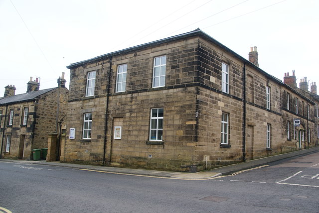
| No. 1 and 2 Pottergate and 5 Northumberland Street | 1178597 | II | ||
| Nos. 1 and 3, Bondgate Without | 1041527 | II | ||
| No. 1, Bailiffgate | 1371332 | II* | C18th | |
| No. 1, Bondgate Within | 1041522 | II | ||
| No. 1, Hotspur Street | 1371358 | II | ||
| No. 1, Percy Terrace | 1041453 | II | ||
| No. 1, South Street | 1371362 | II | ||
| Nos. 1-3, Croft Place | 1041502 | II | ||
| Nos. 1-3, Northumberland Street | 1041434 | II | ||
| Nos. 1-5, Narrowgate | 1041466 | II | ||
| Nos. 1-7, Prudhoe Street | 1041402 | II | ||
| Nos. 10 and 11, Percy Terrace | 1371376 | II | ||
| 10 Boundary Stones on Boundary with Alnwick Civil Parish | 1042024 | II | C18th | |
| No. 10, Bondgate Within | 1041515 | II | ||
| No. 10, Bondgate Without | 1041488 | II | ||
| No. 10, Market Place | 1157160 | II | ||
| No. 10, Market Street | 1371349 | II | ||
| No. 11, Market Street | 1302532 | II | ||
| No. 11, Narrowgate | 1371370 | II | ||
| Nos. 12 and 14, Bondgate Within | 1371337 | II | ||
| Nos. 12 and 14, Bondgate Without | 1371322 | II | ||
| Nos. 12 and 14, Green Batt | 1371355 | II | ||
| No. 12, Market Street | 1157250 | II | ||
| Nos. 13 and 15, Bailiffgate | 1041511 | II | ||
| Nos. 13 and 15, Market Street | 1371346 | II | ||
| No. 13, Canongate | 1156264 | II | ||
| No. 13, Percy Terrace | 1178546 | II | ||
| Nos. 13-17, Bondgate Without | 1041485 | II | ||
| Nos. 13-17, Howick Street | 1041449 | II | ||
| Nos. 14 and 16, Saint Michael's Lane | 1178616 | II | ||
| No. 14, Bailiffgate | 1041506 | II | ||
| No. 14, Fenkle Street | 1041469 | II | ||
| No. 14, Walkergate | 1178706 | II | ||
| Nos. 15-19, Fenkle Street | 1041473 | II | ||
| Nos. 16 and 18, Fenkle Street | 1041470 | II | ||
| No. 16, Bondgate Within | 1156031 | II | ||
| No. 16, Narrowgate | 1371372 | II | ||
| Nos. 16-20, Bailiffgate | 1371331 | II | ||
| Nos. 17 and 19, Bailiffgate | 1041512 | II | ||
| Nos. 17 and 19, Market Street | 1157167 | II | ||
| No. 18, Narrowgate | 1041428 | II | ||
| Nos. 19 and 21, Howick Street | 1371343 | II | ||
| No. 19, Clayport Street | 1041495 | II | ||
| Nos. 19-23, Green Batt | 1302641 | II | ||
| Nos. 1a and 1b, Bailiffgate | 1041509 | II | ||
| No. 1c, Bailiffgate | 1371333 | II | ||
| Nos. 2 and 3, Percy Street | 1041436 | II | ||
| Nos. 2 and 4, Clayport Street | 1156387 | II | ||
| Nos. 2 and 4, Lisburn Street | 1041451 | II | ||
| 2 Boundary Stones on Boundary with Alnwick Civil Parish | 1054068 | II | C18th | |
| No. 2, Bailiffgate | 1041547 | II* | 1797 | |
| No. 2, Bondgate Within | 1371336 | II | ||
| No. 2, Hotspur Street | 1302606 | II | ||
| No. 2, Percy Terrace | 1178534 | II | ||
| Nos. 2-6, Chapel Lane | 1041493 | II | ||
| Nos. 20 and 22, Green Batt | 1041480 | II | ||
| Nos. 20 and 22, Narrowgate | 1371373 | II | ||
| No. 20, Bondgate Without | 1041489 | II | ||
| No. 20, Fenkle Street | 1371353 | II | ||
| No. 21, Bailiffgate | 1371335 | II | ||
| Nos. 22 and 24, Saint Michael's Lane | 1041404 | II | ||
| No. 22, Bondgate Without | 1371323 | II | ||
| No. 22, Fenkle Street | 1041471 | II | ||
| Nos. 22-26, Bailiffgate | 1041507 | II | ||
| No. 23, Clayport Street | 1302926 | II | ||
| Nos. 24 and 26, Walkergate | 1371364 | II | ||
| No. 24, Fenkle Street | 1371369 | II | ||
| No. 24, Howick Street (Upper) | 1041447 | II | ||
| Nos. 25 and 25a, Clayport Street | 1041496 | II | ||
| No. 25, Green Batt | 1178480 | II | ||
| Nos. 26 and 28, Fenkle Street | 1041424 | II | ||
| No. 27, Fenkle Street | 1156885 | II* | C19th | |
| Nos. 28 and 30, Bailiffgate | 1041508 | II | ||
| No. 28, Narrowgate | 1041430 | II | ||
| Nos. 3 and 5, Hotspur Street | 1371340 | II | ||
| No. 3, Fenkle Street | 1371354 | II | ||
| No. 3, South Street | 1178628 | II | ||
| No. 3, Walkergate | 1041412 | II | ||
| No. 30, Narrowgate | 1041431 | II | ||
| No. 31, Fenkle Street | 1041475 | II | ||
| Nos. 33 and 35, Market Street | 1041463 | II | ||
| No. 34, Green Batt | 1156934 | II | ||
| Nos. 36 and 38, Green Batt | 1156959 | II | ||
| No. 36, Narrowgate | 1041433 | II | ||
| No. 37, Fenkle Street | 1041476 | II | ||
| No. 37, Market Street | 1371348 | II | ||
| No. 39, Bondgate Within | 1156071 | II | ||
| No. 39, Fenkle Street | 1156891 | II | ||
| Nos. 4 and 5, Percy Street | 1041437 | II* | C19th | |
| Nos. 4 and 5, Percy Terrace | 1041440 | II | ||
| Nos. 4 and 6, Bondgate Within | 1303079 | II | ||
| Nos. 4 and 6, Market Street | 1157246 | II | ||
| No. 4, Bailiffgate | 1371311 | II | ||
| No. 4, Grey Place | 1371357 | II | ||
| No. 4, South Street | 1371363 | II | ||
| Nos. 41 and 43, Bondgate Within | 1041524 | II | ||
| Nos. 45 and 47, Bondgate Without | 1371320 | II | ||
| No. 46, Bondgate Within | 1041518 | II | ||
| No. 47, Bondgate Within | 1156078 | II | ||
| No. 48, Bondgate Within | 1303056 | II | ||
| Nos. 49 and 51, Bondgate Within | 1041525 | II | ||
| Nos. 5 and 7, Bailiffgate | 1041510 | II | ||
| Nos. 5 and 7, Bondgate Within | 1156060 | II | ||
| No. 5, Walkergate | 1041413 | II | ||
| Nos. 5-11, Howick Street | 1371342 | II | ||
| Nos. 50 and 52, Bondgate Within | 1041519 | II | ||
| No. 52, Bondgate Without | 1041490 | II | ||
| No. 54, Bondgate Within | 1041520 | II | ||
| No. 56, Bondgate Within | 1156054 | II | ||
| Nos. 58 and 60 Bondgate Within | 1041521 | II | ||
| Nos. 6 and 7, Percy Street | 1178496 | II | ||
| Nos. 6 and 8, Bailiffgate | 1041548 | II | ||
| No. 6, Fenkle Street | 1371352 | II | ||
| No. 6, Lisburn Street | 1041452 | II | ||
| Nos. 67 and 67a, Bondgate Within | 1041526 | II | ||
| Nos. 69-75, Bondgate Within | 1302987 | II | ||
| Nos. 7 and 9, Clayport Street | 1156342 | II | ||
| Nos. 7 and 9, Market Street | 1041461 | II | ||
| No. 7, Walkergate | 1041414 | II | ||
| Nos. 7-13, Lisburn Street | 1302566 | II | ||
| Nos. 8 and 9, Percy Street | 1371374 | II | ||
| Nos. 8 and 9, Percy Terrace | 1302392 | II | ||
| No. 8, Bondgate Within | 1041514 | II | ||
| No. 8, Bondgate Without | 1371321 | II | ||
| No. 8, Market Street | 1041465 | II | ||
| Nos. 8-10, Prudhoe Street | 1302349 | II | ||
| Nos. 8-12, Lisburn Street | 1302563 | II | ||
| Nos. 8-14, Narrowgate | 1041427 | II | ||
| Nos. 8-16, Howick Street | 1371341 | II | ||
| Nos. 9 and 11, Bailiffgate | 1371334 | II | ||
| Nos. 9, 10, and 10A, Paikes Lane | 1041435 | II | ||
| Alnbank House | 1041542 | II | ||
| Alndyke | 1041544 | II | ||
| Alnwick Baptist Church | 1041454 | II | 1830s | Lisburn Street |
| Bali Hai | 1371375 | II | ||
| Barndale Cottage | 1041450 | II | ||
| Barndale House | 1371344 | II | ||
| Black Swan Public House | 1041429 | II | ||
| Blakelaw Cottage | 1156008 | II | ||
| Bondgate Hall | 1302989 | II* | c.1810 | Bondgate Without |
| Boundary Stone on Boundary with Alnwick Civil Parish 320 Metres West of Summit Cottages | 1054055 | II | ||
| Boundary Stone on Boundary with Alnwick Civil Parish 360 Metres South South East of Freemanshill | 1371087 | II | ||
| Boundary Stone on Boundary with Alnwick Civil Parish 480 Metres North of the Union Stone | 1371079 | II | ||
| Burgage walls between No 5 and Cornmarket Market Street and between No 5 and the Terrace on east sid | 1371351 | II | ||
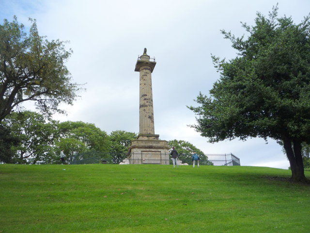
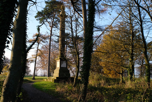
| Camphill Column | 1041409 | II* | 1814 | Swansfield Park |
| Camphill Cottage | 1178645 | II | ||
| Canongate Bridge | 1041491 | I | 1821 | Bridge over the River Aln |
| Church of St James (Presbyterian) | 1178598 | II | 1894 | Pottergate. By Hicks & Charlewood |
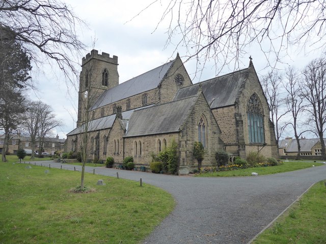
| Church of St Michael | 1041546 | I | C15th | Some reminants of C12th church |
| Church of St Paul | 1041438 | II* | 1846 | RC church by Anthony Salvin |
| Churchyard Gates of the Church of St Mary and St Michael | 1371310 | II | ||
| Clive Cottage | 1041500 | II | ||
| Clive House | 1156422 | II | ||
| Clive Terrace (1-8) | 1156404 | II | ||
| Coates the Printers | 1372335 | II | ||
| Column Cottage | 1371300 | II | ||
| Corner Cafe | 1041456 | II | ||
| Council Office | 1302312 | II | ||
| County House | 1157179 | II | ||
| Crown Public House | 1041462 | II | ||
| Doric House | 1178507 | II | ||
| Dorothy Foster Court | 1041426 | II | ||
| Dorothy Foster's House | 1371371 | II* | C18th | No. 35, Narrowgate |
| Dukes Cottages | 1371359 | II | ||
| Easycare Centre | 1041459 | II | ||
| Eyecatcher in Swansfield Park Wall West Side Near 'Eastview' | 1041410 | II | ||
| Forest Lodge and Stockingate | 1041403 | II | ||
| Former Correction House Yard at Rear of No 34 | 1371356 | II | ||
| Former Malthouse to North of No 20 | 1041505 | II | ||
| Former Pant | 1041503 | II | ||
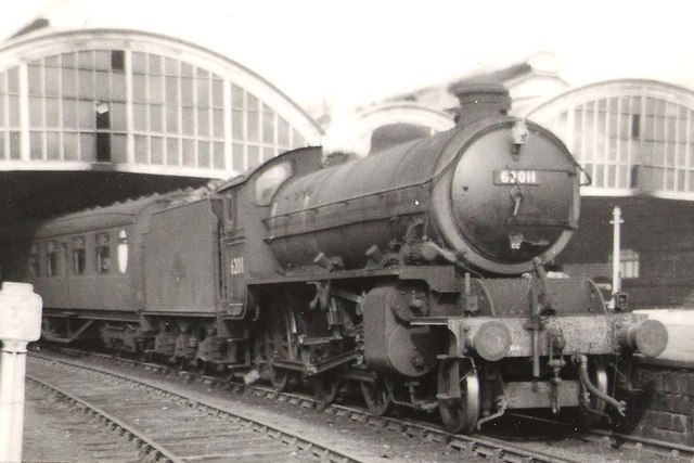
| Former Railway Terminus | 1041411 | II | 1887 | Former station, now Barter Books |
| Former Sion Meeting House | 1371361 | II | ||
| Former Workhouse and Keeper's House | 1041482 | II | ||
| Fountain in Garden to South of Linhope House | 1041408 | II | ||
| Freelands | 1041543 | II | ||
| Freeman's Hill Farmhouse | 1041545 | II | C18th | |
| Garden Wall on North and East Sides of Green Batt House and Gate Piers | 1302646 | II | ||
| Garden Walls and Gates to Linhope House Closing East End of South Street | 1178633 | II | ||
| Gardeners Cottage Near West Entrance to Castle Kitchen Garden | 1302933 | II | ||
| Gate Piers and Gates to the Parish Church of St Paul | 1041439 | II | ||
| Gates, Railings and Steps to Sheraton House | 1371326 | II | ||
| Gateway (To Castle Grounds) Opposite Lodge to Allerburn | 1156488 | II | ||
| General Lambert's House | 1041425 | II* | C19th | Nos. 31 & 33, Narrowgate |
| Glebelands Lodge | 1041479 | II | ||
| Green Batt House | 1041478 | II | ||
| Grosvenor Terrace (1 and 2) | 1041498 | II | ||
| Grosvenor Terrace (3, 4 and 5) | 1041499 | II | ||
| Grove House | 1041446 | II | ||
| Happy Haven | 1041406 | II | ||
| Herds House Farmhouse | 1371309 | II | C18th | Alnwick Moor |
| High Pant (Clayport Bank) | 1041501 | II | ||
| Hope House Kincraig | 1371378 | II | ||
| Hope House | 1156979 | II | ||
| Hope Lodge | 1178594 | II | ||
| Houses Occupied by Mr Wilkinson and Mr Sparks | 1371328 | II | ||
| Howick House | 1041448 | II | ||
| Kitchen Garden Walls | 1371325 | II | ||
| Linhope House | 1041407 | II | ||
| Lloyds Bank | 1041517 | II | ||
| Loan End | 1041441 | II | ||
| Lodge and Gates at Alnwick Cemetery | 1372336 | II | ||
| Lovaine Place | 1041443 | II | ||
| Lovaine Place | 1371377 | II | ||
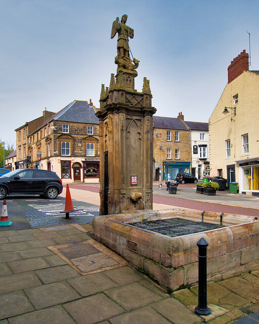
| Market Cross | 1157108 | II | ||
| Methodist Church | 1302938 | II | ||
| N and B Pringles | 1371345 | II | ||
| No 20 and Mill at Rear | 1041504 | II | ||
| North Chapel at Alnwick Cenetery | 1237596 | II | ||
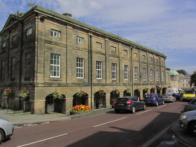
| Northumberland Hall (Assembly Rooms) | 1041460 | I | 1826 | Now incorporates the Tourist Information Centre |
| Number 2, the Tanners Arms and Numbers 4 and 6 | 1041483 | II | ||
| Number 39 Including the Hat Shop | 1302503 | II | ||
| Outhouse to South East of St Thomas's Farmhouse | 1371327 | II | ||
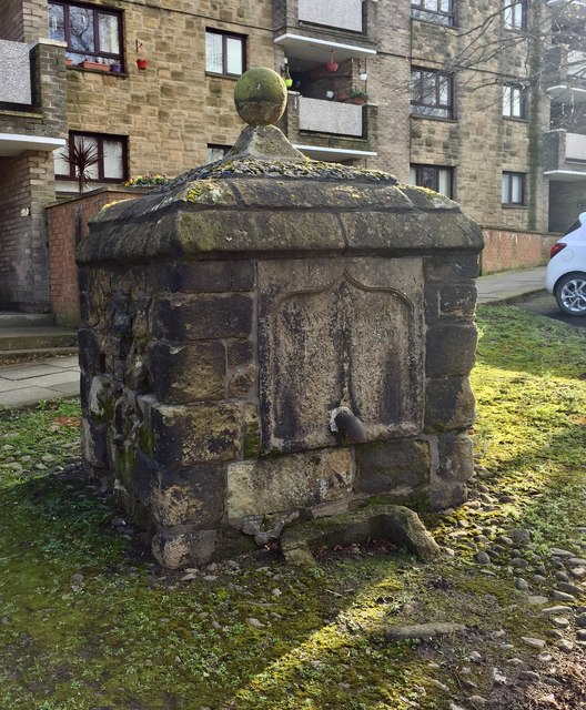
| Pant | 1041445 | II | ||
| Pant Outside Westgate House | 1041497 | II | 1755 | Clayport Street |
| Percy House | 1041442 | II | ||
| Percy Tenantry Column | 1041405 | I | 1816 | |
| Percy Villa | 1178569 | II | ||
| Piers and Railings in Front of the Roman Catholic Church of St Mary | 1371330 | II | ||
| Pottergate Tower | 1041444 | II* | 1768 | |
| Queens Head Hotel | 1371347 | II | ||
| Rear Elevation of Number 6 Fenkle Street | 1041457 | II | ||
| Retaining Wall to Churchyard | 1371324 | II | ||
| Retaining Walls | 1178700 | II | ||
| Robertsons Pant | 1156086 | II | 1890 | Bondgate Within |
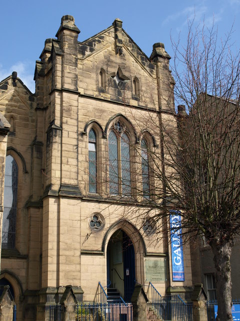
| Roman Catholic Church of St Mary | 1155951 | II | 1856 | Now Bailiffgate Museum |
| Savings Bank | 1178611 | II | ||
| Sheraton House | 1156308 | II | ||
| South Chapel at Alnwick Cemetery | 1052194 | II | ||
| South Road | 1178621 | II | ||
| St Marys Chantry (Ruins) | 1041415 | II* | c.1448 | |
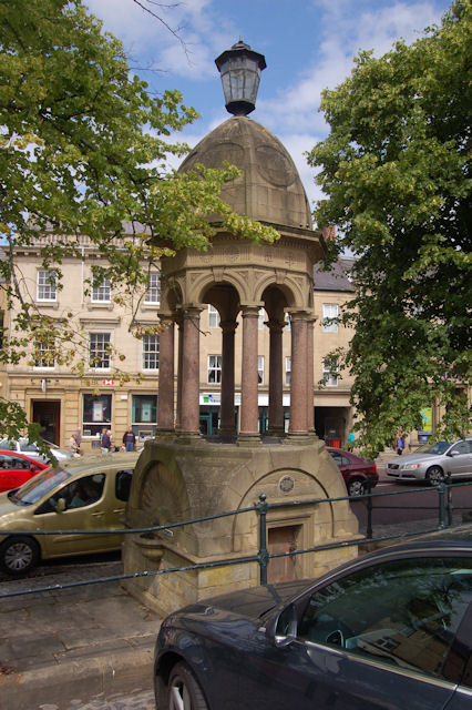
| St Michael's Pant | 1041464 | II* | 1765 | Market Street |
| St Thomas's Farmhouse | 1156451 | II | ||
| Stables South West of Bondgate Hall | 1041528 | II | ||
| Steele's Gift Shop | 1157155 | II | ||
| Stonewall Lane South Wall | 1041474 | II | ||
| Terrace of 4 Houses on West Side to North of Wall an Drear of No 2 Green Batt | 1041468 | II | ||
| Terrace on East Side and at Rear of No 39 Market Place | 1371350 | II | ||
| Alnwick Castle, Stable Court and Covered Riding School Including West Wall of Riding School | 1371308 | I | C12th | |
| The Co-Op | 1041458 | II | ||
| Corn Exchange | 1371338 | II | ||
| Cross House | 1041467 | II | ||
| Dukes School | 1391457 | II | ||
| Fleece Inn | 1041486 | II | ||
| The George Public House | 1371339 | II | ||
| The Globe Inn | 1041523 | II | ||
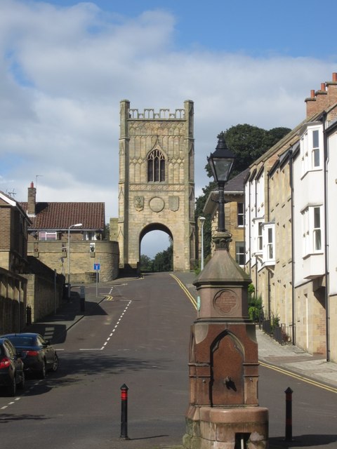
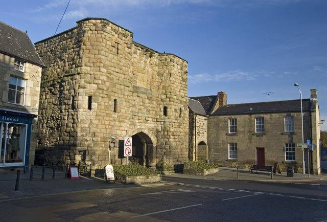
| Hotspur Gateway or Bondgate Tower | 1041513 | I | C15th | Also a Scheduled monument 1006597 |
| The Kennels | 1302866 | II | ||
| The Kiln | 1178449 | II | ||
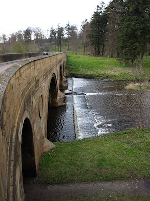
| The Lion Bridge | 1178596 | I | 1775 | Bridge over the River Aln |
| Market Tavern | 1041472 | II | ||
| Nag's Head Public Head | 1156866 | II | ||
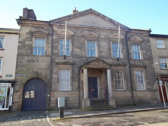
| The Old Post Office | 1041494 | II* | C19th | Clayport Street |
| The Pinfold | 1041477 | II | ||
| Victoria Infants School | 1041455 | II | ||
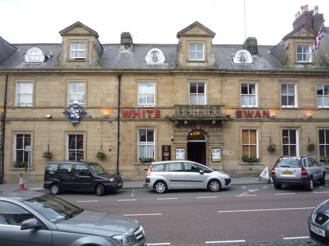
| White Swan Hotel | 1041516 | II | C19th | Features fixtures from the SS Olymic (sister ship of the Titanic) |
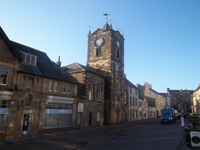
| Town Hall | 1157140 | I | 1731 | |
| Wall at Rear of Number 22 | 1041481 | II | ||
| Wall Between Number 14 and Former Workhouse in Green Batt | 1041484 | II | ||
| Wall to South of Methodist Church | 1392479 | II | ||
| Walls Enclosing Yard at Rear of Number 8 to North and East | 1156024 | II | ||
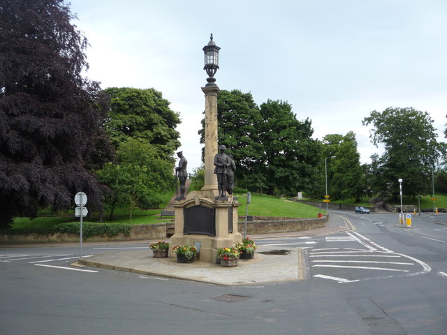
| War Memorial | 1041487 | II | 1922 | Denwick Lane / Bondgate Without |
| Water Tower on West Side of Kitchen Garden | 1041492 | II | ||
| West Wing of the Convent of the Sisters of Mercy | 1371312 | II | ||
| William the Lion Commemorative Stone and Wall to Each Side | 1371360 | II | ||
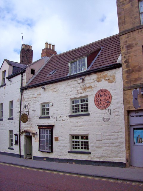
| Ye Olde Cross Public House 'Dirty Bottles' | 1041432 | II | C17th | Narrowgate |
| Alnwick Conservation Area | - | n/a | Conservation Area |
Primary source: the National Heritage List for England - NHLE is the register of nationally protected historic buildings and sites in England, including listed buildings, scheduled monuments, protected wrecks, registered parks and gardens, and battlefields. The list is maintained by Historic England. Check NHLE for updates and new entries. Secondary sources: British Listed Buildings and Keys to the Past.
Co-Curate Page
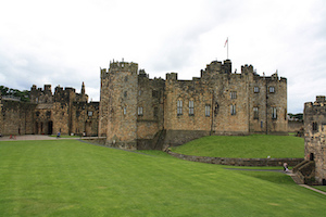
Alnwick Castle
- Overview History Map Street View Alnwick Castle is the seat of the Duke of Northumberland, built by the River Aln in Alnwick following the Norman conquest. The castle is open …
Co-Curate Page
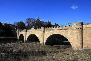
The Lion Bridge
- Overview Map Street View The Lion Bridge over the River Aln at Alnwick was built in 1775 by John Adam.[1] The stone bridge has 4 arches and in the centre of …
Co-Curate Page
Pottergate Tower
- Overview Map Street View Pottergate Tower in Alnwick was formerly part of the town's medieval defences. The tower was rebuilt in 1768 to a design by Mr Henry Bell. It …
Co-Curate Page
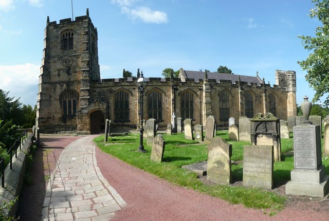
Church of St Michael
- Overview About St Michael's Church Map Street View St Michael’s Church is located on Bailiffgate in Alnwick, Northumberland. The current building dates from the 15th century, but includes some remnants of …
Co-Curate Page
Percy Tenantry Column
- Overview Map Street View When agricultural prices fell after the Napoleonic Wars, Hugh, the 2nd Duke of Northumberland, reduced the rents of his tenants by a quarter to alleviate their …
Co-Curate Page
War Memorial
- Overview Map Street View The war memorial in Alnwick is located at the junction of Denwick Lane and Bondgate Without, near the Percy Tenantry Column. The memorial was unveiled by …
Co-Curate Page
Old Town Hall
- Overview Map Street View "This Town House of the Burgesses of Alnwick rebuilt in the year of Our Lord 1731 by Edward Grey, Richard Grieve, William Forster, Robert Claxton: Chamberlains" …
Co-Curate Page
Northumberland Hall
- Overview Map Street View Incorporates the Tourist Information Centre for Alnwick.
Co-Curate Page
Former Railway Station, Alnwick - Barter Books
- Overview About Alnwick Station Map Street View Alnwick Railway Station on Wagon Way Road in Alnwick was opened on the 5th September, 1887. It was built as part of the …
Co-Curate Page
The Dirty Bottles
- Overview Map Street View The Dirty Bottles is a freehouse pub on Narrowgate in Alnwick. The right-hand part of the building has 2 windows and dates from the 17th century; …
Co-Curate Page
Church of St Paul, Alnwick
- Overview Map Street View St Paul's RC Church on Percy Street in Alnwick was built in 1846 by Anthony Salvin. The church is a Grade II* listed building on the …
Co-Curate Page
Bailiffgate Museum, Alnwick
- Overview Map Street View Bailiffgate Museum and Gallery, a community-run museum dedicated to the history of Alnwick and its surrounding area. The museum is located in the formner Roman Catholic Church …
Co-Curate Page
The Old Post Office, Alnwick
- Overview Map Street View The Old Post Office building is located on Clayport Street in Alnwick. It was built in the early 19th century and is Grade II* listed on …
Co-Curate Page
Alnwick Baptist Church
- Overview Map Street View Alnwick Baptist Church is located on ther corner of Lisburn Street and Upper Howick Street in Alnwick. It was originally built in the 1830s as a …

Co-Curate Page
St James' URC Church, Alnwick
- Overview Map Street View St James United Reformed Church is located on Pottergate in Alnwick. The church was built in 1894, designed by Hicks and Charlewood. The church is a …

Co-Curate Page
Freeman's Hill, Alnwick
- Overview Map Street View Freeman's Hill Farm is located about 3½ miles south-west of the town of Alnwick. The farm was built and enclosed from Alnwick Moor common in 1771. …

Co-Curate Page
Herds House, Alnwick
- Overview Map Street View Herds House is a farm was enclosed and built on Alnwick Common (Aydon Forest) in 1705. The present building probably dates from the later 18th century. …

Co-Curate Page
Alnwick Castle
- Overview History Map Street View Alnwick Castle is the seat of the Duke of Northumberland, built by the River Aln in Alnwick following the Norman conquest. The castle is open …
Co-Curate Page
The Lion Bridge
- Overview Map Street View The Lion Bridge over the River Aln at Alnwick was built in 1775 by John Adam.[1] The stone bridge has 4 arches and in the centre of …
Co-Curate Page
Pottergate Tower
- Overview Map Street View Pottergate Tower in Alnwick was formerly part of the town's medieval defences. The tower was rebuilt in 1768 to a design by Mr Henry Bell. It …
Co-Curate Page
Church of St Michael
- Overview About St Michael's Church Map Street View St Michael’s Church is located on Bailiffgate in Alnwick, Northumberland. The current building dates from the 15th century, but includes some remnants of …
Co-Curate Page
Percy Tenantry Column
- Overview Map Street View When agricultural prices fell after the Napoleonic Wars, Hugh, the 2nd Duke of Northumberland, reduced the rents of his tenants by a quarter to alleviate their …
Co-Curate Page
War Memorial
- Overview Map Street View The war memorial in Alnwick is located at the junction of Denwick Lane and Bondgate Without, near the Percy Tenantry Column. The memorial was unveiled by …
Co-Curate Page
Old Town Hall
- Overview Map Street View "This Town House of the Burgesses of Alnwick rebuilt in the year of Our Lord 1731 by Edward Grey, Richard Grieve, William Forster, Robert Claxton: Chamberlains" …
Co-Curate Page
Northumberland Hall
- Overview Map Street View Incorporates the Tourist Information Centre for Alnwick.
Co-Curate Page
Former Railway Station, Alnwick - Barter Books
- Overview About Alnwick Station Map Street View Alnwick Railway Station on Wagon Way Road in Alnwick was opened on the 5th September, 1887. It was built as part of the …
Co-Curate Page
The Dirty Bottles
- Overview Map Street View The Dirty Bottles is a freehouse pub on Narrowgate in Alnwick. The right-hand part of the building has 2 windows and dates from the 17th century; …
Co-Curate Page
Church of St Paul, Alnwick
- Overview Map Street View St Paul's RC Church on Percy Street in Alnwick was built in 1846 by Anthony Salvin. The church is a Grade II* listed building on the …
Co-Curate Page
Bailiffgate Museum, Alnwick
- Overview Map Street View Bailiffgate Museum and Gallery, a community-run museum dedicated to the history of Alnwick and its surrounding area. The museum is located in the formner Roman Catholic Church …
Co-Curate Page
The Old Post Office, Alnwick
- Overview Map Street View The Old Post Office building is located on Clayport Street in Alnwick. It was built in the early 19th century and is Grade II* listed on …
Co-Curate Page
Alnwick Baptist Church
- Overview Map Street View Alnwick Baptist Church is located on ther corner of Lisburn Street and Upper Howick Street in Alnwick. It was originally built in the 1830s as a …
Co-Curate Page
St James' URC Church, Alnwick
- Overview Map Street View St James United Reformed Church is located on Pottergate in Alnwick. The church was built in 1894, designed by Hicks and Charlewood. The church is a …
Co-Curate Page
Freeman's Hill, Alnwick
- Overview Map Street View Freeman's Hill Farm is located about 3½ miles south-west of the town of Alnwick. The farm was built and enclosed from Alnwick Moor common in 1771. …


