Topics > Northumberland > Civil Parishes in Northumberland > Cartington Civil Parish (abolished 2021) > Historic Buildings and Monuments in the former Cartington Civil Parish
Historic Buildings and Monuments in the former Cartington Civil Parish
Listed buildings and scheduled monuments in the former Cartington Civil Parish, Northumberland, from the National Heritage List for England[1]. Use the Search (below) if looking for a specific building / monument.
Cartington Civil Parish was abolished in 2021 and was absorbed into Thropton and Rothbury Civil Parishes.
| Structure | List No. | Grade | Built~ | Notes |
|---|---|---|---|---|
| Boundary Stone 250 Metres West of Sheepfold by Forster's Shaw Sike | 1153330 | II | ||
| Boundary Stone 350 Metres East of Sheepfold by Forster's Shaw Sike | 1042040 | II | ||
| Boundary Stone on North of Debdon Track 210 Metres from Road | 1042069 | II | ||
| Boundary Stone on North of Debdon Track 80 Metres from Road | 1042068 | II | ||
| Boundary Stones to South of Hard Heugh Crag | 1042038 | II | ||
| Burnfoot Power House, 70 Metres North of Burnfoot Lodge | 1042071 | II* | ||
| Cragside (house) | 1042076 | I | 1864 | Now a National Trust property. |
| Cragside Visitor Centre | 1042034 | II | 1864 | Former stables |
| Debdon Sawmill and Attached Wall to South West | 1371031 | II* | ||
| Hydraulic Silo Building 70 Metres East of Cragend Farmhouse | 1153196 | II* | ||
| Marker Stone 90 Metres South of Bridge over Debdon Burn | 1042067 | II | ||
| Pill Box at NU 067005 | 1372337 | II | ||
| Row of 3 Boundary Stones South of Debdon Whitefield | 1042036 | II | ||
| Row of 5 Boundary Stones | 1042074 | II | ||
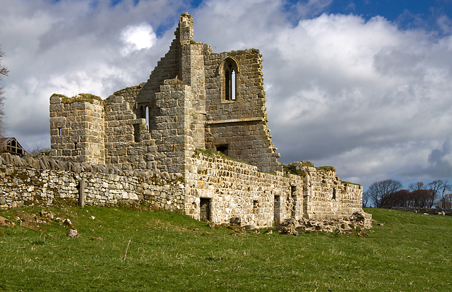
| Ruins of Cartington Castle | 1042073 | I | C15th | |
| Stone Bridge Across the Debdon Burn 220 Metres South West of Cragside | 1371052 | II | C19th | |
| Stone on North Side of Old Road, 30 Meres North East of Present Bridge over Whitton Burn | 1042070 | II | ||
| Tumbleton Boat House | 1371053 | II | C19th | |
| Tumbleton Ram House on West of Debdon Burn at Foot of Tumbelton Dam | 1042035 | II | 1866 | Pumphouse on the Cragside estate |
| Whittle Farmhouse | 1371057 | II | ||
| Cragside (grounds) | 1001046 | I | C19th | Listed park and garden. Parts in Rothbury, Cartington, and Ford CPs. |
| Cairn 1110m north-east of Cartington Castle | 1008690 | n/a | Scheduled Monument | |
| Cairn 1150m north-east of Cartington Castle | 1008689 | n/a | Scheduled Monument | |
| Cairn 1250m north-east of Cartington Castle | 1008691 | n/a | Scheduled Monument | |
| Cartington Castle at Cartington Farm | 1011611 | n/a | Scheduled Monument | |
| Camp 1/2 mile (800m) SE of Wagtail Farm | 1002909 | n/a | Scheduled Monument | |
| Cairn 600m west-south-west of Debdon Farm | 1008696 | n/a | Scheduled Monument | |
| Cairnfield on Whitefield Edge, 900m south-west of Debdon Whitefield | 1008879 | n/a | Scheduled Monument | |
| Cairn 610m east of Glitteringstone | 1011631 | n/a | Scheduled Monument | |
| Cairn 500m west of Debdon Farm | 1011632 | n/a | Scheduled Monument | |
| Unenclosed stone hut circle settlement, cairn fields and a rectangular enclosure 1km south-west of Debdon Whitefield | 1011633 | n/a | Scheduled Monument | |
| Cairnfield, standing stone and cup marked rock on Debdon Moor 500m south-west of Primrose Cottage | 1011634 | n/a | Scheduled Monument | |
| Cupmarked stone, 690m south-west of Wagtail Farm | 1011288 | n/a | Scheduled Monument | |
| Cup and ring marked rock, 940m south-west of Wagtail Farm | 1011289 | n/a | Scheduled Monument |
Primary source: the National Heritage List for England - NHLE is the register of nationally protected historic buildings and sites in England, including listed buildings, scheduled monuments, protected wrecks, registered parks and gardens, and battlefields. The list is maintained by Historic England. Check NHLE for updates and new entries.
Secondary sources: British Listed Buildings and Keys to the Past.
Co-Curate Page
Cartington Castle
- Overview About Cartington Castle Map The castle's location is near Spout Burn, for its supply of fesh water, and has a commanding view of the Debdon pass over the Rothbury …


