Topics > County Durham > Wolsingham > Wolsingham Parish, 1848
Wolsingham Parish, 1848
Extract from: A Topographical Dictionary of England comprising the several counties, cities, boroughs, corporate and market towns, parishes, and townships..... 7th Edition, by Samuel Lewis, London, 1848.
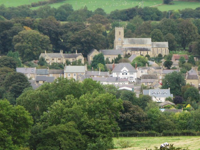
WOLSINGHAM (St. Matthew), a market-town and parish, in the union of Weardale, N. W. division of Darlington ward, S. division of the county of Durham, 10 miles (W.N.W.) from Bishop-Auckland, 16 (W.S.W.) from Durham, and 259 (N.N.W.) from London; containing 2,086 inhabitants. This town, which is irregularly built, is pleasantly situated in the narrow, but exceedingly picturesque, vale of the Wear, on the north bank of the river, and near the point where it receives the united streams of the Thornhope and Wascrow rivulets. There are manufactures of linen, woollencloth, edge-tools, and implements of husbandry, in which, and in the neighbouring coal, lead, and lime works, a great portion of the population is employed. Workmen are also engaged in mining for ironstone, which is supposed to be in considerable abundance; and should the result of their operations be satisfactory, it is in contemplation to erect works in the immediate vicinity of the town. An act was passed in 1845 for making a railway called the Wear-Valley railway: the line runs from the Bishop-Auckland and Weardale railway, past Wolsingham, to Frosterley, and has a branch to Bishopley Crag; the total length being 11¾ miles. The market and fairs are held by grant from the Bishop of Durham; the former is on Tuesday, and the latter on May 12th and October 2nd, for cattle and all sorts of merchandise. Petty-sessions are held every Tuesday; and a court leet and baron, under the bishop as lord of the manor, takes place twice a year, at which debts under 40s. are recoverable. The powers of the county debt-court of Wolsingham, established in 1847, extend over part of the registration-district of Weardale. In 1824, a town-hall, of stone, was erected in the centre of the market-place; it contains a spacious newsroom. The parish is divided into the four constableries of Wolsingham, WolsinghamPark, and East and South Wolsingham; and comprises 24,157a. 2r., of which 4000 acres are arable, 12,000 meadow and pasture, 1000 woodland, 6786 common uninclosed, and 371 road and waste. The extensive moors in the neighbourhood abound in game.
The living is a rectory, valued in the king's books at £31. 13. 4., and in the gift of the Bishop: the tithes have been commuted for £900, and the glebe comprises 12 acres, with a house. The church, situated on rising ground to the north-west of the town, is an ancient and neat plain edifice, with a low tower, and has a font of Weardale marble, beautifully variegated with petrifactions of shells, &c. There are places of worship for Baptists, Primitive Methodists, and Wesleyans. The grammar school, founded in 1613, with a residence for the master, was rebuilt in 1786, by subscription (Bishop Egerton, and Dr. Sharp, archdeacon of Northumberland, a trustee of Lord Crewe's charity, being the principal contributors), upon a piece of waste granted by the bishop and the landowners of the parish, by whom it was endowed with 16 acres of land. About 7½ acres were added on the inclosure of the moor, and bequests have been made to the school, of £30 by the Rev. William Nowell, in 1782; £100 by Jonathan Wooler, in 1789; and £100 by George Wooler, in 1826. The poor of Wolsingham are periodically relieved by the interest of various benefactions, amongst which are bequests of £200 each, left by the Rev. W. Nowell and the Rev. Robert Gordon, and an annual sum of £18 from land purchased with the bequests of Messrs. Markindale, Aisley, and others. Contiguous to a field called Chapel Walls, are the remains of an extensive building surrounded by a moat, supposed to have been the manor-house of the Bishop of Durham. Henry Pudsey, nephew to Bishop Pudsey, contemplated the erection of a religious institution at Baxtonford, in Wolsingham-Park, the intended site for which is marked by a quantity of stone collected for the purpose. There are several chalybeate springs; and about two miles east of Wolsingham, on the Bradley estate, is a sulphureous spring.

from https://openlibrary.org/books…
A topographical dictionary of England, Samuel Lewis, 7th Ed., 1848
- A topographical dictionary of England
comprising the several counties, cities, boroughs, corporate and market towns, parishes, and townships, and the islands of Guernsey, Jersey, and Man, with historical and statistical …
Added by
Simon Cotterill