Topics > Civil Parishes in Cumbria > Historic Buildings and Monuments in Preston Richard
Historic Buildings and Monuments in Preston Richard
Listed buildings and scheduled monuments in Preston Richard Civil Parish, Cumbria, from the National Heritage List for England[1]. Use the Search (below) if looking for a specific building / monument.
| Structure | List No. | Grade | Built~ | Note |
|---|---|---|---|---|
| Aqueduct carrying Kendal/Lancaster Canal over Peasey Beck NGR 5347 8338 | 1327019 | II | c.1818 | Crooklands |
| Birkrigg Park Farmhouse | 1086528 | II | 1742 | Birkrigg Park |
| Boundary Stone Approximately 30 Yards North West of Storth End Farmhouse Near Summerlands | 1086524 | II | C19th | |
| Crooklands Bridge over Kendal Lancaster Canal NGR 5339 8358 | 1086527 | II | c.1818 | Crooklands |
| Field End Bridge over Kendal Lancaster Canal NGR 5259 8499 | 1336110 | II | c.1818 | |
| High Banks Farmhouse Attached Barn to Left and Front Garden Walls and Railings | 1137398 | II | C18th | Milton |
| Mattinsons Bridge over Kendal/Lancaster Canal NGR 5248 8395 | 1336088 | II | c.1818 | |
| Milestone 100 Yards South of South Lodge | 1086525 | II | 1826 | A65 |
| Milestone Approximately 200 Yards South West of Lane Farm | 1086526 | II | C19th | B6385, Crooklands |
| Milestone Approximately 400 Yards North of Mattinsons Bridge on the Kendal/Lancaster Canal Ngr 524/8 | 1086523 | II | c.1818 | |
| Milton Mill House and Attached Mill | 1086529 | II | C18th | Milton |
| Old Hall Bridge over Kendal/Lancaster Canal Near Crooklands NGR 5289 8382 | 1336108 | II | c.1818 | |
| Privy to Left of High Banks Farmhouse | 1336112 | II | C19th | |
| Storth End Farmhouse Near Summerlands | 1336109 | II | C17th | |
| Low Gatebeck gunpowder works, 540m south west of Gatebeck Farm | 1018135 | n/a | C19th | Scheduled Monument |
Primary source: the National Heritage List for England - NHLE is the register of nationally protected historic buildings and sites in England, including listed buildings, scheduled monuments, protected wrecks, registered parks and gardens, and battlefields. The list is maintained by Historic England. Check NHLE for updates and new entries. Secondary sources: British Listed Buildings.
Co-Curate Page
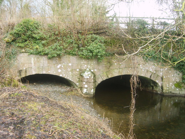
Crooklands Aqueduct, Lancaster Canal
- Overview Map Street View At the south of Crooklands, by Milton Lane, is an aqueduct carrying the Lancaster Canal over Peasey Beck. The aqueduct, with two shallow elliptical arches, was …
Co-Curate Page
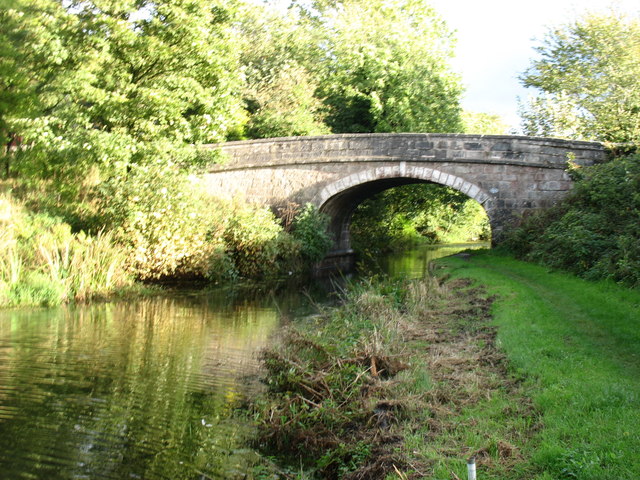
Crooklands Bridge, Lancaster Canal
- Overview Map Street View Crooklands Bridge carries the B6385 road over the Lancaster Canal in Crooklands. The bridge was built in c.1818 by engineer, John Fletcher, to the original designs …
Co-Curate Page
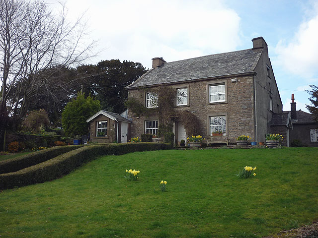
Birkrigg Park, Cumbria
- Overview Map Street View Birkrigg Park is a hamlet in Cumbria, located about 3 miles south of Kendal and half mile north-east of the larger hamlet of Summerlands. The farmhouse …
Co-Curate Page
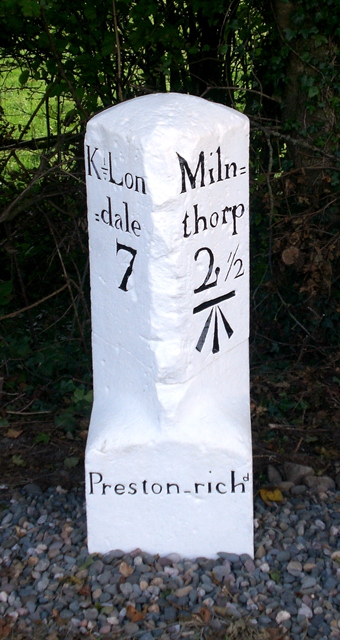
Old Milestone, B6385, Crooklands
- Overview Map Street View This old milestone is located by the B6385 road, to the south-west of Lane Farm in Crooklands. The milestone was erected by the Kendal, Kirkby Lonsdale, …

Co-Curate Page
Crooklands Aqueduct, Lancaster Canal
- Overview Map Street View At the south of Crooklands, by Milton Lane, is an aqueduct carrying the Lancaster Canal over Peasey Beck. The aqueduct, with two shallow elliptical arches, was …
Co-Curate Page
Crooklands Bridge, Lancaster Canal
- Overview Map Street View Crooklands Bridge carries the B6385 road over the Lancaster Canal in Crooklands. The bridge was built in c.1818 by engineer, John Fletcher, to the original designs …
Co-Curate Page
Birkrigg Park, Cumbria
- Overview Map Street View Birkrigg Park is a hamlet in Cumbria, located about 3 miles south of Kendal and half mile north-east of the larger hamlet of Summerlands. The farmhouse …


")
