Topics > Civil Parishes in Cumbria > Mansergh Civil Parish > Historic Buildings and Monuments in Mansergh
Historic Buildings and Monuments in Mansergh
Listed buildings and scheduled monuments in Mansergh Civil Parish, Cumbria, from the National Heritage List for England[1]. Use the Search (below) if looking for a specific building / monument.
| Structure | List No. | Grade | Built~ | Note |
|---|---|---|---|---|
| Barn Approximately 30 Metres to South of Fleshbeck | 1138291 | II | C18th | Fleshbeck |
| Barn at SD 594 832 | 1146352 | II | C18th | Bannister Barn, Old Town |
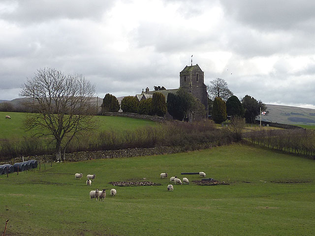
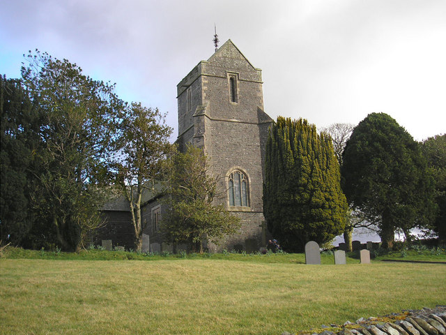
| Church of St Peter | 1086857 | II | 1880 | By Paley and Austin |
| Fleshbeck | 1311906 | II | 1717 | Fleshbeck |
| Kennel Range to North of Rigmaden Hall | 1335953 | II | C19th | Rigmaden Park |
| Mansergh War Memorial | 1457159 | II | c.1920 | Mansergh |
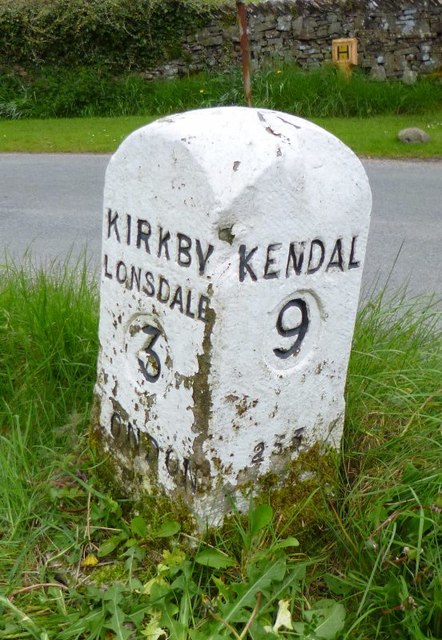
| Milestone at Corner of Old Scotch Road | 1086856 | II | C19th | B6254, Old Town |
| Outbuilding Approximately 20 Metres to South-East of Fleshbeck | 1335931 | II | 1746 | Fleshbeck |
| Outbuilding to North of Rigmaden Hall | 1086855 | II | C19th | Rigmaden Park |
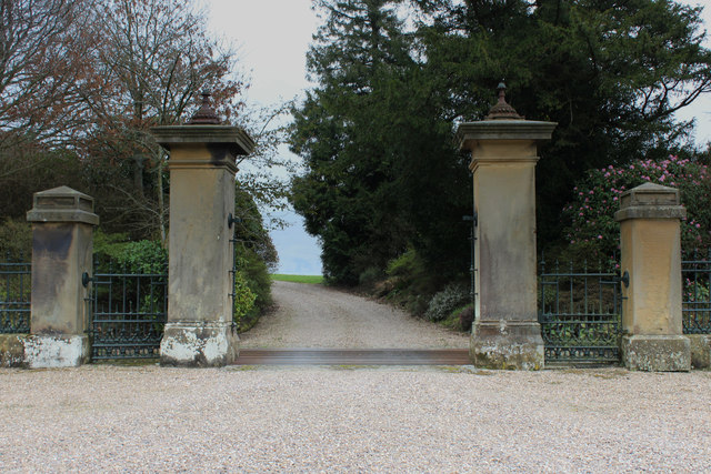
| Railings Running for 47 Metres Gates and Piers to West of Rigmaden Park | 1335952 | II | 1825 | Rigmaden Park |
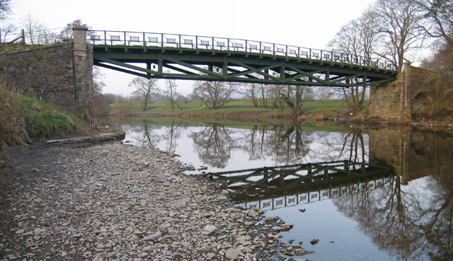
| Rigmaden Bridge | 1086894 | II | 1880s | West of Rigmaden |
| Rigmaden Hall | 1086853 | II | 1825 | aka Rigmaden Park |
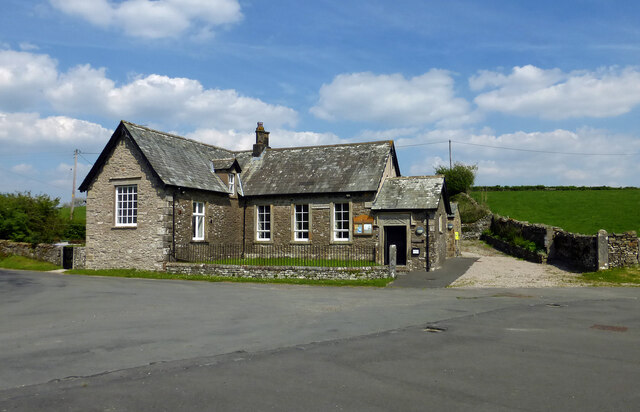
| Rigmaden School and School House | 1335955 | II | 1839 | Now Mansergh Community Hall |
| Stable Range to North of Rigmaden Hall | 1086854 | II | C19th | Rigmaden Park |
| The Durham Ox | 1335954 | II | C18th | House, Old Town |
Primary source: the National Heritage List for England - NHLE is the register of nationally protected historic buildings and sites in England, including listed buildings, scheduled monuments, protected wrecks, registered parks and gardens, and battlefields. The list is maintained by Historic England. Check NHLE for updates and new entries. Secondary sources: British Listed Buildings.
Co-Curate Page
Church of St Peter, Mansergh
- Overview Map Street View Inside St Peter's Church, on Chapel Lane in Mansergh, was built in 1880 by the renowned architects Paley and Austin. It replaced an earlier church of 1726, …
Co-Curate Page
Mansergh Community Hall
- Overview Map Street View Mansergh Community Hall serves the community of Mansergh Civil Parish and beyond. It is run as a registerd charity, hosting community events, and the rooms are …
Co-Curate Page
Rigmaden Bridge
- Overview Map Street View Rigmaden Bridge is a single lane road brdge over the River Lune, located to the west of Rigmaden in Cumbria. It straddles the civil parishes of …
Co-Curate Page
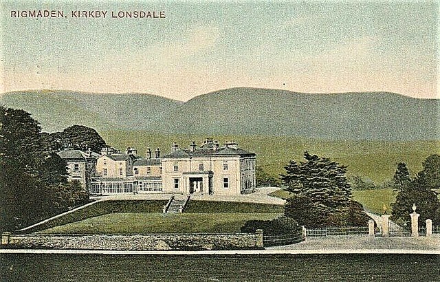
Rigmaden Park
- Overview Map Street View Rigmaden Park (aka Rigmaden Hall) is a large country house, located about 3½ miles north of Kirkby Lonsdale. The house is built on the site of …
Co-Curate Page
Milestone by the B6254, Old Town, Mansergh
- Overview Map Street View There is an old milestone by the B6254, at the junction with Old Scotch Lane, in Old Town, Mansergh. The milestone is though to date from …
Co-Curate Page
Gates Piers and Railings, Rigmaden Park
- Overview Map Street View The gate piers and railings of the west entrance to Rigmaden Park date from 1825. They are by Francis Webster, built at the same time as …

Co-Curate Page
Mansergh War Memorial
- Overview Map Mansergh War Memorial is located in the churchyard of St Peter's Church, Mansergh High Lane, in Mansergh. The memorial erected in c.1920 and commemorates five local servicemen who …

Co-Curate Page
Bannister Barn, Old Town
- Overview Map Street View Bannister Barn, is located near Mireside Farm, in Old Town, Mansergh. The large stone rubble barn is thought to date from the 18th century. It is …

Co-Curate Page
Church of St Peter, Mansergh
- Overview Map Street View Inside St Peter's Church, on Chapel Lane in Mansergh, was built in 1880 by the renowned architects Paley and Austin. It replaced an earlier church of 1726, …
Co-Curate Page
Mansergh Community Hall
- Overview Map Street View Mansergh Community Hall serves the community of Mansergh Civil Parish and beyond. It is run as a registerd charity, hosting community events, and the rooms are …
Co-Curate Page
Rigmaden Bridge
- Overview Map Street View Rigmaden Bridge is a single lane road brdge over the River Lune, located to the west of Rigmaden in Cumbria. It straddles the civil parishes of …
Co-Curate Page
Rigmaden Park
- Overview Map Street View Rigmaden Park (aka Rigmaden Hall) is a large country house, located about 3½ miles north of Kirkby Lonsdale. The house is built on the site of …
Co-Curate Page
Milestone by the B6254, Old Town, Mansergh
- Overview Map Street View There is an old milestone by the B6254, at the junction with Old Scotch Lane, in Old Town, Mansergh. The milestone is though to date from …
Co-Curate Page
Gates Piers and Railings, Rigmaden Park
- Overview Map Street View The gate piers and railings of the west entrance to Rigmaden Park date from 1825. They are by Francis Webster, built at the same time as …
Co-Curate Page
Mansergh War Memorial
- Overview Map Mansergh War Memorial is located in the churchyard of St Peter's Church, Mansergh High Lane, in Mansergh. The memorial erected in c.1920 and commemorates five local servicemen who …