Topics > Civil Parishes in Cumbria > Brampton Civil Parish > Historic Buildings and Monuments in Brampton, Cumbria
Historic Buildings and Monuments in Brampton, Cumbria
Listed buildings and scheduled monuments in Brampton Civil Parish, Carlisle, Cumbria from the National Heritage List for England[1]. Use the Search (below) if looking for a specific building / monument.
| Structure | List No. | Grade | Built~ | Notes |
|---|---|---|---|---|
| No. 10, Longtown Road | 1087635 | II | ||
| Nos. 12-22, Market Place | 1087640 | II | ||
| Nos. 13, 15 and 17, Carlisle Road | 1137063 | II | ||
| Nos. 15 and 16, Milton Village | 1335559 | II | ||
| No. 4, Market Place | 1137311 | II | ||
| No. 52, Front Street | 1312488 | II | ||
| Nos. 54 and 56, Front Street | 1087668 | II | ||
| No. 63, Main Street | 1087638 | II | ||
| B Warwick Sporting Shop and Milburn and Son | 1335551 | II | ||
| Bank Court | 1087662 | II | ||
| Bank House | 1087637 | II | ||
| Barclays Bank | 1087667 | II | ||
| Barley Stack Inn | 1087664 | II | ||
| Boat House East of Naworth Castle | 1087644 | I | c.1520 | Former bote (fuel) store for the castle |
| Brackenfell | 1388267 | II | ||
| Brampton Sports, Flat Above and Antique Shop | 1087671 | II | ||
| Breconhill | 1087648 | II | ||
| Byre North East of Cumcatch | 1312195 | II | ||
| Cambeck Bridge | 1335527 | II | ||
| Capon Tree Monument | 1335531 | II | ||
| Cartmell Mawson and Main, Solicitors Office | 1137223 | II | ||
| Church Cottage | 1087670 | II | ||
| Church House | 1137072 | II | ||
| Church of St Martin (old church) | 1087645 | II* | C12th | On Roman site |
| Church of St Martin | 1137170 | I | 1878 | By Philip Webb |
| Cotehill Farmhouse | 1312203 | II | ||
| Croft House | 1335530 | II | ||
| Crooked Holme Farmhouse | 1137634 | II | ||
| Cumcatch | 1087649 | II | ||
| E and D Young, Jewellers, T and M Savage, Freezer Food Centre and Flat Above | 1137221 | II | ||
| Flat | 1335552 | II | ||
| Four Gables | 1087651 | II* | 1879 | House by by Philip Webb |
| Garth House | 1087673 | II | ||
| Gatehouse East of Naworth Castle | 1137508 | I | c.1520 | |
| Gatepiers and Joining Wall, to South of Milton Lodge | 1087642 | II | ||
| Gatepiers and Walls South of Castlesteads | 1335560 | II | ||
| Greenlane House | 1335528 | II | ||
| Harrison's Grocers and Flat Above | 1137178 | II | ||
| Hollinstone Farmhouse | 1137688 | II | ||
| Howard Arms Hotel | 1335533 | II | ||
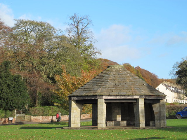
| Howard Memorial Shelter | 1087647 | II | c.1930 | The sands, Brampton |
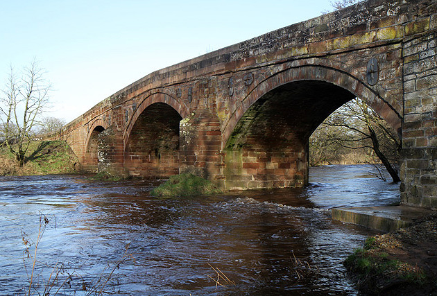
| Irthing Bridge | 1087659 | II | 1729 | With later alterations |
| Jobson's Chemists and Midland Bank | 1137364 | II | ||
| Jopsons Farm Shop | 1137299 | II | ||
| Laurel House | 1335555 | II | ||
| Lawson Masonic Hall | 1087641 | II | ||
| Lodge South of Castlesteads | 1087650 | II | ||
| Lodge to North East of Milton Hall | 1137389 | II | ||
| Lorne Terrace | 1335532 | II | ||
| Mark Terrace | 1137284 | II | ||
| Mclelland Electrical Shop | 1137107 | II | ||
| Middle Farmhouse | 1335561 | II | ||
| Milestone at NGR NY 52180 62100 | 1335554 | II | ||
| Milestone at NGR NY 50500 60380 | 1087661 | II | ||
| Milestone at NGR NY 51910 59480 | 1335529 | II | ||
| Milestone at NGR NY 52130 60805 | 1087665 | II | ||
| Milestone at NGR NY 53650 61210 | 1087660 | II | ||
| Milestone at NGR NY 55250 61620 | 1087658 | II | ||
| Milestone at NGR NY 56690 61990 | 1335526 | II | ||
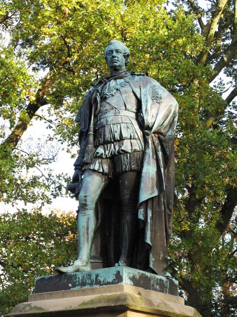
| Monument on Brampton Mote | 1087663 | II | 1870 | Statue of the 7th Earl of Carlisle |
| Moot Hall | 1137330 | II* | 1817 | Market Square |
| Mote Cottage | 1137591 | II | ||
| Naworth Castle | 1087643 | I | C13th | Restored by Anthony Salvin in 1844. |
| New Bridge Hotel | 1087634 | II | ||
| Old Church Farmhouse | 1087646 | II* | C14th | Former vicar's pele |
| Oulton House | 1312504 | II | ||
| Police Station and Magistrates' Court | 1087636 | II | ||
| Post Office | 1087672 | II | ||
| Prince Charlie's House | 1087632 | II | ||
| Prospect House | 1087666 | II | ||
| Ridge House | 1335553 | II | ||
| Rockingham Coffee House | 1312430 | II | ||
| Scarrow Hill | 1408870 | II | ||
| Scotch Arms Hotel | 1335556 | II | ||
| Solway Bakery Company and Dental Surgery | 1312373 | II | ||
| St Martins Hall | 1087669 | II | ||
| The Hollies | 1137291 | II | ||
| The Nag's Head Public House | 1335558 | II | ||
| The Sewing Box | 1087631 | II | ||
| Thompson Brothers Meals (Behind United Reformed Church) | 1087639 | II | ||
| Tree House | 1312219 | II | ||
| Trustee Savings Bank | 1335557 | II | ||
| Walled Garden East of Naworth Castle | 1137558 | II | ||
| White Lion Hotel | 1087633 | II | ||
| Brampton Old Church Roman fort and the medieval Church of St Martin | 1014586 | n/a | Scheduled Monument | |
| Bowl barrow 760m SSE of Old Church | 1014584 | n/a | Scheduled Monument | |
| The Mote Castle mound, medieval motte castle and site of late medieval beacon | 1013967 | n/a | Scheduled Monument | |
| Bowl barrow 710m south east of Old Church | 1014583 | n/a | Scheduled Monument | |
| Tower Tye ringwork | 1013969 | n/a | Scheduled Monument | |
| Romano-British farmstead and associated enclosure 770m ESE of Old Church | 1014580 | n/a | Scheduled Monument | |
| Written Rock of Gelt: Roman quarry inscriptions | 1014582 | n/a | Roman | Scheduled Monument |
| Boothby Roman fort | 1014585 | n/a | Roman | Scheduled Monument |
| Four Romano-British farmsteads 370m south east of Old Church | 1015420 | n/a | Scheduled Monument | |
| Lanercost Bridge | 1007105 | n/a | c.1724 | Scheduled Monument. Partly in Burtholme CP. |
| Brampton Conservation Area | - | n/a | Conservation Area |
Primary source: the National Heritage List for England - NHLE is the register of nationally protected historic buildings and sites in England, including listed buildings, scheduled monuments, protected wrecks, registered parks and gardens, and battlefields. The list is maintained by Historic England. Check NHLE for updates and new entries. Secondary sources: British Listed Buildings.
Co-Curate Page
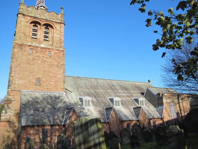
Church of St Martin
- Overview About St Martin's Church Map Street View St Martin's Church on Front Street in Brampton was built 1874-1878, replacing the old parish church, which was located outside the town. …
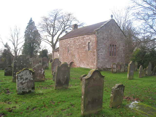
Co-Curate Page
Old Church
- Overview Map Street View The old Church of St Martin at Brampton, Carlisle, was built in the 12th century by the River Irthing on the site of a Roman fort. …
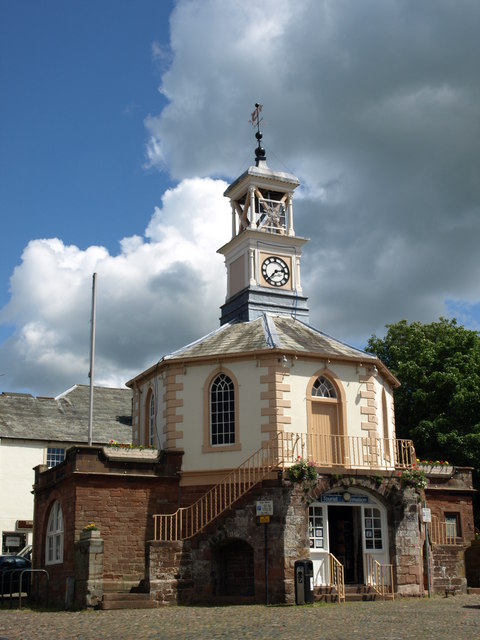
Co-Curate Page
Moot Hall
- Overview Map Street View Moot Hall is located on the Market Square in Brampton. It was built in 1817 for the Earl of Carlisle, replacing an earlier 17th century hall. Courts were …
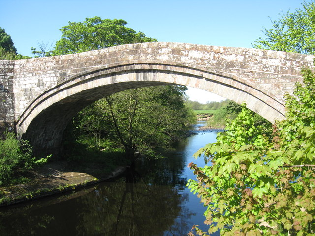
Co-Curate Page
Lanercost Bridge
- The old red sandstone bridge at Lanercost was built in c.1724. The bridge has two arches, the larger arch spans the River Irthing and the smaller one spans the millstream …
Co-Curate Page
Statue of the 7th Earl of Carlisle
- Statue of the 7th Earl of Carlisle on The Mote, Brampton.
Co-Curate Page
Howard Memorial Shelter, Brampton
- Overview Map Street View The octagonal shelter on The Sands in Brampton was built c.1930 and is inscribed with a dedication to George and Rosalind Howard. The memorial shelter is …

Co-Curate Page
Boothby Roman Fort
- There was a Roman fortlet (no visible remains today) at a strategic position overlooking the River Irthing, located to the north-west of Boothby in Cumbria. It was built in the …
Co-Curate Page
Irthing Bridge, near Brampton
- Overview Map Street View Irthing Bridge carries the A6071 road over the River Irthing, north-west of Brampton in Cumbria. The 3 arched stone bridge was built in c.1729 and altered …

Co-Curate Page
Church of St Martin
- Overview About St Martin's Church Map Street View St Martin's Church on Front Street in Brampton was built 1874-1878, replacing the old parish church, which was located outside the town. …
Co-Curate Page
Old Church
- Overview Map Street View The old Church of St Martin at Brampton, Carlisle, was built in the 12th century by the River Irthing on the site of a Roman fort. …
Co-Curate Page
Moot Hall
- Overview Map Street View Moot Hall is located on the Market Square in Brampton. It was built in 1817 for the Earl of Carlisle, replacing an earlier 17th century hall. Courts were …
Co-Curate Page
Lanercost Bridge
- The old red sandstone bridge at Lanercost was built in c.1724. The bridge has two arches, the larger arch spans the River Irthing and the smaller one spans the millstream …
Co-Curate Page
Statue of the 7th Earl of Carlisle
- Statue of the 7th Earl of Carlisle on The Mote, Brampton.
Co-Curate Page
Howard Memorial Shelter, Brampton
- Overview Map Street View The octagonal shelter on The Sands in Brampton was built c.1930 and is inscribed with a dedication to George and Rosalind Howard. The memorial shelter is …
Co-Curate Page
Boothby Roman Fort
- There was a Roman fortlet (no visible remains today) at a strategic position overlooking the River Irthing, located to the north-west of Boothby in Cumbria. It was built in the …

