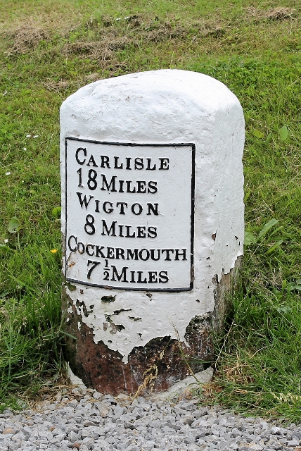
Topics > Boustead Hill > Canal Mile Marker, Boustead Hill

Canal Mile Marker, Boustead Hill


There is an old Mile Marker at the north of Boustead Hill, which is a remider that the Carlisle Canal once passed here. The canal closed in 1853, then was filled in to become a railway line. Today, the Hadrian's Wall Path national trail follows the dismantled railway bed here.

Boustead Hill Carlisle Canal Milestone
from Geograph (geograph)
Canal Mile Marker, Boustead Hill

Pinned by Simon Cotterill
from Geograph (geograph)
Route of former railway

Pinned by Simon Cotterill

Comments

Add a comment or share a memory.

Login to add a comment. Sign-up if you don't already have an account.


Milestone id: CAR-06
Unitary Auth: Cumberland
County: Cumbria

ABOUT US

Co-Curate is a project which brings together online collections, museums, universities, schools and community groups to make and re-make stories and images from North East England and Cumbria. Co-Curate is a trans-disciplinary project that will open up 'official' museum and 'un-officia'l co-created community-based collections and archives through innovative collaborative approaches using social media and open archives/data.

LATEST SHARED RESOURCES