Topics > Heritage Sites > Hadrian's Wall > Wall Mile 31 > Brocolitia Roman Fort
Brocolitia Roman Fort
Hadrian's Wall - Wall Mile 31 - Brocolitia
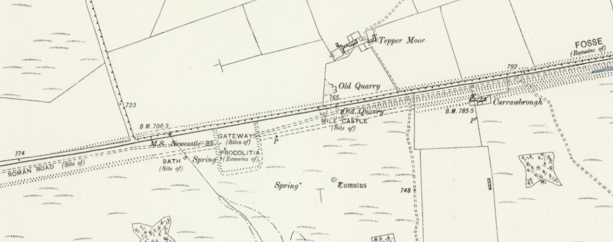
Extract showing Brocolitia on old OS Map, 1888.
Brocolitia (Carrawburgh) was a fort on Hadrian's Wall in Wall Mile 31. The fort was built (c. AD 130), after the completion of the Wall, to fill a gap between other forts. It is thought to have housed around 500 soldiers until near the end of Roman rule.
Key features of the site include extensive earthworks, remains of its granaries, headquarters, and bathhouse. The site includes the remains of a sizable Vicus (civilian settlement), located outside the fort to the south and west. Like the fort, it survives well as a series of earthworks and buried features. Most notably, Brocolitia includes the well-preserved Temple of Mithras and Coventina's Well shrine. Whilst the site offers limited visible structures, it is of significant archaeological importance. Brocolitia is managed by English Heritage.


from Flickr (flickr)
Carrawbrough Roman Fort, (Brocolitia), Hadrians wall, UK 24072019, jcw1967
Pinned by Simon Cotterill

from Flickr (flickr)
Carrawbrough Roman Fort, (Brocolitia), Hadrians wall, UK 24072019, jcw1967
Pinned by Simon Cotterill

from Flickr (flickr)
Traces of Carrawburgh Fort to the north of the Temple of Mithras, Hadrian's Wall
Pinned by Simon Cotterill

from https://www.english-heritage.…
Carrawburgh Roman Fort and Temple of Mithras - Hadrian's Wall
- Visitor information and a section on it's history. "Carrawburgh Roman Fort is one of 16 forts along the 73-mile long Hadrian’s Wall, which was begun around AD 122. Carrawburgh housed …
Added by
Simon Cotterill

from https://historicengland.org.u…
Carrawburgh Roman fort and Hadrian's Wall and vallum between the field boundary east of the fort and the field boundary west of Coventina's Well in wall mile 31 - List Entry
- ...The wall fort at Carrawburgh and its associated section of Hadrian's Wall and associated features survives well as a series of turf covered and upstanding stone remains. It is one …
Added by
Simon Cotterill

from Flickr (flickr)
Carrawbrough Roman Fort, (Brocolitia), Hadrians wall, UK 24072019, jcw1967
Pinned by Simon Cotterill
from Flickr (flickr)
Carrawbrough Roman Fort, (Brocolitia), Hadrians wall, UK 24072019, jcw1967
Pinned by Simon Cotterill
from Flickr (flickr)
Traces of Carrawburgh Fort to the north of the Temple of Mithras, Hadrian's Wall
Pinned by Simon Cotterill
from https://www.english-heritage.…
Carrawburgh Roman Fort and Temple of Mithras - Hadrian's Wall
- Visitor information and a section on it's history. "Carrawburgh Roman Fort is one of 16 forts along the 73-mile long Hadrian’s Wall, which was begun around AD 122. Carrawburgh housed …
Added by
Simon Cotterill
from https://historicengland.org.u…
Carrawburgh Roman fort and Hadrian's Wall and vallum between the field boundary east of the fort and the field boundary west of Coventina's Well in wall mile 31 - List Entry
- ...The wall fort at Carrawburgh and its associated section of Hadrian's Wall and associated features survives well as a series of turf covered and upstanding stone remains. It is one …
Added by
Simon Cotterill


