Castle Hill, Pennington
-
Description
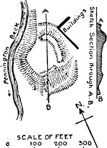
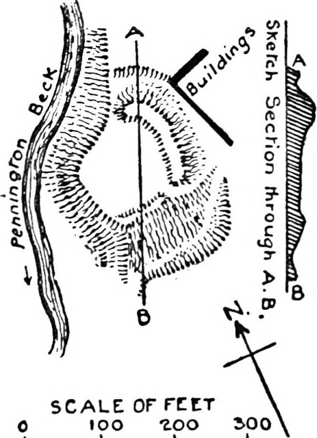
Title: The Victoria history of the county of Lancaster; Identifier: cu31924088434547 Year: https://www.flickr.com/search/?tags=bookyear1906">1906 (https://www.flickr.com/search/?tags=bookdecade1900">1900s) Authors: https://www.flickr.com/search/?tags=bookauthorFarrer_William_1861_1924_ed">Farrer, William, 1861-1924, ed; https://www.flickr.com/search/?tags=bookauthorBrownbill_J_joint_ed">Brownbill, J. , joint ed Subjects: https://www.flickr.com/search/?tags=booksubjectNatural_history">Natural history Publisher: https://www.flickr.com/search/?tags=bookpublisherLondon_Constable_">London [Constable] Contributing Library: https://www.flickr.com/search/?tags=bookcontributorCornell_University_Library">Cornell University Library Digitizing Sponsor: https://www.flickr.com/search/?tags=booksponsorMSN">MSN View Book Page: https://archive.org/stream/cu31924088434547/#page/n579/mode/1up" rel="nofollow">Book Viewer About This Book: https://archive.org/details/cu31924088434547" rel="nofollow">Catalog Entry View All Images: https://www.flickr.com/search/?tags=bookidcu31924088434547">All Images From Book Click here to https://archive.org/stream/cu31924088434547/#page/n579/mode/1up" rel="nofollow">view book online to see this illustration in context in a browseable online version of this book. Text Appearing Before Image: A HISTORY OF LANCASHIRE peninsula, which entered at Conishead Bank, and followed the line now called Red Lane. It is possible the site was originally chosen as command- ing this road. , At this point the stream called Pennington Beck runs south m a rather deep ravine, and on the east bank the cliff projects in a rather sharp elbow or angle. This elbow has been isolated by a semicircular rampart and tosse forming a quadrant-shaped inclosure, the ward of which measures 156 ft. by 1-22 ft. In digging the fosse the earth has been thrown inwards, making a rampart the highest point of which (on the north) seems about 12 ft. above the ward level. The ditch itself measures about 45 ft. from the rampart top to the outer edge, but was never intended to hold water. The precipitous slope which forms the north-west and south-west sides of the inclosure probably is much the same now as when the fortress was made, for there seems no real reason to suppose (as has been suggested) that part of the inclosed area has been washed away in his- torical times. No trace of rampart or parapet exists on the edge, but a strong palisade alone would make a good defence here. The exca- vated defences are strongest on the north side, as there the ground is level outside, whereas on the south there is a moderate slope. There is a break in the rampart on the south-east which seems an ancient entrance. Pennington is a pure Anglian name, and it appears in the Domesday Survey with two carucates. From time immemorial the manor has belonged to the Pennington family (now represented by Lord Muncaster), whose ancestors are said to have abandoned it as a seat in the thirteenth century. The ' capital messuage' of Sir William Pennington is, however, mentioned in a dispute as late as 1318, and the Castle Hill may therefore be the site of the Penningtons' early home, or it may be more ancient. The great tumulus half-a-mile to the south-east (mentioned elsewhere) may perhaps guard the secret of the origin of Castle Hill as well as its own. Text Appearing After Image: SCALE OFFCtT 100 ZOO Castle Hill, Pennington (Classes E and F) Aldingham.—Aldingham Mote stands on the east coast of the Furness promontory overlooking Morecambe Bay, and situated at a point approxi- mately five miles south of Ulverston and four miles east of Furness Abbey. The position is a striking one, being on the actual edge of the sea cliff. The earthworks are of two parts, probably of different dates. The ' Mote' itself is of the mount and court type, and occupies the highest position in the immediate vicinity, the ground shelving off on the north, west, and south. The mount, with its fosse, measures about 220 ft. through its longest axis, and its summit is 15 ft. above the present level of the surrounding ground, and probably between 25 ft. and 30 ft. above the 556 Note About Images Please note that these images are extracted from scanned page images that may have been digitally enhanced for readability - coloration and appearance of these illustrations may not perfectly resemble the original work. -
Owner
Internet Archive Book Images -
Source
Flickr (Flickr) -
License
What does this mean? No known copyright restrictions -
Further information
Link: https://www.flickr.com/photos/126377022@N07/20801442681/
Resource type: Image
Added by: Edmund Anon
Last modified: 7 years, 8 months ago
Viewed: 729 times
Picture Taken: 1906-01-01T00:00:00 -
Co-Curate tags


