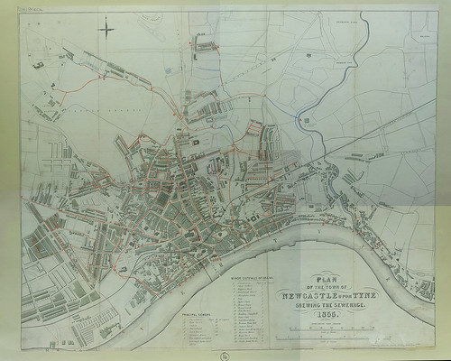
Plan of the town of Newcastle upon Tyne shewing the sewerage, 1855


-
Description
Newcastle Upon Tyne 1855. Bryson (T). Plan of the town of Newcastle upon Tyne shewing the sewerage. 1855. Scale 200 yards to 1" Our ref. C2 672675 00 D7 / L912.2 N536 This map is believed to be in the public domain, which means the copyright has expired and you are welcome to re-use it in any way you like. There is no requirement for you to ask for our permission to use this digitised copy, but we would love it if you could mention you got the map from the Newcastle Libraries' collections. -
Owner
Newcastle Libraries -
Source
Newcastle libraries (Flickr) -
License
What does this mean? Public Domain Mark
-
Further information
Link: https://www.flickr.com/photos/39821974@N06/26207904206/
Resource type: Image
Last modified: 9 years, 4 months ago
Viewed: 904 times
Picture Taken: Unknown -
Co-Curate tags
")


