Remains of Dukesfield Smelt Mill

-
Description
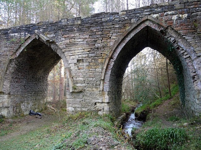
"The southern of the two arches spans the Hall Burn. Its course here was artificially altered and acted as an outlet for water from the mill race that was unused by the mill waterwheels. The northern arch bridged the track that curved round and up to Dukesfield, providing access to the Lead Road used by ponies to carry lead pigs (the product of smelting) to Tyneside. Dukesfield Smelt Mill Only visible remains of the late C18th lead smelting mill at Dukesfield. It consists of a high wall with two Gothic arches lined with brick, the southernmost of which takes the route of the Hall Burn. To the south, the wall changes direction to run up the steep valley side. It is the remaining superstructure used to carry the flues from the smelting furnaces thought to be located in a former building due south of the arches to chimneys just above the valley side. In Allendale. long horizontal flues were built running up hillsides to remote chimneys, from which valuable deposits of lead and silver could be reclaimed. The Dukesfield Arches point uphill towards ‘Leadpipe Hill’ on the once open moorland a mile to the south. However, no flue was ever constructed here, and the run was quite short to chimneys just above the valley-side, and this may have been an early version. A smelt mill in this location was in operation by 1695. Production ended in 1834 and it was dismantled in 1837. In 1811, the mill consisted of 2 Roasting Furnaces (used for preliminary treatment of the lead ore), 5 Ore Hearths (to produce lead from roasted ore), 2 Slag Hearths (for second refinement of the slag arising from the Ore Hearths), 2 Refining and 1 Reducing Furnace (to extract silver). The lead ore (bouse) was carried to the smelt mill by trains of 25-50 pack-ponies (galloways) and later by carts. From Allenheads, two routes were used: either the Long Drag (track), via Ladle Well, Westburnhope, and Rowley Head to Whitley Chapel, or using Broadway (track) via Green Hill, Hangman Hill and Rawgreen. From Rookhope the route was via Hunstanworth, Bay Bridge, Pennypie, Ladycross and Dukesfield Hall. After smelting at Dukesfield Mill, pigs of lead weighing from 8 to 12 stone were carried by the Lead Road via Dukesfield Hall, Slaley, Scales Cross to Apperly Cross Roads. From here, new teams of ponies carried the lead onward to Blaydon Mills where it was manufactured into lead sheets and pipes. Returning ponies would carry provisions for the miners, and coal from Greymare Hill back to Dukesfield. A preliminary archaeological excavation was undertaken in October 2012 to support an application to the Heritage Lottery Fund for funds to conserve the arches and interpret the site for visitors. The remaining arches are a Grade II Listed Building." Photo by Andrew Curtis, 2012, and licensed for reuse under a Creative Commons Licence. -
Owner
Geograph.org.uk -
Source
Geograph (Geograph) -
License
What does this mean? Attribution-ShareAlike 2.0 Generic (CC BY-SA 2.0)
-
Further information
Link: http://www.geograph.org.uk/photo/3245483
Resource type: Text/Website
Added by: Simon Cotterill
Last modified: 10 years, 6 months ago
Viewed: 1319 times
Picture Taken: Unknown -
Co-Curate tags


