Medieval cross base near Brownrigg

-
Description
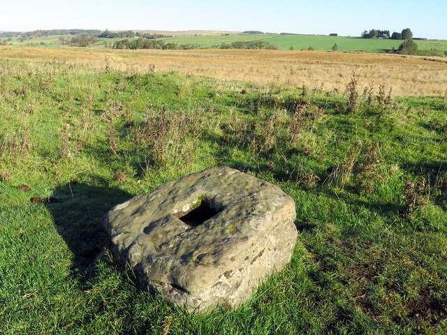
"Remains of a medieval wayside cross, situated in a slight hollow 20 metres west of Dere Street, the Roman road between Corbridge and Newstead in Scotland. The cross survives as a stone base, sub-rectangular in shape, 0.5m by 0.4m, with a central socket hole 0.1m square and 0.1m deep, and embedded in the ground, standing 0.2 metres above ground level. The position of the cross, alongside Dere Street, which continued in use as a routeway during the medieval period, supports the view that it is a medieval wayside cross; it may be associated with other wayside crosses known as The Golden Pots and likewise situated beside Dere Street [[4939042]], [[3433260]] Pastscape: www.pastscape.org.uk/hob.aspx?hob_id=17505 https://web.archive.org/web/20190811113317/https://www.pastscape.org.uk/hob.aspx?hob_id=17505 The medieval wayside cross, 200m NNW of Brownrigg is a Scheduled Monument (List Entry Number: 1017596): https://historicengland.org.uk/listing/the-list/list-entry/1017596" Photo by Andrew Curtis, 2018. -
Owner
Andrew Curtis -
Source
Geograph (Geograph) -
License
What does this mean? Creative Commons License
-
Further information
Link: http://www.geograph.org.uk/photo/5936332
Resource type: Image
Added by: Simon Cotterill
Last modified: 9 months ago
Viewed: 281 times
Picture Taken: 2018-10-10 -
Co-Curate tags


