Burnstones Viaduct on the (former) Haltwhistle to Alston branch line (west side)

-
Description
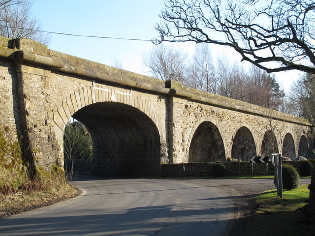
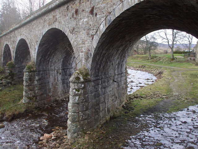
"Burnstones Viaduct crosses the A689, Thinhope Burn and a sike draining the rough pastures west of Side House. For info about the branch line, see https://www.south-tynedale-railway.org.uk . The geometry of the viaduct is unusual (possibly unique) in that the road arch is skewed one way to the line of the (former) railway , and the four arches that cross Thinhope Burn are skewed the other way - see the satellite image http://maps.google.co.uk/maps?q=Knaresdale+with+Kirkhaugh&hl=en&ll=54.88279,-2.50738&spn=0.001106,0.002438&sll=54.812167,-2.438685&sspn=0.035463,0.07802&oq=knaresdale&hnear=Knaresdale+with+Kirkhaugh,+Northumberland,+United+Kingdom&t=k&z=19 . The builders of the bridge overcame this civil engineering problem by means of a deep blind arch between the (elliptical) road arch and the northernmost of the four open (semi-circular) arches that cross the burn. So the viaduct appears to have six arches on the west side (the road arch, the blind arch and four open arches over the burn) and only five (all open arches) on the east side. For more information about the viaduct, see http://ds.dial.pipex.com/town/lane/jy40/page47.html. See also [[3420952]], [[3420963]], [[3420971]], [[3386487]] and [[3421015]]." Photo by Mike Quinn, 2013. -
Owner
Mike Quinn -
Source
Geograph (Geograph) -
License
What does this mean? Creative Commons License
-
Further information
Link: http://www.geograph.org.uk/photo/3386484
Resource type: Image
Added by: Simon Cotterill
Last modified: 11 months, 1 week ago
Viewed: 149 times
Picture Taken: 2013-02-27 -
Co-Curate tags
")


