Matfen Standing Stone

-
Description
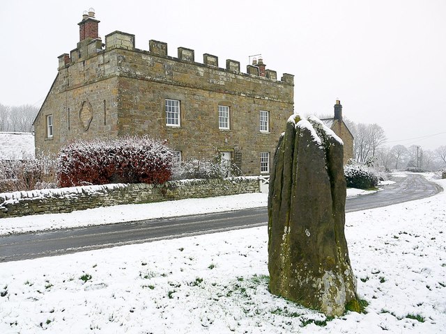
"Matfen Standing Stone, also known as the Stob Stone, is a Scheduled Ancient Monument, listed Grade II by Historic England (List entry Number: 1155462) https://historicengland.org.uk/listing/the-list/list-entry/1155462 The prehistoric sandstone monolith is about 7 ft. high and stands on the grass verge of the road opposite a farmhouse called Standing Stone Farm. It is likely to have been moved here from a previous location. The stone has cup marks near its base on three of its four sides and is naturally fluted [[5604362]] On three sides of its base, close to the ground, are many cup marks. It is not known if they were put there before or after the stone was erected. They are best seen in oblique sunlight. There are 29 cups and three fainter ones on the east side, five cups in an arc around a fainter cup on the north side, and 23 of various sizes on the west side. A 3D model made from 24 digital photos can be viewed here: https://skfb.ly/6uBVs A local farmer stated that the stone was ploughed up in a field at Moralees Farm near NY044743 before it was re-erected on the current site. If this is true, its original location would have been near the Ingoe Warrior Stone, possibly at the tumulus just to its SE. Interestingly, there is a Stob Hill about 200m NW of the Warrior Stone in Ingoe village. Old OS maps show the stone in its present location at least since the 1860s. Camden's Britannia, 2nd Ed. (1722) states that "W. Matfen is the seat of Sir William Blacket, Bart. And in an adjoining field is a circular mount with a cavity at top, and by it a stone nine feet high, three feet by one and a half thick, called the Stob stone." It is not clear where this mound was located. http://archaeologydataservice.ac.uk/era/section/panel/location.jsf?eraId=1477" Photo by Andrew Curtis, 2008. -
Owner
Andrew Curtis -
Source
Geograph (Geograph) -
License
What does this mean? Creative Commons License
-
Further information
Link: http://www.geograph.org.uk/photo/5604396
Resource type: Image
Added by: Simon Cotterill
Last modified: 6 years, 4 months ago
Viewed: 1079 times
Picture Taken: 2008-12-14 -
Co-Curate tags


