Image from page 194 of "The international geography" (1916)
Related Pages
-
Description
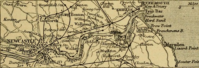
Identifier: internationalgeo1916mill Title: https://www.flickr.com/photos/internetarchivebookimages/tags/bookidinternationalgeo1916mill">The international geography Year: https://www.flickr.com/photos/internetarchivebookimages/tags/bookyear1916">1916 (https://www.flickr.com/photos/internetarchivebookimages/tags/bookdecade1910">1910s) Authors: https://www.flickr.com/photos/internetarchivebookimages/tags/bookauthorMill__Hugh_Robert__1861_1950">Mill, Hugh Robert, 1861-1950 Subjects: https://www.flickr.com/photos/internetarchivebookimages/tags/booksubjectGeography">Geography Publisher: https://www.flickr.com/photos/internetarchivebookimages/tags/bookpublisherNew_York___D__Appleton">New York : D. Appleton Contributing Library: https://www.flickr.com/photos/internetarchivebookimages/tags/bookcontributorUniversity_of_Connecticut_Libraries">University of Connecticut Libraries Digitizing Sponsor: https://www.flickr.com/photos/internetarchivebookimages/tags/booksponsorUniversity_of_Connecticut_Libraries">University of Connecticut Libraries View Book Page: https://archive.org/stream/internationalgeo1916mill/internationalgeo1916mill#page/n194/mode/1up" rel="noreferrer nofollow">Book Viewer About This Book: https://archive.org/details/internationalgeo1916mill" rel="noreferrer nofollow">Catalog Entry View All Images: https://www.flickr.com/photos/internetarchivebookimages/tags/bookidinternationalgeo1916mill">All Images From Book Click here to https://archive.org/stream/internationalgeo1916mill/internationalgeo1916mill#page/n194/mode/1up" rel="noreferrer nofollow">view book online to see this illustration in context in a browseable online version of this book. Text Appearing Before Image: ople ot the district, that the storesof iron and coal localised the greatest seat of textile manufactures in theworld. The lines of communication from north to south were necessarilycarried along the bordering plains. That on the east ran through the Valeof York and then along the coastal plain, where Berwick, with its longbridge over the Tweed, was an important stopping place, and until theend of the fifteenth century was frequently taken and retaken by Scottishand English armies. The North-Eastern Railway now follows this route.On the west the road followed the coastal plain, but turned northward upthe Lune valley to Carlisle, always an important border town. This is nowthe route of the London and North-Western Railway, but the MidlandRailway runs along the watershed of the Pennines, and descends by theEden valley to Carlisle, the importance of that junction being furtherenhanced by the cross-countny line from Newcastle through the Tynevalley, and the three main lines from Scotland. Text Appearing After Image: otiierFomt \^ Fig. So.—The Tync Ports. The Northumberland and Durham Coal-field.—The countiesof Northumberland and Durham are separated by the river Tyne, whichruns across the middle of the coal basin to the sea. Newcastle takes itsname from a castle erected immediately after the Norman conquest closeto the site of the ancient Roman bridge which gave origin to the town.The shipping of coal from Newcastle (called sea-coal in the old days)has gone on from the thirteenth century, and it is still the greatest coal- lyo The International Geography shipping port for coasting trade. The Tyne for ten miles, from Newcastleto the sea, has been deepened to admit large vessels, and the harbours ofNorth and South Shields at its mouth are included with the docks whichline the river as the Tyne Ports for custom-house purposes. Gateshead, onthe south side of the river, shares the industries of Newcastle, which arechiefly the manufacture of iron, machinery, and chemicals. The greatElswick Works, w Note About Images Please note that these images are extracted from scanned page images that may have been digitally enhanced for readability - coloration and appearance of these illustrations may not perfectly resemble the original work. -
Owner
Internet Archive Book Images -
Source
Flickr (Flickr) -
License
What does this mean? No known copyright restrictions -
Further information
Link: https://www.flickr.com/photos/126377022@N07/14799513803/
Resource type: Image
Added by: Pat Thomson
Last modified: 6 years, 11 months ago
Viewed: 1162 times
Picture Taken: 1916-01-01T00:00:00 -
Co-Curate tags


