Topics > Civil Parishes in Cumbria > Kirkoswald Civil Parish > Historic Buildings and Monuments in Kirkoswald Civil Parish
Historic Buildings and Monuments in Kirkoswald Civil Parish
Listed buildings and scheduled monuments in Kirkoswald Civil Parish, Cumbria, from the National Heritage List for England[1]. Use the Search (below) if looking for a specific building / monument.
| Structure | List No. | Grade | Built~ | Note |
|---|---|---|---|---|
| Nos. 1, 3 and 4, the Square | 1137423 | II | ||
| Anne Dale and Bridge Stores | 1312350 | II | ||
| Archway and Adjoining Wall, to East of Croglin Low Hall | 1137449 | II | C18th | Croglin Low Hall |
| Barn North West of Sickergill | 1144827 | II | ||
| Barn to West of Low Huddlesceugh | 1144825 | II | ||
| Barns North West of Fieldgarth | 1137425 | II | ||
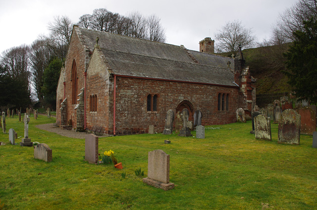
| Bell Tower North-East of Church of St Oswald | 1144818 | II* | 1743 | Kirkoswald |
| Black Bull and Adjoining House | 1144851 | II | ||
| Blunderfield Farmhouse and Barn | 1137433 | II | ||
| Busk Rigg and Barns Adjoining | 1327036 | II | ||
| Byre to North of Croglin Low Hall | 1137444 | II* | C16th | Croglin Low Hall |
| Church of St Oswald | 1327058 | II* | C12th | Kirkoswald |
| Croglin Low Hall | 1327062 | II* | C15th | |
| Crown Hotel | 1144812 | II | ||
| Demesne Farmhouse | 1144810 | II* | ||
| Eden Bank and Outbuilding | 1144850 | II | ||
| Eden Bridge | 1137397 | II | ||
| Entrance Gateway South East of the College | 1144816 | II | ||
| Featherstone Arms Hotel | 1137318 | II | ||
| Fieldgarth | 1327061 | II | ||
| Fog Close | 1144824 | II | ||
| Former Congregational Church | 1144819 | II | ||
| Gatehouse to East of Croglin Low Hall | 1144823 | II | C17th | Croglin Low Hall |
| Gatepiers to North of Church of St Oswald | 1137394 | II | ||
| George House | 1144852 | II | ||
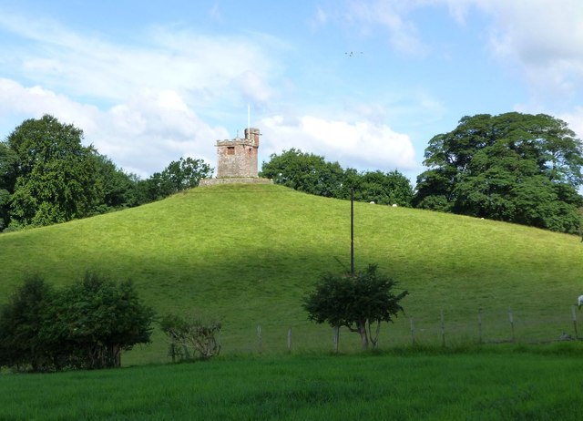
| High College | 1327037 | II | ||
| Hill House | 1144811 | II | ||
| Hollybank View | 1327060 | II | ||
| Huddlesceugh Hall and Adjoining Barn | 1327023 | II | ||
| K6 Telephone Kiosk, the Square | 1137474 | II | ||
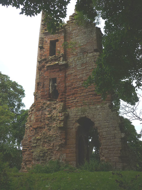
| Kirkoswald Castle | 1327059 | II | C13th | Ruins on private land. |
| Kirkoswald War Memorial | 1463175 | II | ||
| Low Huddlesceugh | 1137450 | II | ||
| Manor House | 1144853 | II | ||
| Manorial Boundary Stone, East of Raven Bridge | 1327024 | II | ||
| Methodist Church | 1137410 | II | 1905 | Renwick |
| Midland Bank | 1312386 | II | ||
| Mill House | 1144813 | II | ||
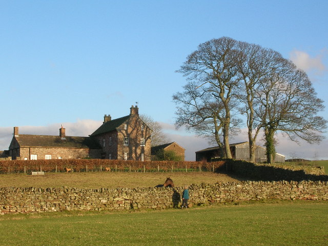
| Nether Haresceugh | 1312296 | II* | 1612 | Farmhouse |
| Ona Ash | 1137312 | II* | ||
| Outhwaite and Adjoining Outbuildings | 1144826 | II | ||
| Park View | 1144822 | II | ||
| Post Office | 1137415 | II | ||
| Scales Fold and Adjoining Byre | 1312298 | II | ||
| Scarrowmanwick and Adjoining Barn | 1327025 | II | ||
| Sickergill and Adjoining Barn | 1137467 | II | ||
| Stable Block South of the College | 1327057 | II | ||
| Terrace Wall and Steps West of the College | 1144817 | II | ||
| The College | 1327056 | I | ||
| The College and Adjoining Unnamed House | 1144820 | II | ||
| The College Flat, South of the College | 1144815 | II | ||
| The Mains and Outbuilding to Left | 1137454 | II | ||
| The Old Mill | 1144814 | II | ||
| Village Stocks, West Side of War Memorial | 1144821 | II | ||
| Wall Surrounding Churchyard of Church of St Oswald | 1137384 | II | ||
| Westgarth Hill and Adjoining Barn | 1144828 | II | ||
| Wordsley House | 1312384 | II | ||
| Kirkoswald Castle moated site | 1019939 | n/a | Scheduled Monument | |
| Medieval moated site W of St Oswald's Church | 1007088 | n/a | Medieval | Scheduled Monument |
| Haresceugh Fell medieval dispersed settlement 100m south west of Busk lime kiln | 1021185 | n/a | Scheduled Monument | |
| Eden Bridge | 1007087 | n/a | Scheduled Monument | |
| Kirkoswald Conservation Area | - | n/a | Conservation Area |
Primary source: the National Heritage List for England - NHLE is the register of nationally protected historic buildings and sites in England, including listed buildings, scheduled monuments, protected wrecks, registered parks and gardens, and battlefields. The list is maintained by Historic England. Check NHLE for updates and new entries. Secondary sources: British Listed Buildings.
Co-Curate Page
Kirkoswald Castle
- Overview About Kirkoswald Castle Map Street View The ruins of Kirkoswald Castle are located to the south-east of Kirkoswald in Cumbria. A licence to crenellate (fortify) an existing building was granted …

Co-Curate Page
Methodist Church, Renwick
- Overview Map Street View The Methodist Church in Renwick is built in red sandstone; it has a small central spire, and a distinctive battlemented porch and clock tower. The original …
Co-Curate Page
Nether Haresceugh
- Overview Map Street View Nether Haresceugh is a farm/hamlet located about 1½ miles north east of Kirkoswald in Cumbria. The red sandstone farmhouse here dates from 1612 with an extension …

Co-Curate Page
Croglin Low Hall
- Overview Map Street View Croglin Low Hall is located about 10 miles south-east of Carlisle and is about 2 miles south-west of the village of Croglin. It is situated near …

Co-Curate Page
Medieval moated site, Kirkoswald
- Scheduled Monument area - map data from Historic England c/o Open Data UK, under the Open Government Licence, imported into Google MyMaps, March 2026. This Medieval moated site is located …

Co-Curate Page
Kirkoswald Castle
- Overview About Kirkoswald Castle Map Street View The ruins of Kirkoswald Castle are located to the south-east of Kirkoswald in Cumbria. A licence to crenellate (fortify) an existing building was granted …
Co-Curate Page
Methodist Church, Renwick
- Overview Map Street View The Methodist Church in Renwick is built in red sandstone; it has a small central spire, and a distinctive battlemented porch and clock tower. The original …
Co-Curate Page
Nether Haresceugh
- Overview Map Street View Nether Haresceugh is a farm/hamlet located about 1½ miles north east of Kirkoswald in Cumbria. The red sandstone farmhouse here dates from 1612 with an extension …
Co-Curate Page
Croglin Low Hall
- Overview Map Street View Croglin Low Hall is located about 10 miles south-east of Carlisle and is about 2 miles south-west of the village of Croglin. It is situated near …


