Topics > Civil Parishes in Cumbria > Embleton and District Civil Parish > Historic Buildings and Monuments in Embleton CP, Cumbria
Historic Buildings and Monuments in Embleton CP, Cumbria
Listed buildings and scheduled monuments in Embleton Civil Parish, Cumbria, from the National Heritage List for England[1]. In the absence of a 'local list' other sites of interest may be included. Use the Search (below) if looking for a specific building / monument.
| Structure | List No. | Grade | Built~ | Note |
|---|---|---|---|---|
| Blue Bell Inn | 1145179 | II | C18th | Embleton |
| Boundary Stone Opposite Close Farmhouse | 1146359 | II | C19th | |
| Close Farmhouse and Barn Adjoining | 1311847 | II | C18th | |
| High Side and Barn Adjoining | 1145176 | II | 1771 | |
| Milestone Opposite Blue Bell Inn | 1145180 | II | C19th | |
| Milestone Outside of Close Farmhouse | 1326846 | II | C19th | |
| Mill House | 1146361 | II | C19th | |
| Scales Farmhouse and Barn Adjoining | 1146351 | II | C18th | |
| Shatton Hall | 1146344 | II | C17th | |
| Shatton Lodge | 1145177 | II | C18th | |
| Shatton Lodge Farmhouse | 1145178 | II | C17th | |
| Stanger House | 1145181 | II | 1695 | |
| Stanley Hall | 1146353 | II | C18th | |
| Wythop Mill Cottage and Stables | 1145182 | II | C17th | |
| Church of St Cuthbert | not listed | n/a | 1806 | |
| Embleton Moat | not listed | n/a | Medieval |
Primary source: the National Heritage List for England - NHLE is the register of nationally protected historic buildings and sites in England, including listed buildings, scheduled monuments, protected wrecks, registered parks and gardens, and battlefields. The list is maintained by Historic England. Check NHLE for updates and new entries. Secondary sources: British Listed Buildings.
Co-Curate Page
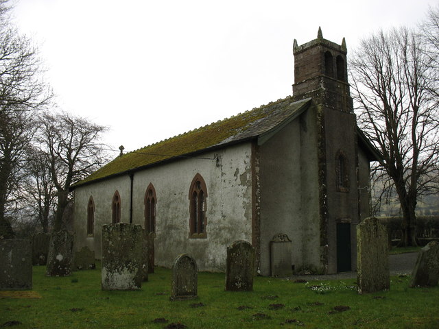
Church of St Cuthbert
- Overview Map Street View The church is in an isolated location, almost a mile south-west of the village of Embleton in Cumbria. The church was built 1806 on the site of …
Co-Curate Page
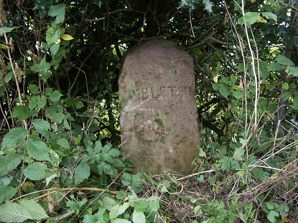
Old Boundary Stone by Close Farm, Embleton
- Overview Map Street View There is a mid-19th century parish boundary stone opposite the drive to Close Farm Close Farm, in the Civil Parish of Embleton, Cumbria. The rounded-top stone …
Co-Curate Page
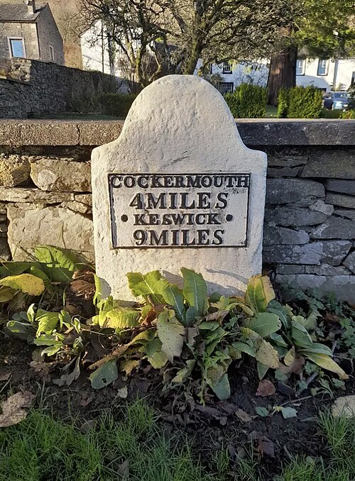
Old Milestone by Close Farm, Embleton
- Overview Map Street View COCKERMOUTH 4 MILES KESWICK 9 MILES

Co-Curate Page
Embleton Moat
- The archaeological remains of a Medieval moat are located about ½ mile south-west of St Cuthbert's Church in Embleton, Cumbria, and about 2 miles south-east of Cockermouth. Now largely filled …

Co-Curate Page
Church of St Cuthbert
- Overview Map Street View The church is in an isolated location, almost a mile south-west of the village of Embleton in Cumbria. The church was built 1806 on the site of …
Co-Curate Page
Old Boundary Stone by Close Farm, Embleton
- Overview Map Street View There is a mid-19th century parish boundary stone opposite the drive to Close Farm Close Farm, in the Civil Parish of Embleton, Cumbria. The rounded-top stone …
Co-Curate Page
Old Milestone by Close Farm, Embleton
- Overview Map Street View COCKERMOUTH 4 MILES KESWICK 9 MILES


