Topics > Northumberland > Morpeth > Bullers Green
Bullers Green
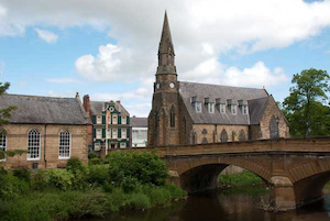
In the 19th century Bullers Green was recorded as a township, located just ouside Morpeth, but has since been subsumed into the town as it grew in size.
BULLER'S-GREEN, a township, in the parish, parliamentary borough, and union of Morpeth, W. division of Morpeth ward, N. division of Northumberland; containing 169 inhabitants. It comprises about 100 acres of land, tithe-free, adjoining the north and north-west boundaries of the town of Morpeth, and consists principally of one row of houses, in a curved line. The abbot of Newminster anciently had possessions in the place; and there was probably, some three centuries since, a bowling-green here, on "Bowles Green," a name now corrupted into Buller's-Green.
Extract from: A Topographical Dictionary of England comprising the several counties, cities, boroughs, corporate and market towns, parishes, and townships..... 7th Edition, by Samuel Lewis, London, 1848.

from https://keystothepast.info/se…
Bullers Green Steps (Morpeth)
- "A map of Morpeth dating to 1826 shows a number of stepping-stones crossing the River Wansbeck. There are now no remains to be seen here....."
Added by
Simon Cotterill

from https://keystothepast.info/se…
Bullers Green Steps (Morpeth)
- "A map of Morpeth dating to 1826 shows a number of stepping-stones crossing the River Wansbeck. There are now no remains to be seen here....."
Added by
Simon Cotterill