Topics > Tees Valley > Middlesbrough > Historic Buildings and Monuments in Middlesbrough
Historic Buildings and Monuments in Middlesbrough
| Structure | List No. | Grade | Built~ | Ward / Locality | Note |
|---|---|---|---|---|---|
| No. 1, Albert Road | 1136868 | II | 1873 | Central | |
| Nos. 11 and 13, Zetland Road | 1137392 | II | 1871 | Central | |
| Nos. 2,3 and 4, Exchange Place | 1136738 | II | 1870 | Central | |
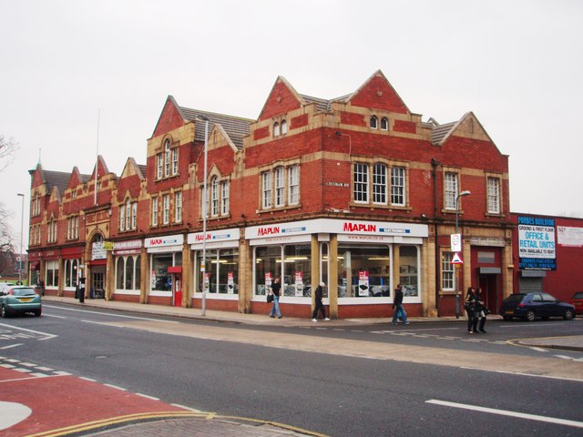
| Nos. 36-42, Linthorpe Road | 1139851 | II | 1889 | Central | Linthorpe Road |
| No. 7, Zetland Road | 1139851 | II* | 1881 | Central | Webb House |
| Boundary Wall at Entrance to Davy Offshore Modules Ltd. | 1312365 | II | 1887 | Central | |
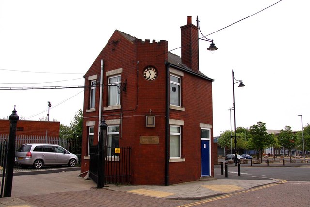
| Bridgekeepers House | 1139848 | II | 1911 | Central | At the entrance to the Transporter Bridge. |
| Captain Cook Public House | 1136730 | II | 1893 | Central | Former public house, Durham St. |
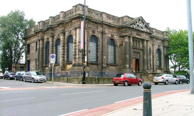
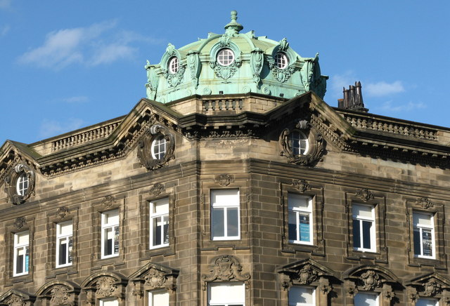
| Central Public Library | 1139838 | II | 1912 | Central | Victoria Square |
| Church House | 1137035 | II | 1879 | Central | Vicarage, Martan Road |
| Church of All Saints | 1252480 | II* | 1878 | Central | |
| Church of St Columba | 1139865 | II | 1902 | Central | |
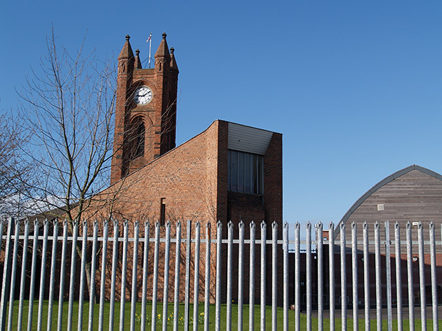
| Church of St John the Evangelist | 1139854 | II* | 1865 | Central | Boho 4 |
| Cleveland Buildings | 1312710 | II | c.1835 | Central (Middlehaven) | Cleveland Street |
| Cleveland Club, Area Walls, Piers and Railings | 1139868 | II | 1872 | Central | |
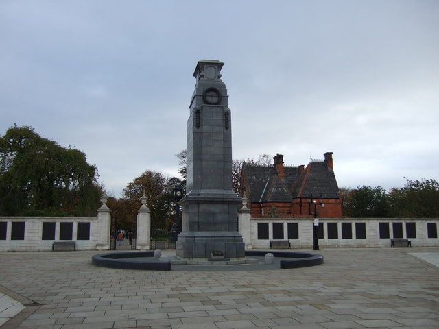
| Clock Tower, C5m South-West of Old Town Hall | 1312502 | II | 1846 | Central | By the Old Town Hall |
| Commerce House | 1329507 | II | 1872 | Central | Exchange Square |
| Constantine Building, University of Teesside | 1139864 | II | 1930 | Central | |
| Customs House | 1139855 | II | 1836 | Central (Middlehaven) | Now 'Myplace' |
| Darlington Building Society | 1136683 | II | 1913 | Central | Corporation Road |
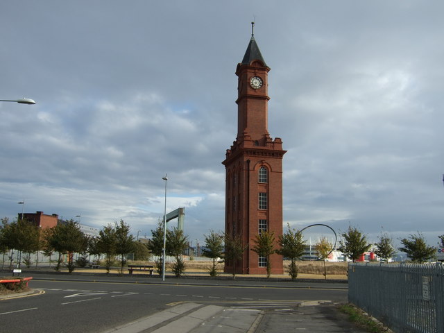
| Dock Clock Tower | 1139871 | II* | c.1870 | Central (Middlehaven) | |
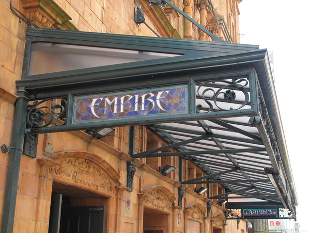
| Empire Mecca Social Club | 1329519 | II* | 1897 | Central | The Middlesbrough Empire |
| Exchange House | 1139843 | II | 1879 | Central | Exchange Square |
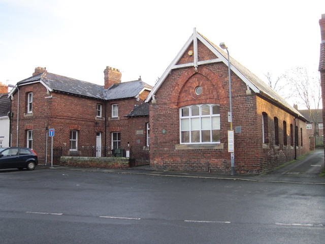
| Former Primary Infant School | 1380273 | II | 1892 | Central | Victoria Road |
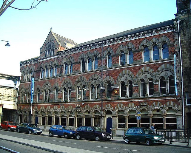
| Gates, Gatepiers and Boundary/Retaining Walls to Railway Station Forecourt, Including Commercial Premises | 1312321 | II | 1877 | Central | Zetland Road/Exchange Place |
| Gates, Gatepiers and Flanking Walls at Entrance to Nazareth House | 1329537 | II | 1905 | Central | Park Road North |
| Group of 5 Telephone Kiosks on East Side of Town Hall | 1139869 | II | C20th | Central | 5 red K6 type phoneboxes |
| Lloyds Bank Chambers | 1329516 | II | 1899 | Central | Albert Road |
| Midland Bank | 1139852 | II | 1912 | Central | Linthorpe Road |
| Midland Bank (Commerce House) | 1329520 | II | 1903 | Central | Exchange Place |
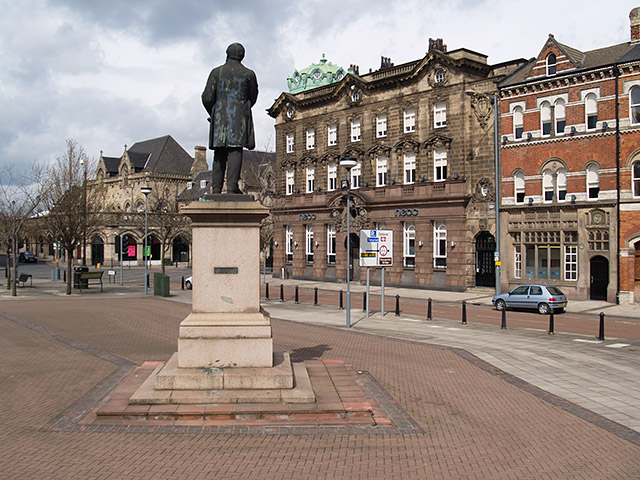
| Monument to H.W.F.Bolckow | 1139844 | II | 1881 | Central | Exchange Square |
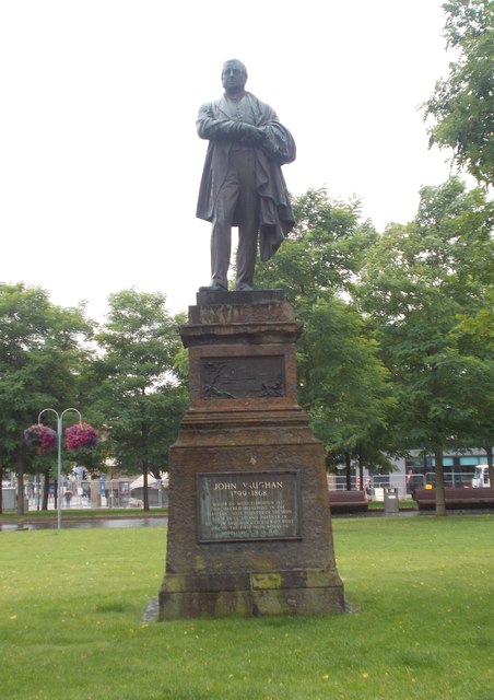
| Monument to John Vaughan | 1329504 | II | 1884 | Central | Victoria Square |
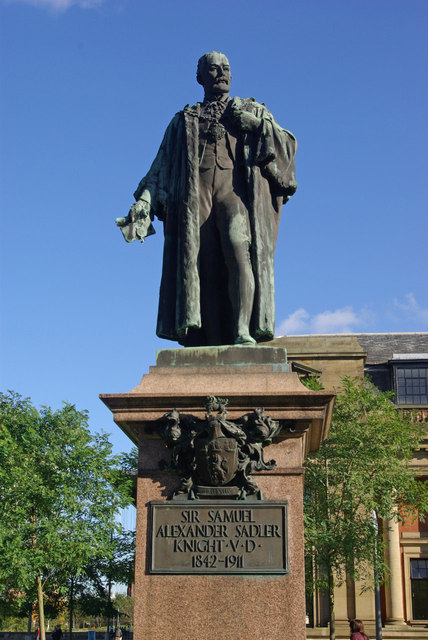
| Monument to Sir Samuel Sadler | 1137342 | II | 1913 | Central | Victoria Square |
| Nazareth House | 1139829 | II | 1906 | Central | Park Road North |
| New Exchange Buildings | 1139830 | II | 1874 | Central | Queen's Square |
| Nos. 2, 2a, 4 and Zetland Buildings | 1139842 | II | 1872 | Central | Exchange Place/Zetland Place |
| Old High School, University of Teesside | 1139863 | II | 1877 | Central | |
| Old Town Hall | 1139853 | II | 1846 | Central (Middlehaven) | East Street |
| Piers, Railings and Gates at Entrance to Transporter Bridge | 1139846 | II | 1910 | Central | |
| Queens Square - Nos. 1 to 15 odd | 1139831 | II | c.1850 | Central | |
| Queen's Square - Nos. 17 to 27 odd | 1329538 | II | 1899 | Central | |
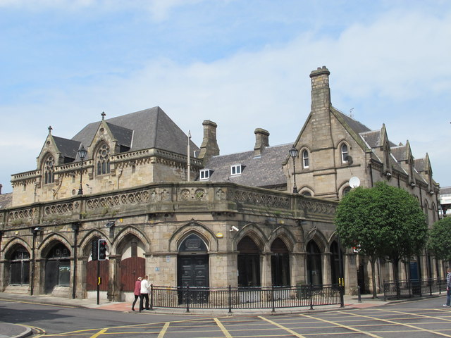
| Railway Station with Shops, Offices and Two Bridges | 1139840 | II | 1877 | Central | Middlesbrough Station, including Albert Bridge |
| Showboat Social Club | 1137368 | II | 1908 | Central | Wilson Street |
| South African War Memorial, in Albert Park | 1329536 | II | 1904 | Central | |
| Sundial, in Albert Park | 1139828 | II | 1879 | Central | |
| The Albert | 1329517 | II | 1901 | Central | 38 & 40, Albert Road |
| The Masham Hotel | 1312556 | II | 1914 | Central | Linthorpe Road |
| The Shakespeare | 1136953 | II | C19th | Central | Linthorpe Road |
| Town Hall and Municipal Buildings | 1136659 | II* | 1889 | Central | |
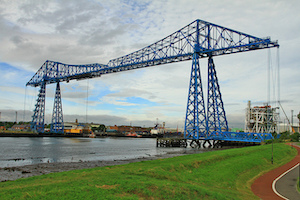
| Transporter Bridge | 1139845 | II* | 1911 | Central (Middlehaven) | Connects Middlesbrough & Port Clarence. |
| Trustee Saving Bank | 1139861 | II | 1905 | Central | Albert Road |
| Winch House, Adjoining Railings, Wall, Gates and Gatepiers, C.40m South West of Transporter Bridge | 1139847 | II | 1911 | Central | |
| York House | 1329518 | II | 1938 | Central | Borough Road |
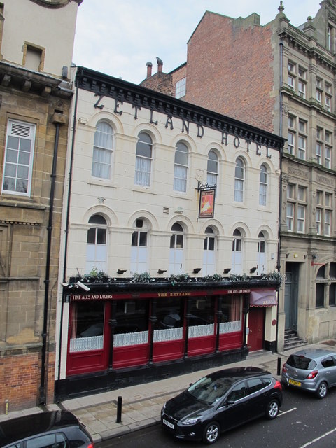
| Zetland Hotel | 1139839 | II | 1860 | Central | |
| Acklam Hall | 1136868 | I | 1680 | Acklam | |
| Coulby Manor | 1139870 | II | 1825 | Coulby Newham | |
| Walls Enclosing Carpark, C30m South-West of Coulby Manor | 1312659 | II | c.1825 | Coulby Newham | |
| Hemlington Hall Farmhouse, Farm Cottage and Garden Wall | 1137057 | II | C18th | Hemlington | |
| Stable and Cart Shed, Circa 20 Metres East of Hemlington Hall Farmhouse | 1329513 | II | C19th | Hemlington | |
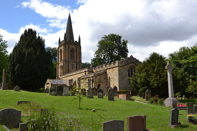
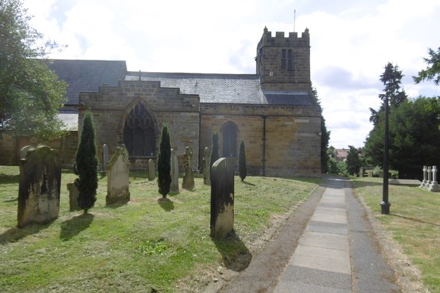
| Church of St. Cuthbert | 1329502 | II* | C12th | Marton East | Largely rebuilt in the 1840's |
| Armstrong/Ingledew Fenison Tombstone, C10m East of Church of St. Cuthbert armstrong/Ingledew Fenison Tombstone, Circa 10 Metres East of Church of St Cuthbert | 1137271 | II | 1812 | Marton East | Church of St. Cuthbert |
| Bolckow Tombstones, Grave Cover and Kerb, Circa 24 Metres East of Chancel of Church of St Cuthbert | 1139835 | II | 1858 | Marton East | 1858 to 1890 Church of St. Cuthbert |
| Captain Cook School and School House | 1329508 | II | 1850 | Marton East | |
| Coach House, Stable and Screen Wall Circa 10 Metres North East of Westside House | 1137262 | II | C19th | Marton East | |
| Davison Tombstone Circa 6 Metres South of South Trancept of Church of St Cuthbert | 1252527 | II | 1795 | Marton East | Church of St. Cuthbert |
| Davison Tombstone, Circa 5 Metres South of South Transept of Church of St Cuthbert | 1329503 | II | 1780 | Marton East | Church of St. Cuthbert |
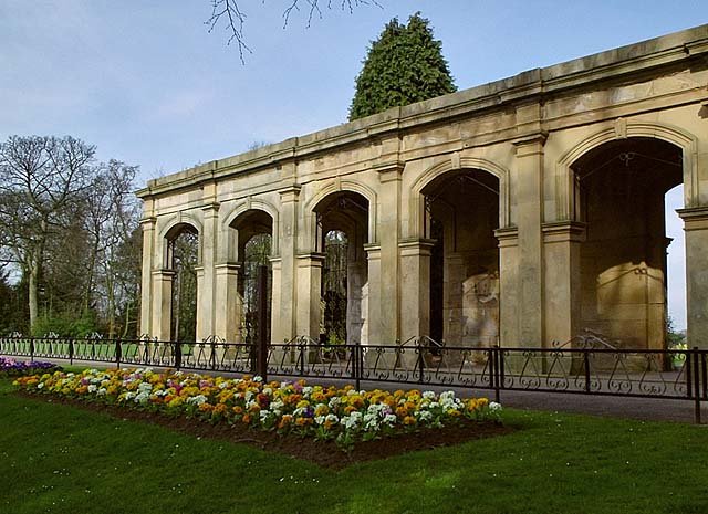
| Loggia Circa 20 Metres South of Captain Cook Birthplace Museum | 1139833 | II | 1860 | Marton East | In the former grounds of Marton Hall |
| Memorial to Captain James Cook Circa 80 Metres South of Captain Cook Birthplace Museum | 1137243 | II | 1858 | Marton East | |
| Stewart Park Depot | 1329539 | II | 1864 | Marton East | Former stable block to Martan Hall |
| Temple Circa 150 Metres South West of Captain Cook Birthplace Museum | 1312423 | II | c.1860 | Marton East | |
| Westside House | 1139834 | II | 1847 | Marton East | Former vicarage |
| Wright Tombstone, Circa 4 Metres South of South Porch of Church of St Cuthbert | 1137287 | II | 1750 | Marton East | Church of St. Cuthbert |
| Barn and Stable, 15m. East of Gunnergate Farmhouse | 1139849 | II | C18th | Marton West | |
| Barn, Horse-Mill, Stable and Cartshed, C.10m North-West of Bonny Grove Farmhouse | 1139866 | II | C18th | Marton West | |
| Bonny Grove Farmhouse | 1136565 | II | C18th | Marton West | |
| Gate, Gatepiers and Walls at Entrance to Newham Hall | 1136620 | II | 1880 | Marton West | |
| Gunnergate Farmhouse and Farm Cottage | 1136844 | II | C18th | Marton West | |
| Newham Hall Lodge | 1139867 | II | 1880 | Marton West | |
| Newham Hall, Retaining Wall and Steps | 1136584 | II | 1880 | Marton West | |
| Forbes' Buildings | 1312528 | II | 1900 | Newport | Linthorpe Road |
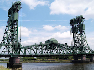
| Newport Bridge | 1139837 | II | 1934 | Newport | |
| Park Methodist Church | 1329511 | II | 1905 | Newport | Linthorpe Road |
| Phoenix Squash and Leisure Centre | 1329512 | II | 1902 | Newport | Former church |
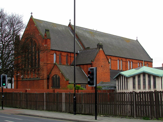
| Church of the Holy Trinity | 1139850 | II | 1881 | North Ormesby | |
| No. 1, East Side | 1139808 | II | c.1800 | Nunthorpe | |
| No. 4, West Side | 1137477 | II | C18th | Nunthorpe | |
| No. 6, West Side | 1329529 | II | 1840 | Nunthorpe | |
| Nos. 8 and 10, West Side | 1137492 | II | c.1800 | Nunthorpe | |
| Chapel of St. Mary, in Grounds of Nunthorpe Hall | 1329527 | II | 1824 | Nunthorpe | |
| Church of St. Mary | 1139841 | II | 1926 | Nunthorpe | |
| Garden Terrace Wall, Stairs and Steps, in Grounds of Nunthorpe Hall | 1329526 | II | C17th | Nunthorpe | |
| Gatepiers at Entrance to the Lodge and Poole Hospital | 1329528 | II | 1896 | Nunthorpe | |
| Gates, Gatepiers and Crescent Walls at Entrance to Nunthorpe Hall | 1139810 | II | 1901 | Nunthorpe | |
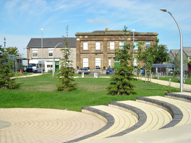
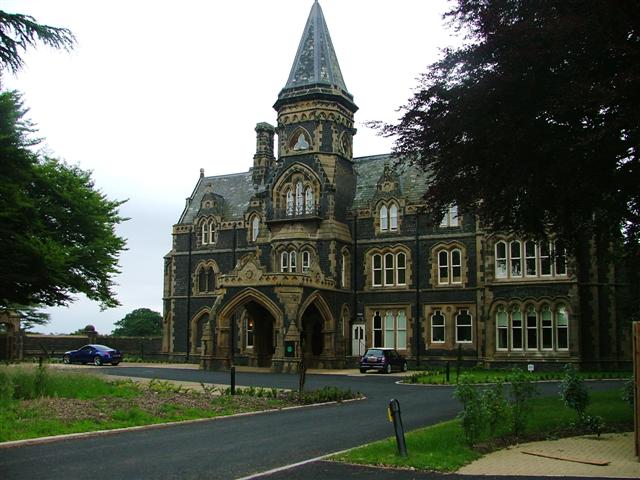
| Grey Towers House (Poole Hospital) and Attached Wall | 1139813 | II* | 1867 | Nunthorpe | |
| Lychgate and Adjoining Stile, Fence and Gate, C45m South-West of Church of St Mary | 1329525 | II | 1947 | Nunthorpe | War memorial |
| Nunthorpe Hall | 1139809 | II | 1623 | Nunthorpe | |
| Nunthorpe War Memorial | 1448373 | II | 1921 | Nunthorpe | |
| The Lodge | 1139812 | II | 1896 | Nunthorpe | Lodge to Grey Towers |
| The Vicarage | 1329506 | II | 1903 | Nunthorpe | Former schoolmaster's house |
| Tree Bridge | 1139811 | II | C19th | Nunthorpe | |
| Nos. 33-55, High Street | 1329509 | II | C18th | Park End & Beckfield | Terrace of 13 almshouses and school |
| Nos. 57-61, High Street | 1136930 | II | C18th | Park End & Beckfield | Terrace of 3 almshouses |
| Avenue Methodist Church | 1139862 | II | 1908 | Park (Linthorpe) | |
| Cenotaph, with Memorial Gates, Gatepiers and Screen Walls | 1137094 | II | 1922 | Park (Linthorpe) | By Albert Park |
| Church of St. Barnabas | 1139832 | II | 1892 | Park (Linthorpe) | |
| Church of the Sacred Heart | 1329510 | II | 1932 | Park (Linthorpe) | |
| Coffin in Grounds of Dorman Memorial Museum | 1139856 | II | Roman | Park (Linthorpe) | |
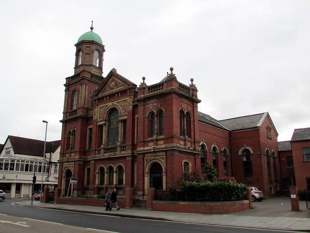
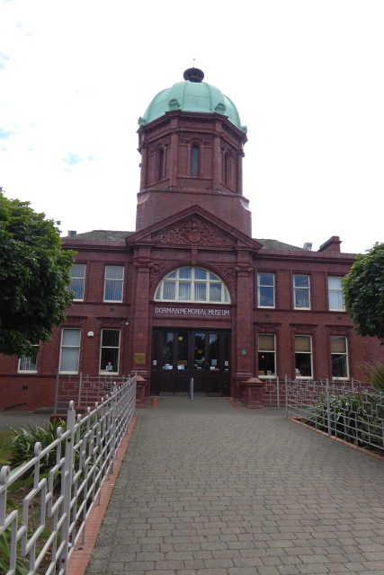
| Dorman Memorial Museum | 1137086 | II | 1904 | Park (Linthorpe) | |
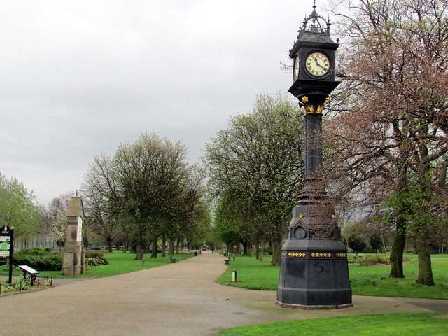
| Memorial Clock, in Albert Park | 1139827 | II | c.1900 | Park (Linthorpe) | Albert Park |
| West Lodge and Attached Screen Wall and Memorial in Albert Park | 1329535 | II | 1866 | Park (Linthorpe) | Albert Park |
| Boundary Wall, Gates and Gatepiers of Church of St. Peter and St. Paul | 1139817 | II | C17th | Stainton & Thornton | |
| Burdon Table Tomb, 4m East of Chancel of Church of St. Peter and St. Paul | 1329532 | II | 1741 | Stainton & Thornton | 1741 to 1821 |
| Church of St. Peter and St. Paul | 1137540 | II* | C13th | Stainton & Thornton | largely rebuilt c.1800 |
| Church View | 1139814 | II | c.1800 | Stainton & Thornton | |
| Coffin, One M.south of Chancel of Church of St. Peter and St. Paul | 1137556 | II | Stainton & Thornton | Prob. Anglo-Saxon | |
| Corney (Or Corner) Tombstone, 7m. West of Church of St. Peter and St. Paul | 1137559 | II | C17th | Stainton & Thornton | |
| Low Farmhouse 2 Farm Cottages and Adjoining Outbuildings | 1137568 | II | c.1800 | Stainton & Thornton | |
| Memorial Hall | 1329530 | II | 1844 | Stainton & Thornton | Former National School |
| Pair of Dovecotes and Linking Outhouse, C.20m North-West of Stainton Vale Farmhouse | 1139815 | II | C19th | Stainton & Thornton | |
| Rennison Tombstone, 3m South of Chancel of Church of St. Peter and St. Paul | 1139816 | II | 1722 | Stainton & Thornton | |
| Stainton Grange and Garden Walls | 1329531 | II* | C18th | Stainton & Thornton | |
| Stainton House | 1137500 | II | C18th | Stainton & Thornton | Former vicarage |
| Stainton Vale Farmhouse | 1312282 | II | C18th | Stainton & Thornton | |
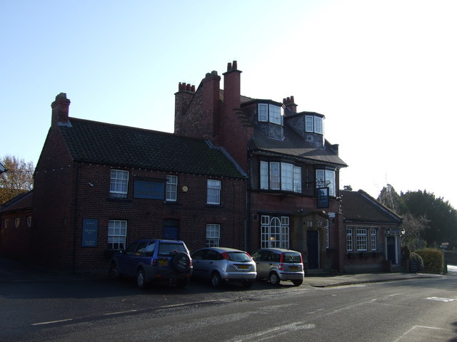
| The Stainton Public House | 1137526 | II | 1897 | Stainton & Thornton | |
| Walls, Gates and Gatepiers to Garden of No 15 | 1329533 | II | C18th | Stainton & Thornton | |
| Earthworks at Nunthorpe Hall | 1006762 | n/a | C12th? | Nunthorpe | Scheduled Monument |
| Fishpond 550m east of Acklam Park | 1018944 | n/a | Medieval | Park (Linthorpe) | Scheduled Monument (now dry) |
| Stainsby medieval village and open field system | 1016352 | n/a | Medieval | Scheduled Monument | |
| Albert Park | 1000646 | II | 1868 | Park (Linthorpe) | Listed Park and Garden |
| Britannia Testing House, Riverside Park | - | Local | 1926 | Middlehaven | Former Dorman Long ltd |
| Middlehaven Public House, Stockton Street | - | Local | 1831 | Middlehaven | Damaged by fire in 2012 |
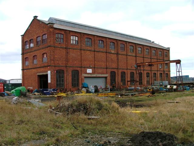
| Locomotive Shed (Bolckow and Vaughan’s Ironworks) | - | Local | c.1880 | Middlehaven | |
| Storrow’s Building, Dock Street | - | Local | 1860 | Middlehaven | |
| Middlesbrough Dock | - | Local | 1842 | Middlehaven | |
| Bridge Inn Public House, Bridge Street East | - | Local | 1858 | Middlehaven | |
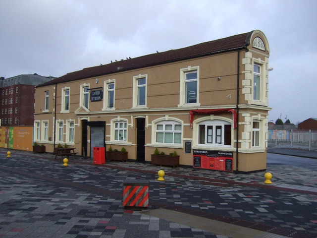
| Lord Byron Public House, Bridge Street East | - | Local | 1864 | Middlehaven | |
| Warehouse, School Croft | - | Local | c.1900 | Middlehaven | |
| Navigation Inn, Cargo Fleet Lane | - | Local | c.1880 | Middlehaven | |
| Isaac Wilson Public House, 65 Wilson Street | - | Local | 1901 | Middlehaven | |
| Wellington Hotel & 9 Albert Road | - | Local | 1891 | Middlehaven | |
| Nos. 13-25 Albert Road | - | Local | c.1900 | Middlehaven | |
| Nos. 42 Albert Road (Former National Westminster Bank) | - | Local | 1938 | Middlehaven | |
| The Princess Alice Public House, 67-69 Newport Road | - | Local | c.1866 | Middlehaven | |
| Debenhams, 1 Newport Road | - | Local | 1910 | Middlehaven | |
| Miss Selfridge, 64-66 Linthorpe Road | - | Local | 1898 | Middlehaven | |
| William Hill, 17 Corporation Road | - | Local | c.1890 | Middlehaven | |
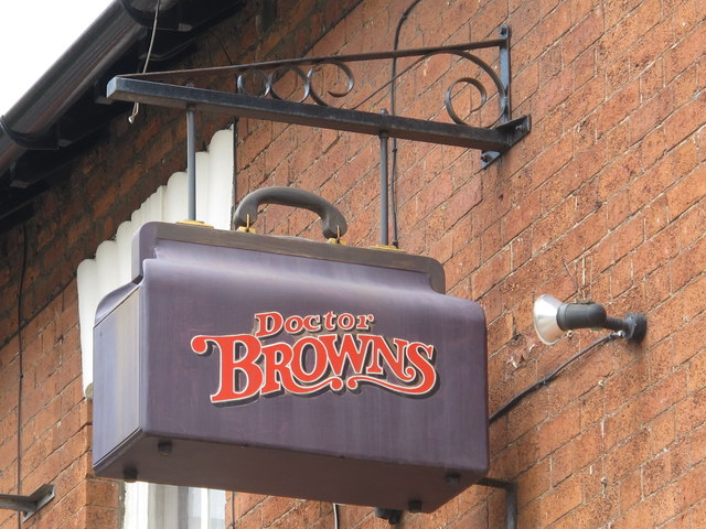
| Doctor Brown’s Public House and adjoining terrace, 97 Marton Road | - | Local | 1862 | Middlehaven | |
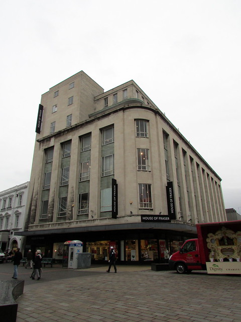
| House of Fraser, 37 Linthorpe Road | - | Local | 1957 | Middlehaven | |
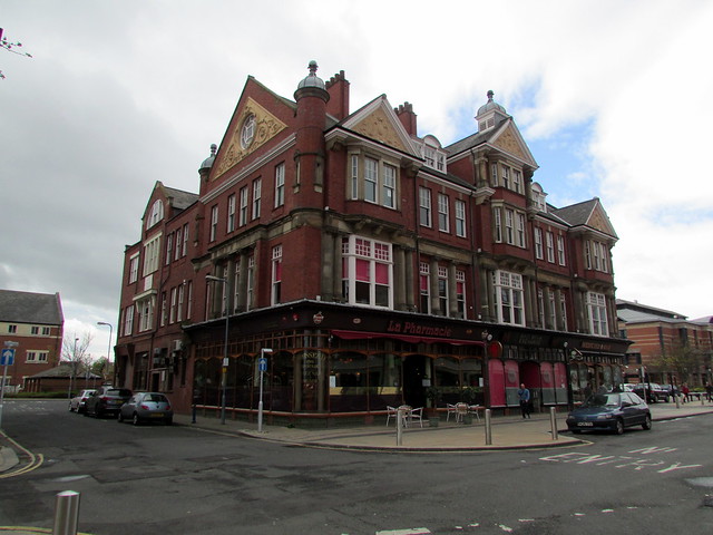
| Multi Media Centre, Medicine Bar and La Pharmacie, 89-90 Corporation Road | - | Local | 1898 | Middlehaven | originally for Middlesbrough Co-operative Society |
| St Mary’s Centre, 82-90 Corporation Road | - | Local | 1881 | Middlehaven | |
| The Green Tree Public House, Gilkes Street | - | Local | C19th | Middlehaven | |
| Peel Engravers and adjoining terrace, Gilkes Street | - | Local | c.1870 | Middlehaven | |
| Methodist Church & Sunday School, 126-132 Linthorpe Road | - | Local | 1892 | Middlehaven | |
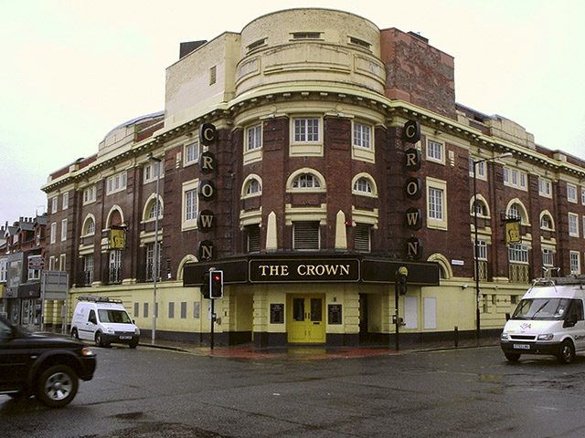
| The Crown Public House 51-53 Borough Road | - | Local | 1923 | Middlehaven | |
| Former Southbrooke Girls School, 154 Borough Road | - | Local | 1882 | Middlehaven | |
| King Edward’s Square, University of Teesside | - | Local | c.1890 | Middlehaven | |
| Gazette Offices, Borough Road | - | Local | 1938 | Middlehaven | |
| Psyche, 175-187 Linthorpe Road | - | Local | 1950s | Middlehaven | |
| TS: One Public House, 200 Linthorpe Road | - | Local | 1926 | Middlehaven | |
| Christadelphian Hall, Southfield Road | - | Local | 1937 | Middlehaven | |
| The Roseberry Public House, Acklam Road | - | Local | 1934 | Ayresome | |
| Whinney Banks School, Fakenham Avenue | - | Local | 1938 | Ayresome | |
| St Francis RC Church, Acklam Road | - | Local | 1933 | Ayresome | |
| Samuelson’s Working Men’s Club, Parliament Road | - | Local | 1904 | Gresham | |
| The Cooperative Building, 251-255 Linthorpe Road | - | Local | 1941 | Gresham | |
| St Aidan’s Church, Clifton Street | - | Local | 1940 | Gresham | |
| University Sports Centre (former Methodist Church) University of Teesside, Laura Street | - | Local | 1908 | University | |
| Mosque and Community Centre, 133a Waterloo Road | - | Local | 1900 | University | |
| No. 34 Park Road North | - | Local | 1879 | University | |
| Nos. 214 –216 Marton Road | - | Local | c.1875 | University | |
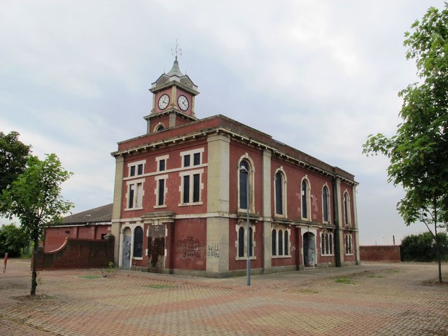
| North Ormesby Youth and Community Centre, Derwent Street | - | Local | 1875 | North Ormesby | |
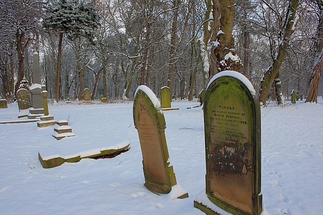
| Linthorpe Cemetery | - | Local | 1869 | Linthorpe | Incl. Quaker burial ground, dating of 1668. |
| Linthorpe Community Primary School | - | Local | 1874 | Linthorpe | |
| No. 51 Cambridge Road | - | Local | c.1910 | Linthorpe | |
| Nos. 5-19 Claude Avenue | - | Local | c.1899 | Linthorpe | |
| No. 110 The Avenue, Linthorpe | - | Local | c.1860 | Linthorpe | |
| East Lodge, Albert Park | - | Local | 1867 | Park | |
| Nos. 353-359 Linthorpe Road (opposite Dorman Museum) | - | Local | c.1890 | Park | |
| United Reform Church, Linthorpe Road | - | Local | 1924 | Park | |
| Albert Park Public House, 406 Linthorpe Road | - | Local | c.1868 | Park | |
| The Cleveland Hotel, Linthorpe Road | - | Local | 1857 | Park | |
| Linthorpe Hotel, The Crescent | - | Local | ? | Park | |
| Kirby College, Roman Road | - | Local | 1911 | Park | |
| Holmwood, Orchard Road | - | Local | 1895 | Park | |
| Redlands Conservative Club, Orchard Road | - | Local | c.1870 | Park | |
| Roseberry and Park View, 274-276 Marton Road | - | Local | c.1875 | Claireville | |
| St. Joseph’s RC Church, Marton Road | - | Local | 1934 | Claireville | |
| Holy Name of Mary RC Church, The Avenue, Linthorpe | - | Local | 1938 | Claireville | |
| Former Sacred Heart Home & Presbytery to Holy Name RC Church | - | Local | c.1900 | Claireville | |
| Blue Bell Hotel, Acklam Road | - | Local | 1939 | Kader | |
| Slip Inn Bridge, Ladgate Lane | - | Local | C18th | Kader | |
| St Mary’s Church, Church Lane | - | Local | 1874 | Acklam | |
| Danby House and Blacksmiths Forge, 321 Acklam Road | - | Local | 1878 | Acklam | |
| West Lodge, Acklam Road | - | Local | 1912 | Acklam | |
| Newham Bridge | - | Local | C18th | Acklam | |
| South Lodge, Acklam Road | - | Local | 1912 | Acklam | |
| Nos. 88-90 The Grove | - | Local | c.1910 | Marton | |
| East Lodge, 76 The Grove | - | Local | c.1860 | Marton | |
| Nos. 83-85 The Grove | - | Local | c.1907 | Marton | |
| Stewart Park | - | Local | 1923 | Marton | |
| West Lodge, Marton Hall, Stokesley Road | - | Local | c.1860 | Marton | |
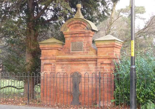
| Drinking Fountain, Stokesley Road | - | Local | 1879 | Marton | |
| Westside, Marton | - | Local | c.1880 | Marton | |
| The Fountain Inn, Ormesby High Street | - | Local | 1958 | Beckfield | |
| Eastleigh and Westleigh, Ormesby High Street | - | Local | 1876 | Beckfield | |
| Methodist Chapel, Meldyke Lane, Stainton | - | Local | 1840 | Stainton & Thornton | |
| Stainton School, 6-8 Meldyke Lane, Stainton | - | Local | 1876 | Stainton & Thornton | |
| No. 14 Hemlington Road, Stainton | - | Local | c.1800 | Stainton & Thornton | |
| No. 1 Thornton Road, and 2-8 Maltby Road, Thornton | - | Local | c.1930 | Stainton & Thornton | |
| Newham Grange Farm | - | Local | 1786 | Coulby Newham | |
| Newham Hall Farm | - | Local | C19th | Coulby Newham | |
| Lodges, 84 Gunnergate Lane & 21 Tollesby Lane | - | Local | 1857 | Marton West | |
| Hall Farm, East Side, Nunthorpe Village | - | Local | C19th | Nunthorpe | |
| Nunthorpe Station | - | Local | 1853 | Nunthorpe | |
| No. 123 Guisborough Road | - | Local | c.1910 | Nunthorpe | |
| Red Cottage, 135 Guisborough Road | - | Local | c.1910 | Nunthorpe | |
| Tudor Court, Church Lane | - | Local | c.1930 | Nunthorpe | |
| The Old School, Church Lane, Nunthorpe | - | Local | 1903 | Nunthorpe | |
| The Old Smithy, West Side, Nunthorpe | - | Local | c.1880 | Nunthorpe | |
| Nos. 14-16 Rookwood Road | - | Local | c.1920 | Nunthorpe |
1. Primary source: the National Heritage List for England - NHLE is the register of nationally protected historic buildings and sites in England, including listed buildings, scheduled monuments, protected wrecks, registered parks and gardens, and battlefields. The list is maintained by Historic England. Check NHLE for updates and new entries.
Secondary sources: British Listed Buildings and Middlesbrough Borough Council.
2. Middlesbrough's Local List Local list of buildings, structures, parks, gardens and open spaces of special local architectural or historic interest in Middlesbrough - Middlesbrough Borough Council (April 2011). Check Middlesbrough Council for updates and new entries.
Co-Curate Page
Acklam Hall
- Overview About Acklam Hall Map Street View Acklam Hall was built by William Hustler in 1678 in the former village, and now suburb, of Acklam in Middlesbrough. The mansion was …
Co-Curate Page
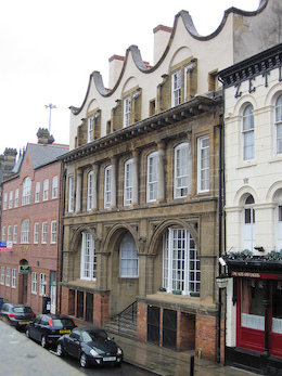
Webb House, 7 Zetland Road
- Overview Street View No. 7, Zetland Road, Middlesbrough, was constructed for ironmasters Bell Brothers between 1881 and 1891. It was the only commercial building ever designed by Philip Webb, the …
Co-Curate Page
All Saints Church
- Overview Map Street View All Saints Church is located on the corner of Grange Road and Linthorpe Road in Middlesbrough. The church was built 1873 - 1878, designed by G.E. Street. …
Co-Curate Page
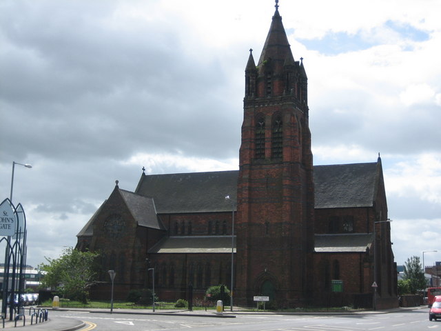
Church of St John the Evangelist
- Overview Timeline Map Street View The Church of St John the Evangelist is located by the junction of Marton Road and North Ormesby Road in Middlesbrough. The church was built …
Co-Curate Page
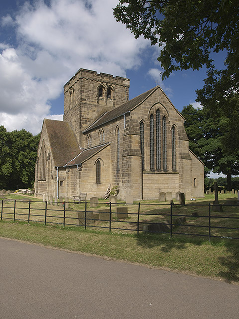
Church of St. Cuthbert, Ormesby
- Overview Map Street View St. Cuthbert's is the parish church in Ormesby, Middlesbrough. The church was largely rebuilt in 1875 by Hicks and Charlewood, but incorporates masonry from an earlier …
Co-Curate Page
Dock Clock Tower
- Overview Street View The current clock tower was built at the turn of the century (some time between 1870 and 1903) as Middlesbrough's docks were redeveloped. It replaced an earlier …
Co-Curate Page
Empire Mecca Social Club
- "Built in 1897 as a music hall The Middlesbrough Empire has played host to a variety of performers including Charlie Chaplin, Laurel & Hardy, The Scissor Sisters, The Arctic Monkeys …
Co-Curate Page
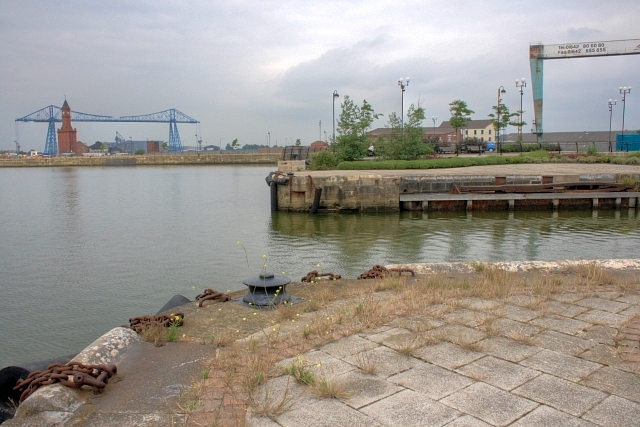
Tees Transporter Bridge
- Overview History Facts & Figures Map Street View The Tees Transporter Bridge was opened on the 17th October 1911 by Prince Arthur of Connaught. The bridge over the River Tees connects Middlesbrough, on the south bank, …
Co-Curate Page
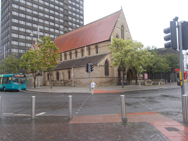
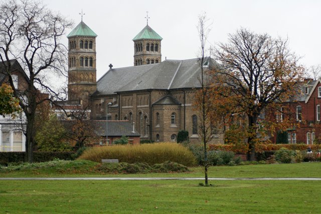
Church of the Holy Trinity, North Ormesby
- Overview Map Street View Holy Trinity Church in North Ormesby was built from 1868-1869, designed by William White in the Early English style. The tower, which is a prominent local …
Co-Curate Page
Cleveland Club
- Overview Map Street View Boho 4, former Cleveland Club is located on the corner of Gosford Street and Cleveland Street, Middlesbrough. It was originally built 1870 - 1872 by John …

Co-Curate Page
Constantine Building
- Overview Map Street View Constantine Building, Teesside University 93 Borough Rd
Co-Curate Page
Customs House
- Overview Map Street View The Customs House is located on North Street, Middlsbrough. It was originally built in 1836 as a Coal Exchange and hotel, designed by G. Burlison. It …
Co-Curate Page
29-31, Corporation Road
- Overview Map Street View Located on the corner of Corporation Road and Albert Road in Middlesbrough, the building was originally built as a shop and hotel in 1912-1913. It was …
Co-Curate Page
Forbes Building
- Overview Map Street View The Forbes' Buildings, nos. 311-321 Linthorpe Road in Middlesbrough were built 1899 -1900 by R. Lofthouse & Sons (Middlesbrough), for John Forbes.[1] It was originally a bakery with …
Co-Curate Page
Loggia of Marton Hall, Stewart Park
- Overview Map Street View The Loggia (a long sheltered gallery or or corridor, which forms part of a house, typically with a side open to the garden) in Stewart Park …
Co-Curate Page
Tees Newport Bridge
- Overview History Map Street View The Tees Newport Bridge was the first large vertical lift bridge in Europe, and opened by Prince Albert (later King George VI) on 28 February, …
Co-Curate Page
Old Town Hall
- Overview Map Street View The Old Town Hall is located on East Street in Middlsbrough. It was built in 1846, designed by W.L. Moffat.[1] It was replaced by the new …
Co-Curate Page
Park Methodist Church
- Overview Map Street View The former Park Methodist Church is located on the corner of Linthorpe Road and Ayresome Street, near Albert Park in Middlesbrough. The Wesleyan church was built 1903 - …
Co-Curate Page
Zetland Hotel
- The Zetland Hotel is a Grade 2 Listed Building which was built c.1860 and located on Zetland Road, close to Middlesbrough Station. Threatened with closure as a pub in 2015. …
Co-Curate Page
Dorman Museum
- Overview About the Museum Map Street View "The museum was officially opened on the 1st of July 1904, by the Colonel in Chief of the Yorkshire Regiment, as the Dorman …
Co-Curate Page
Middlesbrough Railway Station
- Overview About Middlesbrough Station Map Street View "On the 1st of December, 1877, the large fine station at Middlesbrough, which had been for some years in course of construction, was …
Co-Curate Page
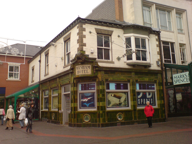
Masham Hotel
- Overview Map Street View Former hotel and pub on Linthorpe Road in the centre of Middlesbrough - now a shop. It was built in the mid 19th centry and has …
Co-Curate Page
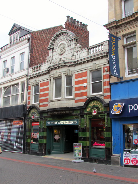
The Shakespeare
- Overview Map Street View The Shakespeare is a former public house on Linthorpe Road in Middlesbrough, built in the mid 19th century. It has a distinctive 1911 frontage by Kitching …
Co-Curate Page
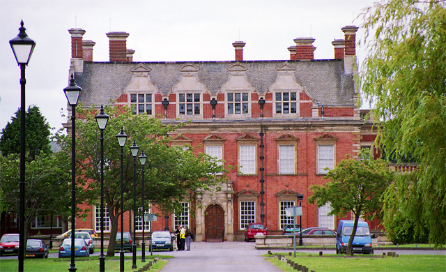
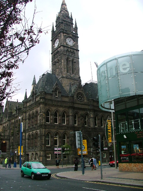
Middlesbrough Town Hall
- Overview About the Town Hall Map Street View The gothic style Town Hall and Municipal Buildings on Albert Road & Corporation Road in Middlesbrough were built between 1883-1889, and replaced …
Co-Curate Page
72-80 Corporation Road
- Overview Map Street View 72-80 Corporation Road, Middlesbrough was originally built in c.1898 as a shop, warehouse and offices for the Middlesbrough Co-operative Society. During the 1940’s and 1950’s the building …
Co-Curate Page
Danby House and Blacksmith’s Forge
- Overview Map Street View Danby House at 321 Acklam Road, is a former small holding and part of the former village of Acklam, before it became part of Middlesbrough. It …
Co-Curate Page
Dr Brown's, Corporation Road
- Overview Map Street View Doctor Brown's pub is located on the junction of Corporation Road and Marton Road in the centre of Middlesbrough. The triangular building was originally built as …
Co-Curate Page
Drinking Fountain, Stokesley Road, Marton
- Overview Map Street View Dated 1879 and located on Stokesley Road, opposite St Cuthbert’s Church, and at the south-west corner of Stewart Park in Marton. The drinking fountain was built …
Co-Curate Page
House of Fraser, 37 Linthorpe Road
- Overview Map Street View The House of Fraser Department Store (37 Linthorpe Road) is located in Middlesbrough town centre on the corner of Newport Road and Linthorpe Road. Built in …
Co-Curate Page
Linthorpe Cemetery
- Overview About Linthorpe Cemetery Map Street View Linthorpe cemetery is one of the oldest graveyards, in Middlesbrough, incorporating a Quaker burial ground, dating back to 1668. The cemetery covers of …
Co-Curate Page
Methodist Church, 126-132 Linthorpe Road
- Overview Map Street View Built as a Methodist Church and Sunday School in 1892, located on the corner of Linthorpe Road and Borough Road in Middlesbrough. Today the church still …
Co-Curate Page
Miss Selfridge, 64-66 Linthorpe Road
- Overview Map Street View Nos. 64-66 Linthorpe Road in Middlesbrough is a Miss Selfridge store on the corner of Linthorpe Road and Corporation Road. The building was originally built in …
Co-Curate Page
Old Stainton School
- Overview Map Street View Stainton Board Schools (separate boys and girls schools within the building) was constructed in 1876 by the Stainton, Thornton and Maltby School Board. It replaced the …
Co-Curate Page
The Crown
- Overview Map Street View The Crown is a prominent building on the corner of Linthorpe Road and Borough Road, Middlesbrough. The building was designed by architect James Forbes, and was …
Co-Curate Page
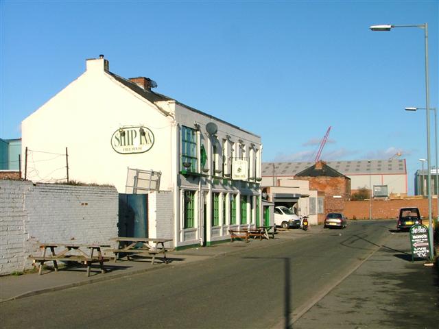
Middlehaven Public House, Stockton Street
- Overview Map Street View The Middlehaven was a public house on Stockton Street in the Middlehaven area of Middlesbrough. It was formerly called the Ship Inn, which was first licenced …
Co-Curate Page
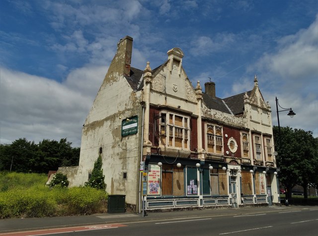
Captain Cook Pub, Durham St, Middlesbrough
- Overview Map Street View The Captain Cook was a public house on Durham Street in the Middlehaven area of Middlesbrough. The pub, named after Captain James Cook, designed in a …
Co-Curate Page
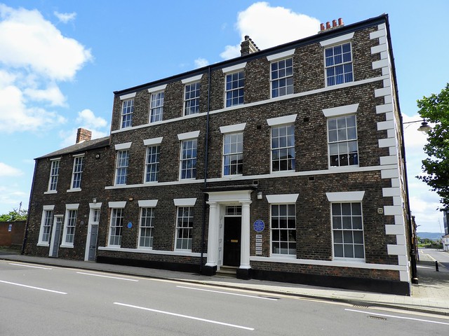
Cleveland Buildings, Middlesbrough
- Overview Map Street View The Cleveland Buildings are located on the corner of Cleveland Street and Lower Gosford Street, in the Middlehaven area of Middlesbrough. It was built as a …
Co-Curate Page
Middlesbrough War Memorial
- Overview Map Street View The Cenotaph at Middlesbrough is located at the west entrance to Albert Park. It was built in 1922 by Brierley and Rutherford (York), and Messrs Coxhead …
Co-Curate Page
Statue of Henry Bolckow, Exchange Square
- Overview Map Street View A statue of Henry Bolckow is located on Exchange Square in Middlesbrough. The statue, by D.W. Stevenson and Sir John Steell, depicts H.W.F. Bolckow holding the …
Co-Curate Page
Statue of John Vaughan
- Overview Map Street View A statue of John Vaughan stands in Centre Square, near the public library, in Middlesbrough. The statue, by G.A. Lawson, was erected in 1884 and was originally sited in …
Co-Curate Page
Statue of Samuel Sadler
- Overview Map Street View A statue of Sir Samuel Sadler stands on Centre Square in Middlesbrough. The statue, by Prof. Edward Lanteri, was erected in 1913. The statue is Grade II …
Co-Curate Page
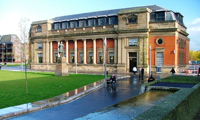
Central Public Library, Middlesbrough
- Overview Map Street View The Central Public Library is located on Centre Square in Middlesbrough. The building was designed by S.B. Russell and T.E. Cooper (London), and was part funded …
Co-Curate Page
Commerce House
- Overview Map Street View Commerce House is located on the corner of Exchange Square and Exchange Place in Middlesbrough. It was built 1901 - 1903, designed in a Baroque style, …
Co-Curate Page
2-4 Exchange Place
- Overview Map Street View 2,3 & 4 Exchange Place in Middlesbrough were built in c.1870 as offices by W.H. Blessley (Middlesbrough).[1] The building is adjacent to Albert Bridge, near Middlesbrough …
Co-Curate Page
Bridge Master's House, Middlesbrough
- Overview Map Street View The Bridgekeeper's house is located on Ferry Road, by the south entrance to the Tees Transporter Bridge in Middlesbrough. The red brick building was constructed in …
Co-Curate Page
Church of St Peter and St Paul, Stainton
- Overview Map Street View St Peter and St Paul's Church is located on Hemlington Road in Stainton. "There has probably been a Church serving the community in Stainton-in-Cleveland since the …
Co-Curate Page
Grey Towers
- Overview Map Street View Grey Towers is a large country house built 1865-1867 for William Hopkins, ironmaster and Mayor of Middlesbrough. It is faced with whinstone, which is unusual compared …
Co-Curate Page
Albert Park
- Summary About Albert Park Map "A public park designed by William Barratt of Wakefield and opened 11th August 1868, with war memorial entrance screen walls and a cenotaph of 1922...The idea …
Co-Curate Page
Church of St. Barnabas, Linthorpe
- Overview Map Street View St. Barnabas' Church is located on the junction of Linthorpe Road and St Barnabas Road, in the Linthorpe area of Middlesbrough. It was built 1888 - …
Co-Curate Page
Church of St. Mary, Nunthorpe
- Overview Map Street View The Church of St Mary is located to the east of Nunthorpe in Middlesbrough. It was built 1924-1926 by Temple Moore and Leslie Moore. St Mary's …
Co-Curate Page
Sacred Heart Church
- Overview About the Church Map Street View Sacred Heart Church is located on Linthorpe Road, by Albert Park, in Middlesbrough. The Catholic church, by J. Coomans (Ypres) and Kitching & …
Co-Curate Page
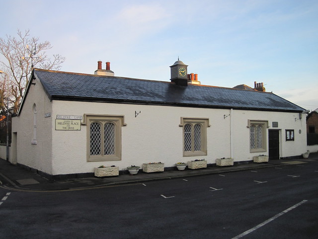
Memorial Hall, Stainton
- Overview Map Street View Memorial Hall is located on Meldyke Place in Stainton, Middlesbrough. The building has an interesting history; it was originally built in 1844 as a national school. …
Co-Curate Page
Nunthorpe Hall
- Overview Map Street View A large manor house, c.1623, located near the 'old village' of Nunthorpe. The hall was largely rebuilt and extended c.1800. It is a Grade II listed …
Co-Curate Page
The Stainton public house
- Overview Map Street View The Stainton Inn and Tea Rooms (aka'The Stainton') is located on Meldyke Lane in Stainton, Middlesbrough. Built in 1897, the pub is Grade II listed on …

Co-Curate Page
Zetland Buildings, Middlesbrough
- Zetland Buildings in Middlesbrough are offices, of c.1872, in 3 builds, in a Venician Gothic style by W.H. Blessley (Middlesbrough). They are a distinctive concave-curved terrace with right end convex-curved …

Co-Curate Page
Acklam Hall
- Overview About Acklam Hall Map Street View Acklam Hall was built by William Hustler in 1678 in the former village, and now suburb, of Acklam in Middlesbrough. The mansion was …
Co-Curate Page
Webb House, 7 Zetland Road
- Overview Street View No. 7, Zetland Road, Middlesbrough, was constructed for ironmasters Bell Brothers between 1881 and 1891. It was the only commercial building ever designed by Philip Webb, the …
Co-Curate Page
All Saints Church
- Overview Map Street View All Saints Church is located on the corner of Grange Road and Linthorpe Road in Middlesbrough. The church was built 1873 - 1878, designed by G.E. Street. …
Co-Curate Page
Church of St John the Evangelist
- Overview Timeline Map Street View The Church of St John the Evangelist is located by the junction of Marton Road and North Ormesby Road in Middlesbrough. The church was built …
Co-Curate Page
Church of St. Cuthbert, Ormesby
- Overview Map Street View St. Cuthbert's is the parish church in Ormesby, Middlesbrough. The church was largely rebuilt in 1875 by Hicks and Charlewood, but incorporates masonry from an earlier …
Co-Curate Page
Dock Clock Tower
- Overview Street View The current clock tower was built at the turn of the century (some time between 1870 and 1903) as Middlesbrough's docks were redeveloped. It replaced an earlier …
Co-Curate Page
Empire Mecca Social Club
- "Built in 1897 as a music hall The Middlesbrough Empire has played host to a variety of performers including Charlie Chaplin, Laurel & Hardy, The Scissor Sisters, The Arctic Monkeys …
Co-Curate Page
Tees Transporter Bridge
- Overview History Facts & Figures Map Street View The Tees Transporter Bridge was opened on the 17th October 1911 by Prince Arthur of Connaught. The bridge over the River Tees connects Middlesbrough, on the south bank, …
Co-Curate Page
Church of the Holy Trinity, North Ormesby
- Overview Map Street View Holy Trinity Church in North Ormesby was built from 1868-1869, designed by William White in the Early English style. The tower, which is a prominent local …
Co-Curate Page
Cleveland Club
- Overview Map Street View Boho 4, former Cleveland Club is located on the corner of Gosford Street and Cleveland Street, Middlesbrough. It was originally built 1870 - 1872 by John …
Co-Curate Page
Constantine Building
- Overview Map Street View Constantine Building, Teesside University 93 Borough Rd
Co-Curate Page
Customs House
- Overview Map Street View The Customs House is located on North Street, Middlsbrough. It was originally built in 1836 as a Coal Exchange and hotel, designed by G. Burlison. It …
Co-Curate Page
29-31, Corporation Road
- Overview Map Street View Located on the corner of Corporation Road and Albert Road in Middlesbrough, the building was originally built as a shop and hotel in 1912-1913. It was …
Co-Curate Page
Forbes Building
- Overview Map Street View The Forbes' Buildings, nos. 311-321 Linthorpe Road in Middlesbrough were built 1899 -1900 by R. Lofthouse & Sons (Middlesbrough), for John Forbes.[1] It was originally a bakery with …
Co-Curate Page
Loggia of Marton Hall, Stewart Park
- Overview Map Street View The Loggia (a long sheltered gallery or or corridor, which forms part of a house, typically with a side open to the garden) in Stewart Park …
Co-Curate Page
Tees Newport Bridge
- Overview History Map Street View The Tees Newport Bridge was the first large vertical lift bridge in Europe, and opened by Prince Albert (later King George VI) on 28 February, …
Co-Curate Page
Old Town Hall
- Overview Map Street View The Old Town Hall is located on East Street in Middlsbrough. It was built in 1846, designed by W.L. Moffat.[1] It was replaced by the new …
Co-Curate Page
Park Methodist Church
- Overview Map Street View The former Park Methodist Church is located on the corner of Linthorpe Road and Ayresome Street, near Albert Park in Middlesbrough. The Wesleyan church was built 1903 - …
Co-Curate Page
Zetland Hotel
- The Zetland Hotel is a Grade 2 Listed Building which was built c.1860 and located on Zetland Road, close to Middlesbrough Station. Threatened with closure as a pub in 2015. …
Co-Curate Page
Dorman Museum
- Overview About the Museum Map Street View "The museum was officially opened on the 1st of July 1904, by the Colonel in Chief of the Yorkshire Regiment, as the Dorman …
Co-Curate Page
Middlesbrough Railway Station
- Overview About Middlesbrough Station Map Street View "On the 1st of December, 1877, the large fine station at Middlesbrough, which had been for some years in course of construction, was …
Co-Curate Page
Masham Hotel
- Overview Map Street View Former hotel and pub on Linthorpe Road in the centre of Middlesbrough - now a shop. It was built in the mid 19th centry and has …
Co-Curate Page
The Shakespeare
- Overview Map Street View The Shakespeare is a former public house on Linthorpe Road in Middlesbrough, built in the mid 19th century. It has a distinctive 1911 frontage by Kitching …
Co-Curate Page
Middlesbrough Town Hall
- Overview About the Town Hall Map Street View The gothic style Town Hall and Municipal Buildings on Albert Road & Corporation Road in Middlesbrough were built between 1883-1889, and replaced …
Co-Curate Page
72-80 Corporation Road
- Overview Map Street View 72-80 Corporation Road, Middlesbrough was originally built in c.1898 as a shop, warehouse and offices for the Middlesbrough Co-operative Society. During the 1940’s and 1950’s the building …
Co-Curate Page
Danby House and Blacksmith’s Forge
- Overview Map Street View Danby House at 321 Acklam Road, is a former small holding and part of the former village of Acklam, before it became part of Middlesbrough. It …
Co-Curate Page
Dr Brown's, Corporation Road
- Overview Map Street View Doctor Brown's pub is located on the junction of Corporation Road and Marton Road in the centre of Middlesbrough. The triangular building was originally built as …
Co-Curate Page
Drinking Fountain, Stokesley Road, Marton
- Overview Map Street View Dated 1879 and located on Stokesley Road, opposite St Cuthbert’s Church, and at the south-west corner of Stewart Park in Marton. The drinking fountain was built …
Co-Curate Page
House of Fraser, 37 Linthorpe Road
- Overview Map Street View The House of Fraser Department Store (37 Linthorpe Road) is located in Middlesbrough town centre on the corner of Newport Road and Linthorpe Road. Built in …
Co-Curate Page
Linthorpe Cemetery
- Overview About Linthorpe Cemetery Map Street View Linthorpe cemetery is one of the oldest graveyards, in Middlesbrough, incorporating a Quaker burial ground, dating back to 1668. The cemetery covers of …
Co-Curate Page
Methodist Church, 126-132 Linthorpe Road
- Overview Map Street View Built as a Methodist Church and Sunday School in 1892, located on the corner of Linthorpe Road and Borough Road in Middlesbrough. Today the church still …
Co-Curate Page
Miss Selfridge, 64-66 Linthorpe Road
- Overview Map Street View Nos. 64-66 Linthorpe Road in Middlesbrough is a Miss Selfridge store on the corner of Linthorpe Road and Corporation Road. The building was originally built in …
Co-Curate Page
Old Stainton School
- Overview Map Street View Stainton Board Schools (separate boys and girls schools within the building) was constructed in 1876 by the Stainton, Thornton and Maltby School Board. It replaced the …
Co-Curate Page
The Crown
- Overview Map Street View The Crown is a prominent building on the corner of Linthorpe Road and Borough Road, Middlesbrough. The building was designed by architect James Forbes, and was …
Co-Curate Page
Middlehaven Public House, Stockton Street
- Overview Map Street View The Middlehaven was a public house on Stockton Street in the Middlehaven area of Middlesbrough. It was formerly called the Ship Inn, which was first licenced …
Co-Curate Page
Captain Cook Pub, Durham St, Middlesbrough
- Overview Map Street View The Captain Cook was a public house on Durham Street in the Middlehaven area of Middlesbrough. The pub, named after Captain James Cook, designed in a …
Co-Curate Page
Cleveland Buildings, Middlesbrough
- Overview Map Street View The Cleveland Buildings are located on the corner of Cleveland Street and Lower Gosford Street, in the Middlehaven area of Middlesbrough. It was built as a …
Co-Curate Page
Middlesbrough War Memorial
- Overview Map Street View The Cenotaph at Middlesbrough is located at the west entrance to Albert Park. It was built in 1922 by Brierley and Rutherford (York), and Messrs Coxhead …
Co-Curate Page
Statue of Henry Bolckow, Exchange Square
- Overview Map Street View A statue of Henry Bolckow is located on Exchange Square in Middlesbrough. The statue, by D.W. Stevenson and Sir John Steell, depicts H.W.F. Bolckow holding the …
Co-Curate Page
Statue of John Vaughan
- Overview Map Street View A statue of John Vaughan stands in Centre Square, near the public library, in Middlesbrough. The statue, by G.A. Lawson, was erected in 1884 and was originally sited in …
Co-Curate Page
Statue of Samuel Sadler
- Overview Map Street View A statue of Sir Samuel Sadler stands on Centre Square in Middlesbrough. The statue, by Prof. Edward Lanteri, was erected in 1913. The statue is Grade II …
Co-Curate Page
Central Public Library, Middlesbrough
- Overview Map Street View The Central Public Library is located on Centre Square in Middlesbrough. The building was designed by S.B. Russell and T.E. Cooper (London), and was part funded …
Co-Curate Page
Commerce House
- Overview Map Street View Commerce House is located on the corner of Exchange Square and Exchange Place in Middlesbrough. It was built 1901 - 1903, designed in a Baroque style, …
Co-Curate Page
2-4 Exchange Place
- Overview Map Street View 2,3 & 4 Exchange Place in Middlesbrough were built in c.1870 as offices by W.H. Blessley (Middlesbrough).[1] The building is adjacent to Albert Bridge, near Middlesbrough …
Co-Curate Page
Bridge Master's House, Middlesbrough
- Overview Map Street View The Bridgekeeper's house is located on Ferry Road, by the south entrance to the Tees Transporter Bridge in Middlesbrough. The red brick building was constructed in …
Co-Curate Page
Church of St Peter and St Paul, Stainton
- Overview Map Street View St Peter and St Paul's Church is located on Hemlington Road in Stainton. "There has probably been a Church serving the community in Stainton-in-Cleveland since the …
Co-Curate Page
Grey Towers
- Overview Map Street View Grey Towers is a large country house built 1865-1867 for William Hopkins, ironmaster and Mayor of Middlesbrough. It is faced with whinstone, which is unusual compared …
Co-Curate Page
Albert Park
- Summary About Albert Park Map "A public park designed by William Barratt of Wakefield and opened 11th August 1868, with war memorial entrance screen walls and a cenotaph of 1922...The idea …
Co-Curate Page
Church of St. Barnabas, Linthorpe
- Overview Map Street View St. Barnabas' Church is located on the junction of Linthorpe Road and St Barnabas Road, in the Linthorpe area of Middlesbrough. It was built 1888 - …
Co-Curate Page
Church of St. Mary, Nunthorpe
- Overview Map Street View The Church of St Mary is located to the east of Nunthorpe in Middlesbrough. It was built 1924-1926 by Temple Moore and Leslie Moore. St Mary's …
Co-Curate Page
Sacred Heart Church
- Overview About the Church Map Street View Sacred Heart Church is located on Linthorpe Road, by Albert Park, in Middlesbrough. The Catholic church, by J. Coomans (Ypres) and Kitching & …
Co-Curate Page
Memorial Hall, Stainton
- Overview Map Street View Memorial Hall is located on Meldyke Place in Stainton, Middlesbrough. The building has an interesting history; it was originally built in 1844 as a national school. …
Co-Curate Page
Nunthorpe Hall
- Overview Map Street View A large manor house, c.1623, located near the 'old village' of Nunthorpe. The hall was largely rebuilt and extended c.1800. It is a Grade II listed …
Co-Curate Page
The Stainton public house
- Overview Map Street View The Stainton Inn and Tea Rooms (aka'The Stainton') is located on Meldyke Lane in Stainton, Middlesbrough. Built in 1897, the pub is Grade II listed on …
")


